World Dream Bank
home -
add a dream -
newest -
art gallery -
sampler -
dreams by
title,
subject,
author,
date,
places,
names
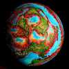
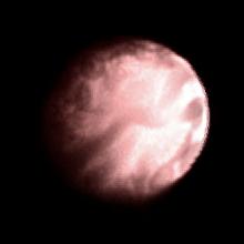
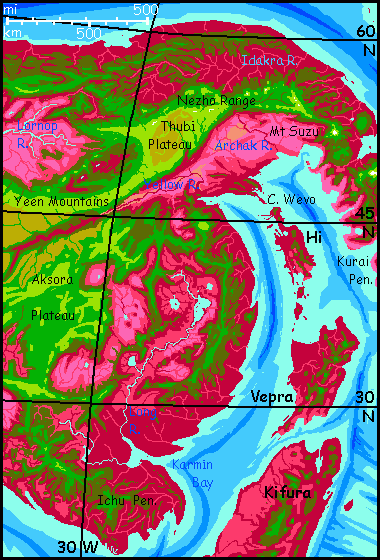
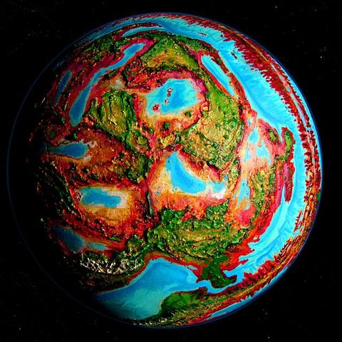
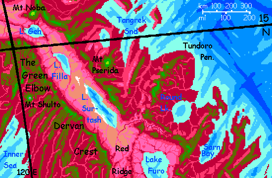
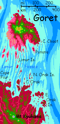
Capsica's homepage, map, giant ref map, geography,
gazetteer
. More worlds? Planetocopia!
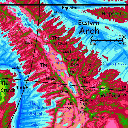
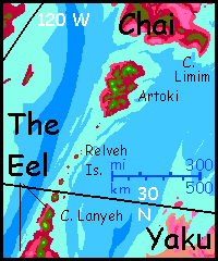
A Capsican Gazetteer
by Chris Wayan, 2012-23
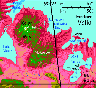
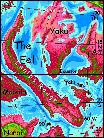
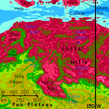
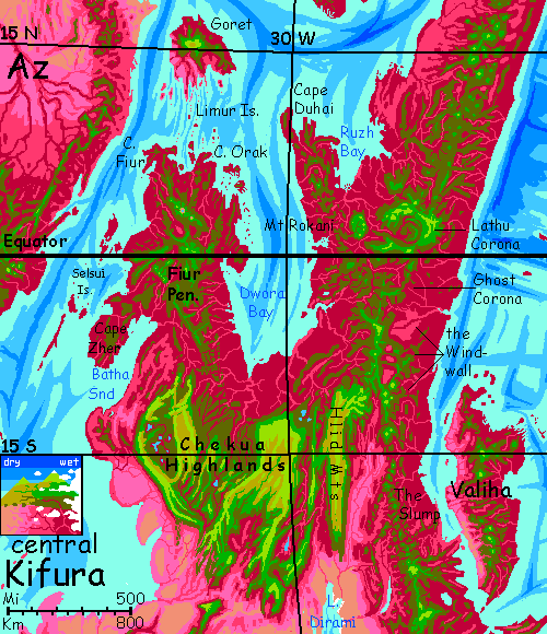
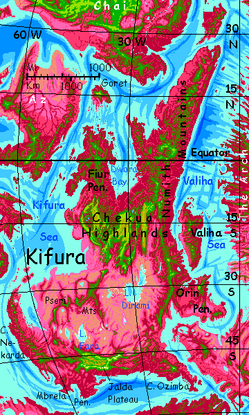
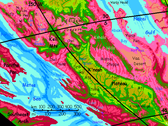
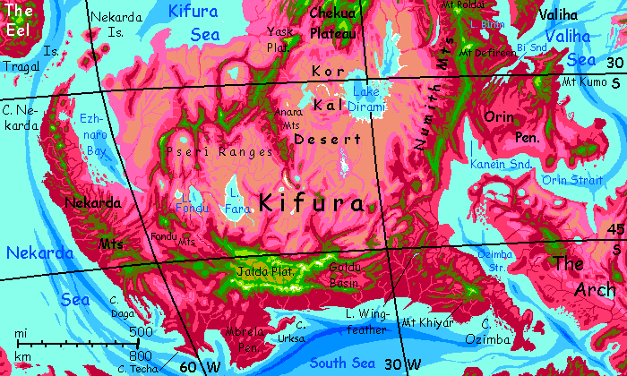
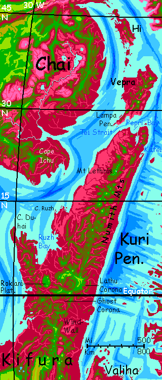
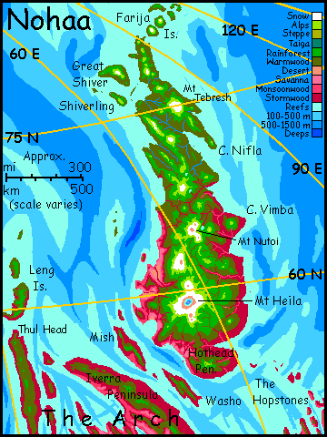
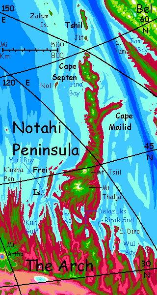
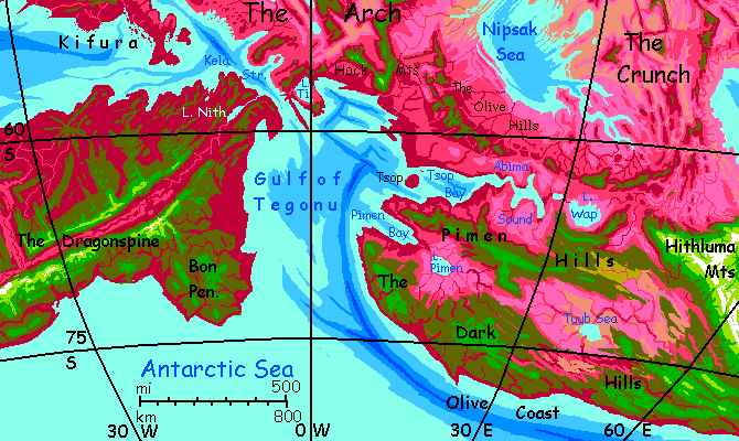
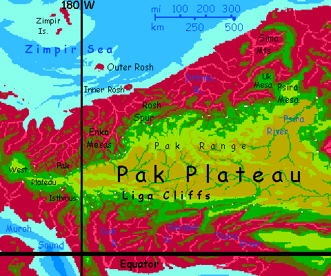
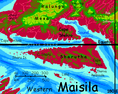
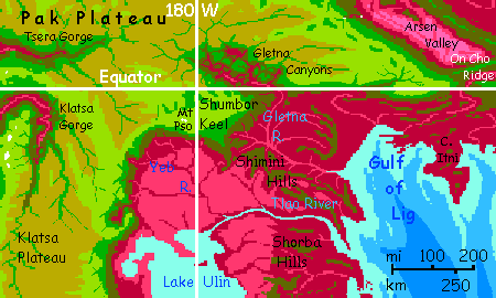
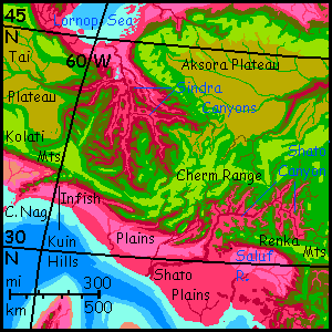
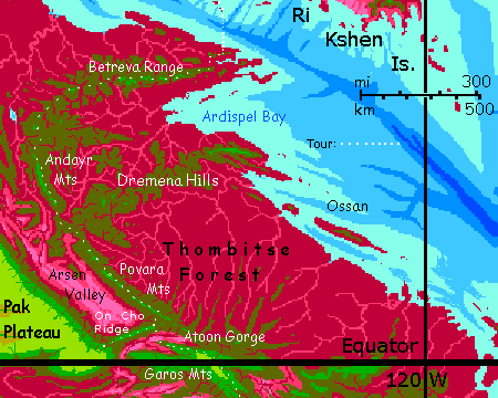
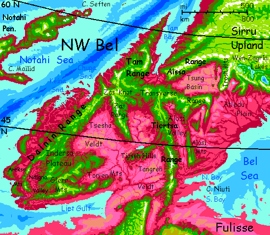
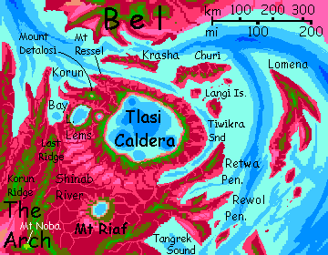
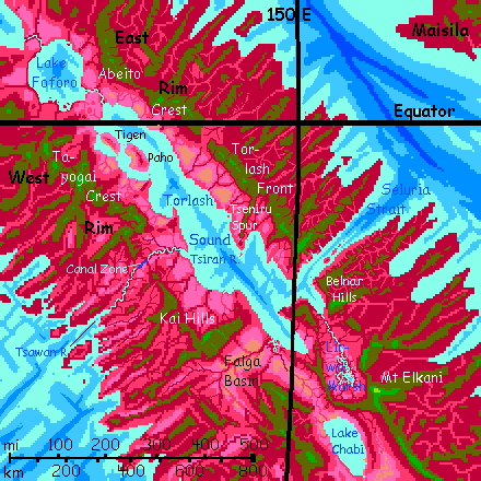
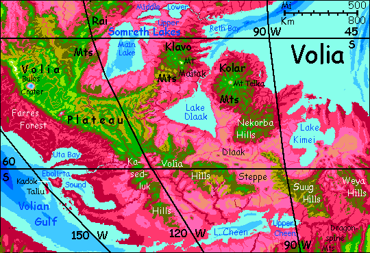
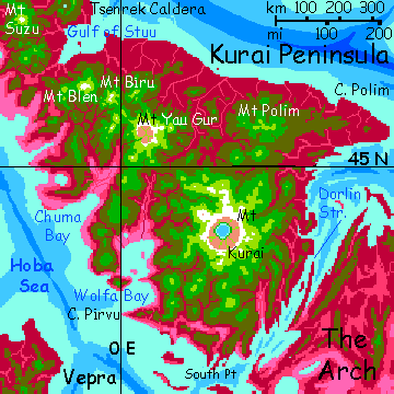
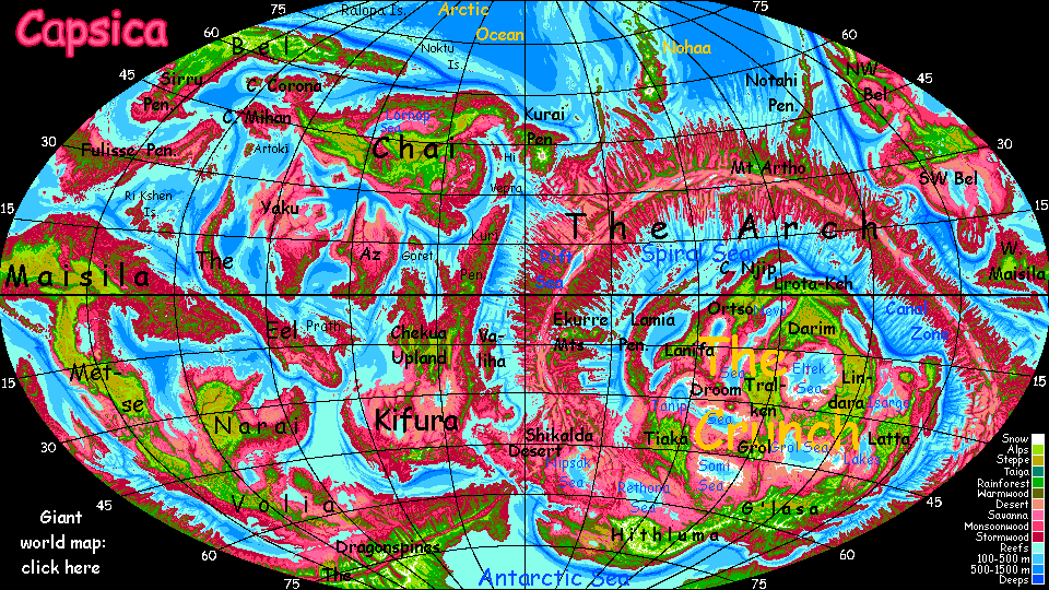
Why this elaborate reference page? For myself, mostly--I used it to build the planet! Gets hard to keep track of every mountain.
Roots of names: rather than creating fictional Capsican tongues to justify placenames, I've decided to trace their real origins; it reveals much about my creative process. Most do have roots in Earth languages, though I recognized some sources only long after coining them. Most refer to hot things, as seemed only right for Capsica. Though the definition of hot is broad indeed. Had to be. Planets are big! Even little planets are big. I needed lots of names.
Jump to A - B - C - D - E - F - G - H - I - J - K - L - M - N - O - P - R - S - T - U - V - W - Y - Z
- Cape Aa is a hot dry grassy point 50 km long; the eastern tip of Az. Fatally hot year-round for tourists. (Source: Hawai'ian a'a, lava cinders. Though the cape's not that bad for native Capsicans.)
- Abaki Bay, in southeast Metse, runs 640 km (400 mi) along the east coast, sheltered by long narror Cape Yanis. Abaki is 80-100 km wide (50-60 mi); the shores are arid and sparsely settled; Port Vaa at the head of the bay is the only town of consequence. The west coast does have villages at the mouths of creeks running off the K'nash Plateau. (Source: Arabic 'Aqaba', garbled; the long sound and dry shores resemble that gulf.)
- Abeito Crest is a mountain range in the eastern Arch just north of Torlash Sound. The Crest is the eastern rim of the rift valley creating the Arch; it runs about 480 km (nearly 300 mi). The Abeito front range averages 3 km (10,000') with peaks up to 4 km (over 13,000'), rising abruptly from the rift valley cupping the Sound. To the northeast, spurs run at right angles to the main ridge, as if Abeito were a huge comb. Abeito's highlands are quite Terran-tropical; hot and green in winter (as opposed to hotter still in summer); the slopes down in the rhodophore zone are another world--one quite fatal for Terrans. (Source: scrambled Ute or Paiute 'Toiyabe', dark or black: name of the national forests of Nevada's 'washboard' ranges above desert valleys. Abeito features a similar washboard, though lowlands are rainforest not desert. But equally hot and deadly.)
- Abima Sound, in the Antarctic, is a lobed, winding estuary downstream of Lake Wap and opening to Tsop Bay. Abima Sound is 400 km long, with multiple arms 50-80 km wide (250 by 30-50 mi). The water's brackish and shallow but navigable. Cold in winter--often 30°C (86°F) and occasionally 20-25 (68-77°F)--but most of the year, muggy, buggy and not worth visiting. (Source: Amoeba spoken backwards; from its lobed shape. Or maybe the parasites you'll catch if you visit the marshes.)
- Mt Aidano rises in the far eastern Crunch; the highest peak on Mako Plateau, it reaches 5.8 km (19,000')--not quite enough at this low latitude to see winter snow in a normal year, but close. Aidano's green head, usually cloud-wraped, is a navigational aid for hundreds of km around. (Source: English 'I dunno' because after a thousand placenames I just couldn't think of another. It's still better than Antarctica's "Executive Committee Range." Ah, wilderness!)
- The Aissa Range in northern Bel is a great spur of the Sirru Highlands; the Tien Shan to its Tibet. The Aissas run 640 km (400 mi) west, just north of the stark Tsung Basin (and rainshadowing it). Peaks are 7-8 km high, and at least 6 km (20,000') base to top. A major flyway between Northeast and Northwest Bel. (Source: the legendary Third State of water: solid, transparent to white, burning at a touch)
- The Akalpa Mountains rise along the southern edge of G'lasa Plateau in the southeast Crunch, topping out just over 7 km--a bit taller than the Andes. A major flyway some 2500 km long (1500 mi). Climate: subpolar (45-60° south) so taller peaks get substantial winter snow; a few southern peaks even have glaciers. (Source: Aymara 'allpaca' / Spanish 'alpaca' scrambled: a warm wool. You'll actually need such a sweater here in winter.)
- the Aksora Plateau is in east-central Chai. This grassy plateau averages 4-5 km high, but the rim rises to 8 km in the Cherm Mts in the south and Yeens in the north. To the west, beyond Sindra Canyon, Tai Plateau is part of the same highland. Like Tibet, it represents two tectonic plates colliding and essentially stacked. (Source: Amharic 'Axum' plus Egyptian 'Luxor'? The plateau resembles Ethiopia.)
- Alaku is the port city for the Millim River Basin and much of Tiaka Plateau in the western Crunch. Alaku is in the Millim Delta where it meets Witon Gulf. For Terrans, the Delta's fatally hot year-round; don't visit. (Source: Malay 'kuala', estuary, garbled.)
- Aldrak Spur is a scattering of volcanic cones in the western Arch, on the Rift floor, around 10-12° south. The field includes at least a dozen peaks and crater lakes. With Mt Jiferu to the east, the spur forms a flyway for heat-intolerant tourists crossing the equatorial Rift. (Source: English/Latin caldera garbled.)
- Algarfa Savanna is a rolling grassy plain northwest of the Rift in the western Arch; about 500,000 square km (200,000 sq mi). Algarfa's one of the few regions of the Arch where winter rains can blow inland, unblocked by mountains almost to the Rift. Still, total annual rainfall's low; Algarfa's sparsely settled. (Source: Latin flagra, fire, scrambled and Arabized; the low plain's fiery hot)
- Cape Aluva is in Western Maisila; a bulbous point jutting c.160 km (100 mi) from the south coast into Aluva Sound between the mainland and the huge island of Sharutha. Alufa's central hills are just high and cool enough in orbital winter for Terrans to survive, but it's a dead end far off any useful flyway. Most of the peninsula is low rainforest, fatally hot--Aluva's just a degree from the equator. (Source: Latin uvula, garbled; the pendulous, bulbous cape resembles a uvula.)
- Ammet Corona is a broad island-ring in the northeast Ri Kshen Islands, a tropical archipelago west of the Eel. It looks like a Terran atoll scaled up triplesize, but the origin is quite different; it's a corona, a concentric rise common on Venus. Nearly 400 km across (250 mi), Ammet's broken into arcuate ridges: some are narrow cliffwalled islands up to 50 km long but never more than 5 wide (30 by 3 mi); some mere reefs. (Source: Drowned Ammet, my least favorite book by Diana Wynne Jones. Ammet's mostly underwater.)
- Lake Amoka is a salt lake in western Metse; a comma-shape 30-35 km by 15 km (c.20 by 10 mi)--somewhat variable seasonally and year to year. The Lin River runs south some 250 km (150 mi) to dead-end in the lake. The basin is desert at low elevations and dry prairie higher up. Fatally hot except a few rare days in winter; but a few surrounding heights support green trees and are visitable year-round.(Source: English "a comma" reversed; it's comma-shaped.)
- Anaheim is Capsica's outermost moon, 150,000 km out, orbiting every 9 days. Anaheim is small, 500 km in diameter, but spherical, with an apparent diameter about 3/8 of Luna. The surface is reddish. (Source: a (not very) hot pepper)
- Andayr Ridge, in northeast Maisila, runs north from the central highlands most of the way to the coast; the best flyway to the Ri Kshen Islands. An unbroken wall 250 km long (150 mi); highest points reach 3.8 km (12,500'). Pronounced "And ire" or "Ann dire". (Source: English "andiron"? The range is straight as a poker, and equatorial Maisila is as hot as a hearth.)
- Anetna Sound is a many-fingered gulf in the southeastern Arch; about 500 km (300 mi) from mouth to head of the deepest branch by air, though nearly 700 (430 mi) as the ship sails. Anetna's convoluted shores are hot and dry, part of the Nigavni Desert; but washboard ridges often rise high enough to snag some rain, if not high enough for Terrans to travel safely. Fishing is good, and villages dot the coast wherever creeks descend from the rainier highlands. (Source: English 'antenna' reversed; the coastline looks like an old TV 'fishbone' antenna. I nearly named it Nobshif.)
- Angin Swell is a stretch of the central Pasang Range on Lamia Peninsula, off the NW Crunch. Angin isn't exactly a ridge or plateau, but between: overlapping lava flows have built up an irregular strip 3 km high with numerous cones rising to 4 or 4.5 (up to 15,000'). The high Swell is green cloud forest; a few peaks are opener, above the typical cloud levels; lowlands east and west are ruby rainforest. A popular flyway as it stands across the prevailing winds, creating steady updrafts. (Source: Malay 'angin', wind
- Api is an L-shaped desert cape on the west coast of Yaku, about 160 km long (100 mi). Low and rainless most of the year; the highly specialized plants harvest drops from coastal fogs to survive. (Source: Malay: fire)
- The Arc is the lower northern stretch of the Luf Tif Hills, a long broken range in the southern Crunch. The Arc's ridges are just 3.7 to 4 km high (12-13,000') but stretch some 500 km (300 mi) in a great curve. Few trees, only along streams and on higher peaks; the hills snag more rain than the lowlands, but still less than the plateaus they link. (Source: translation of descriptive local name, from the great curve.)
- THE ARCH is a long curved crustal-spreading zone of ridges and rifts like our mid-oceanic rifts laid bare. Outside the Arch is the Outer Hemisphere (if you ask the Innerians) or Greater Hemisphere (if you ask the Outerians) where the crust really can spread; inside the curve, platelets compress, tilt and stack into The Crunch, a continent-sized mass of highlands and desert basins: the Inner Hemisphere (if you ask the Innerians) or the Lesser Hemisphere (if you ask the Outerians). (Source: resembles an arch on most map projections)
- Arch Canal is a dream slowly turning real. At present it's just a small-boat channel linking the Tsawan and Tsiran Rivers into a 200-km (125-mi) canal crossing the eastern Arch about 5° south of the equator. The artificial portion crossing the Kai Gap between the two rivers is 40 km long (25 mi), ten meters wide, and two deep. When enlarged enough for cargo ships it will shorten shipping routes by up to 30,000 km (19,000 miles) (Source: common sense.)
- Archak Plain is a low, fertile riverplain in northeast Chai. The Archak River drains the himalayan Nezha Mts; its lower half winds across the rather Mediterranean plain. (Source: English: a somewhat worn down name for an edible thistle)
- Ardispel Bay is a triangular gulf on the northeast coast of eastern Maisila, 640 km long and about half that across the mouth (400 by 200 mi). Dense monsoon forest covers the coast, cloud forest the hills. Except a few peaks, it's all too hot for Terrans. These hills are too rainy for most Capsicans, but fishing ports dot the (somewhat) drier coasts. (Source: Greek clipped and reversed: "klepsidra", a water clock, an ancient device measuring time by dripping water. Drip. Drip. Drip. Which sums up the climate.)
- The Arekse Range is a complex of volcanic arcs near the western tip of the continent of Bel. Nearly 1000 km long (c.600 mi), the Arekses are several overlapping ranges, lower near the coast, topping out inland at 4.5 km high (15,000'). The coastal ranges and lowlands get plenty of rain and are wooded--red foothills, olive heights. The highest arc has green forests and meadows on some peaks, with temperatures bearable to Terrans most of the year. (Source: English 'arcs'; range resembles parallel island arcs.)
- Arka Mountains run south of Lanifa Plateau in the northwest Crunch, forming its southern edge, but stretching well beyond to the east. 1100 km long (720 mi), the Arkas' peaks are 5-7 km high (16-23,000'). Slopes and summits catch enough rain for trees and shade, but the Lulu Valley to the south is dry savanna. A solid, safe flyway, even for Terrans. (Source: Russian 'arka', arch; the range curves gently like a long arched bridge.)
- Arkuelda Desert is an inland basin near the tip of the Fulisse Peninsula. Triangular, 5-800 km on a side. The two forks of the shallow Arkuelda River meet and run through the center; most of its water evaporates before it reaches the sea. Coastal mountains 2 km high surround the basin, blocking storms in every direction. (Source: an electrical tool fusing metal objects with extreme heat)
- Arsen Valley is a savanna basin in northeast Maisila between Pak Plateau and the Povara Mountains, which cut off most rain.The basin is 600 km long and 200 wide (375 by 125 mi). Equatorial, sunny, and low-altitude, it's one of the hottest places on Capsica, regularly reaching 75°C (167°F). (Source: a fiery crime)
- Mt Artho is a shield volcano 10 km high (nearly 33,000') and several hundred km across, in the northeastern Arch. It stands alone, though it may be geologically linked to the similar shield volcanoes of the Notahi Peninsula farther northeast. Due north of the mountain is Port Artho, exporting products from its many climate zones (and housing and outfitting hordes of pilgrims who hold the mountain sacred). (Source: uncertain; Latin 'arthro', joint? The Arch bends south at this point.)
- Artoki is an island the size of Taiwan south of Chai and west of Yaku. Hot rainforest in the east, green in the central mountains, meadows and groves on the west. Probably a corona. (Source: uncertain. Dark Toki, an online furry artist? Toki's pelt is plum-colored like the Artokian forest)
- Cape Asap is a desert peninsula 200 km long and wide, off northwest Yaku. Dry grassland and desert; low hills. These continue offshore as the Asap Islands (four major isles from 10-50 km across), to the north. (Source: Malay: smoke)
- Mount Asap is the only active volcano on the Lamia Peninsula, off the NW Crunch. Asap is just one of several cones on a broad base 3 km high; its summit (currently) is 4.9 km high (16,100'). The platform is green cloud forest; Asap's summit are opener, above the typical cloud levels; lowlands east and west are ruby rainforest. A popular flyway as it stands across the prevailing winds, creating steady updrafts; but avoid the cone itself. Magma here is thick, often plugging vents; infrequent but deadly explosions. (Source: Malay 'asap', smoke)
- Lake Asha is just south of the Ekurre Peninsula in the western Arch, at 10° south. Lake Asha is 550 km long but only 50-125 wide (330 by 30-75 mi). The lake drains east into Aucha Sound, an extension of the same trough--crustal sagging from the great weight of the shield volcanoes of the Ekurre Range. (Source: ashes? The lake-trough is the by-product of the eruptions to the north.)
- The Atoon Gorge is a steepwalled desert valley in East Maisila, cut off from rain by Pak Plateau, the Garos Mountains and On Cho Ridge. The gorge is 3-4 km deep (10-13,000'), 300 km long and 125 wide (180 by 75 mi). Equatorial, sunny, and low-altitude, it's one of the hotter places on Capsica, regularly reaching 70°C (158°F). (Source: Arabic: attuun, furnace)
- Aucha Sound is just south of Ekurre Peninsula on the Arch just south of the equator. Ekurre's massive shield volcanoes are so heavy the crust around the volcano-chain has slumped, creating Aucha Sound to the south and similar Auwi Sound to the north. Aucha is about 800 km long and 50-160 wide (500 by 30-100 mi). Lake Asha, to the west, is an extension of Aucha's trough. (Source: English: what you say when slightly burned)
- Auwi Sound is just north of Ekurre Peninsula on the Arch just south of the equator. Ekurre's massive shield volcanoes are so heavy the crust around the volcano-chain has slumped, creating Auwi Sound to the north and larger Aucha Sound to the south. Auwi is about 400 km long and 50-80 wide (250 by 30-50 mi). Lake Asha, to the west, is an extension of Aucha's trough. (Source: English: a child's term for a small burn)
- AZ is one of the smallest and least fertile continents. The Welda Desert covers north Az, broken only by the Nile-like Wasei River. Central Az is Sahelian, grading into equatorial rainforest in the south. The Timun Mts are the only part cool enough for Terrans. (English: 'Oz', slang for a certain hot continent, or short for 'azbest', a heatproofing mineral)
Jump to A - B - C - D - E - F - G - H - I - J - K - L - M - N - O - P - R - S - T - U - V - W - Y - Z
- the Ba Mountains are a northern stretch of the spine of The Eel. A line of Andean volcanoes 6-8 km tall (20-26,000'). The east slopes are rainforest; the rainshadowed west is the Emba Desert. (Source: reversed ab, short for abdominal, for their location in the eel)
- Bakar Caldera is a volcano in northern Lamia Peninsula, NW Crunch. Bakar was a stratovolcano 5-6 km high (16-20,000'), but within the last thousand years it collapsed catastrophically, leaving a C-shaped ridge 4 km high. The caldera's partly filled with lesser, recent cones. Many thermal pools. (Source: fire in Malay)
- Barrada Plateau is the largest upland of southwest Bel; big as Borneo, some 1600 km east-west and over 600 north-south (1000 by 400 mi). Most of the Barrada is 3-4 km high (10-13,000'), though its south and east rim rise to 5.5 km (18,000'), and Therron Spur, a thumb jutting north, reaches 4.8 (15,800'). Such peaks have occasional snow in winter; the plateau never does. It's quite Terran; a patchwork of green woods and yellow savanna, with almost no rhodophores. The few Capsicans here are antisocial types willing to shiver most of the year to escape the crowds of the rich lowlands around Liet Gulf and the Bel Sea. (Source: Arabic: to cool)
- Mt Barid is the highest peak on the Fulisse Peninsula. Located in the west-central part of Fulisse's mountainous spine, volcanic Mt Barid is 4.8 km high (15,900'); only a handful of the Peninsula's peaks top 3 km (10,000'). In summer it's the only survivable spot for Terrans; even in winter, the only comfortable one. Even the summit rarely if ever sees snow. (Source: Arabic: cool, cold.)
- Batu Gorge cuts into the northeast corner of Tiaka Plateau in the western Crunch. Dramatic falls up to 300 meters (1,000'); cliff walls to 2200 m (7200'). Trees only in the highlands, on streambanks and in spray zones. Two main forks, East and West, each about 250 km long (150 mi). (Source: Malay batu, 'stone'; the gorge has more bare rock than most such.)
- the Batu Hills rise in northern Lamia Peninsula, in the northwest Crunch. Steep and corrugated, with ridgetops up to 3.7 km (12,000'), well into the green zone, though mostly deep red rainforest. Many cliffs and waterfalls, but often too misty for long views. (Source: Malay batu, 'stone'; these hills are a rare place in Lamia steep enough to expose a few rocks.)
- BEL is a northern continent, west of Chai. Bel is the largest Outerian continent, as big as South America. Because it's large, spidery and diverse, there will be separate tours for cool green north, central and eastern Bel, the warmer, rugged northwest, the hot dry southwest, and the hot but not all dry Fulisse Peninsula in the southeast. (Source: Bell peppers: on average Bel's the coolest continent on Capsica.)
- BELL is the middle and largest of Capsica's three moons, some 800 km diameter (500 mi). 100,000 km out, it orbits in 4.5 Capsican days. Bell's apparent width is 7/8 that of Luna; its light is actually brighter as its albedo is higher (Luna is quite dark as worlds go). (Source: Bell peppers.)
- Lake Bellep is a narrow riftlake in the southwest Arch. Bellip is just 15 km wide but 95 long (10 by 60 mi), it's a hot, soapy mess of a lake, for hot vents down its centerline spew minerals making it undrinkable. Bacteria flourish, but not much else; it's a sickly yellow and reeks of sulfur. Mt Drith rises just to the east. (Source: English pebble, garbled; the lakeshores are quite bare.)
- The Belnar Hills are a range in the eastern Arch just south of Seluria Strait; the jumping-off point for crossers. High point 3.5 km (11,500'). In orbital winter the summits are bearable for Terrans; flanks and lowlands are fatal year-round. (Source: 'Bernal' hill, scrambled: Spanish dialect for 'vernal', spring-green; the name of my local hill.)
- Bes River is in the northwest Arch; a many-forked, shallow stream winding across the Bessema Desert, collecting runoff from high fracture-zone ridges over an area rivaling Spain. The Bes is the only stream here to reach the ocean, at the head of Maggama Sound, another fracture zone. (Source: worn-down from the desert's name; a furnace used to make steel)
- The Besh Peninsula is the southern tip of Az, the small continent south of Chai. A blunt cape 200 km wide and long. The coastal lowlands are extremely hot and humid; the central Timun Mts include peaks as high as 4500 m (14,800'), with cooler, almost Terran cloud forests. (Source: English slang for a hot party, or hot-tempered beating--fun folks, those English)
- Bessema Desert is in the northwest Arch; a rugged patch bigger than Texas and quite a bit hotter. Bessema is seamed and broken by wooded and brushy ridges, fracture zones from the rift creating the Arch. Winds here are weak; storms don't often penetrate past the coastal mountains. It's not as sterile or salt-poisoned as the Rift; in the south, the Bes River, fed by creeks from the high ridges around the basin, actually reaches the sea--well, Maggama Gulf, a fracture cutting inland almost to the Rift itself. Near Maggama Sound, Lake Dlima (a W-shape 200 km long; 125 mi) is brackish but drinkable; its basin is dry savanna, not true desert. (Source: a furnace used to make steel)
- Betreva Mountains are in northeast Maisila; an arc of volcanoes 880 km long (550 mi); the eastern coastal peaks are less than 3 km high; inland, several reach 4.5 km (14,800'); cloud-wrapped, stratovolcanic cones manteled in green woods and fern-meadows high above deep red Thombitse Rainforest. The range is a flyway to the Ri Kshen Islands; the most popular for natives, the only one cool enough for Terrans. (Source: English 'vertebra' scrambled: the arc of peaks resembles a spine)
- the Beye Islands lie off Lamia Peninsula in the NW Crunch. Beye's an equatorial archipelago 960 km long and 260 wide (600 by 160 mi) paralleling Lamia, with the largest islands near it. Beye proper, the biggest, is 250 km long and half as side (150 by 75 mi). All the land's smothered in red rainforest, except the highest peaks on the four largest islands, capped in (surprise!) green rainforest. Too hot and humid (near 100%) for Terrans even in orbital winter, but viewable I suppose from those four cooler summits--if the clouds ever part. (Source: uncertain, though most nearby placenames were inspired by Malay words.)
- Big Gap is in the southeast Arch near Mt Haisa. Here the East Rim of the Rift breaks up into mesas for some 80 km, then vanishes entirely for 80 more (50 mi each). The Big Gap isn't that big by world standards, but to the south for several thousand km the Rims are essentially unbroken: the Dragonspines. The gap lets in more rain than usual for this stretch of the Rift; the low hills are savanna not desert, and seasonal streams feed brackish Lake Thorbe. (Source: translation of local term.)
- Big Spur thrusts 240 km (140 mi) out from the northeast corner of Tiaka Plateau in the western Crunch. Peaks up to 8 km (26,000'), chartreuse fern-fells veined with dark pseudopines on the shoulders; below, cascades down cliffs into the red zone; savanna all round. (Source: translation of local name; the largest of many spurs on Tiaka Plateau's north rim.)
- Bil Island is the east end of the Tharaji Chain southwest of Western Maisila--an equivalent of a Terran island arc. A diamond shape, 50 by 80 km (30 by 50 mi), Bil is rugged, with a line of volcanic cones down the middle topping out at 2750 m (9000'). Monsoon forest, slightly rainshadowed by Klatsa Plateau to the east. Not recommended for Terrans, even in orbital winter. Bil Spur, on the mainland to the east, is a continuation of the same rise; several ridges rise to over 4 km high on the rim of Klatsa Plateau. (Source: Bali in Indonesia? The island arc resembles the Sunda Is.)
- Bing Pass in the G'lasa Highlands, southeast Crunch, is the best way across the central Akalpa Range; 4.5 km high (14,800'). Feared by Capsicans as the 7-km peaks flanking it (23,000'!) are snowy most of the year. (Source: uncertain, but not the singer, the cherry, or the Chinese word for sick.)
- Lake Binin is in southeast Kifura; a peanut-shaped lake just east of the Numith Range, Kifura's Andes. Binin is shallow, warm, 95 km long and half as wide (60 by 30 mi). (Source: 'bean', for the shape.)
- Mt Biru is a shield volcano on the Kurai Peninsula in east Chai. Though old and eroded, Biru's central peak is still 9 km high (just under 30,000'), high enough for a sizeable snowcap and even a few glaciers. It has a near-twin 160 km to the west, Mt Blen. (Source: Japanese: a drink served cool, except in barbarous nations like England)
- Bito Canyon is on the coastal rim of the northern Lanifa Plateau, in the northwest Crunch. About the size of the Grand Canyon, but as deep as 2.5 km deep (8000'). Slopes are equatorial rainforest; waterfalls abound. (Source: English 'hobbit', a half-sized people; the gorge is hobbit-sized next to Rugo Gorge to the south. Also, the climate & scenery resemble the isle of Flores--home of a different species of hobbit.)
- Mt Blen is a shield volcano on the Kurai Peninsula in east Chai. Though old and eroded, Blen's central peak is still 9 km high (just under 30,000'), high enough for a sizeable snowcap and even a few glaciers. It has a near-twin 160 km to the east, Mt Biru. (Source: worn-down Russian: blednye, white)
- Bolte Gulf is a wide tilde-shaped sound in the northern Arch. At 500 km long and up to 400 wide (300 by 250 mi), Bolte is several times bigger than the many narrow sounds created by the Arch's fracture zones around its central rift. Local fliers routinely cross the mouth of the gulf, but Bolte is problematic for Terran tourists in rented wings. Recommended: go round via the Urra Isthmus, Mt Isai, and the Long Ridge. The Bolte shores are fertile--mostly red forest, now orchards. The climate's mild for this high latitude: Iverra Peninsula blocks Arctic storms. Sadly this means the port cities are too hot for Terrans even in winter; humid, too. Stick to the mountains. (Source: the gulf's shaped like a cartoon lightningbolt.)
- Boluu Sink, in the western Crunch, is an inland basin scooped out of Tiaka Plateau. Boluu is a roughly round patch about 250 km across (150) mi, about 2.4 km deep (7900'). The plateau's semiarid so there's only a modest, brackish central lake. Subsidence? Erosion? Unclear. (Source: English 'bowl' garbled a bit. Unlike the plateau's other gorges and sinks, Boluu's not cliffwalled.)
- Bomok Bay lies off Lamia Peninsula in the NW Crunch. Bomok's a complex sound about 500 km long and 400 wide (300 by 250 mi); the west shore especially is serrated with capes and inlets. The north shore, rugged Cape Bomok, is 500 km long and 160 wide (300 by 100 mi). Many maroon islands where trees overhang the water. All the land's smothered in rainforest--the bay's equatorial. Too hot and humid (near 100%) for Terrans even in orbital winter, but viewable from the ridges to the west. (Source: looks like Malay (to match many placenames in the region) but it's fake; really English 'comb' reversed. The shore's like the teeth of a comb.)
- Bon Peninsula is a blunt thumb sticking into the Antarctic Sea, about 400 km wide and long (250 mi). Bon's low hills are densely forested--mostly olive (mixed red & green); red dominates only right down at sea level, and dark green pseudofirs prevail just 2 km up. The hills are comfortable for Terrans in winter and survivable even in summer. Bon is a jumping-off place to cross Tegonu Gulf--a grueling daylong flight for Terrans, but feasible. (Source: Japanese? Bonsai (the trees are dwarfed; it's the Antarctic)
- Boosh River is in southwest Metse; a many-branched stream 250 km long (150 mi). The upper Boosh is on Metse Plateau; high steppe; at the plateau rim, several branches drop in impressive falls up to 1.5 km high (5000'). The lower river crosses the Skoboosh Desert to end in Kifo Bay. The upper reaches are safe for Terrans; the lower valley is fatal even in winter. (Source: English 'shoebox', reversed, for the desert's shape, and split to name the two streams crossing its southern flats.)
- Bora Island, in the Inner Sea just off the central Arch, is a tilde shape 130 km long and 110 wide (c. 80 by 70 mi). Bora is rugged--part of a fracture-zone ridge, though none of the peaks top 1600 m (a mile). Summer monsoon rains support forests; much of the island is orchards. One of the more fertile and populated parts of the central Arch. (Source: Polynesian? Topography's a bit like Bora Bora, though way bigger and bright red...)
- Borath Bay indents the north coast of eastern Maisila. The bay winds 640 km (400 mi) south, and is up to 280 km wide (175 mi), though a line of large islands down the middle break the bay into a skein of channels; you're never more than 75 km (45 mi) from land; mostly much less. The basin is equatorial rainforest muggy even for Capsicans; hilly, but with no peaks high and cool enough for Terrans, even in winter. (Source: probably broth seasoned with divine wrath. You're in hot water now!)
- Cape Boreh is an arcuate spur of the mountainous spine of Zil Peninsula (NE Bel). The Boreh Mountains resemble our Brooks Range or the Koryaks of eastern Siberia; the cape is more a bulge than a fully separate finger. It's big--the range is over 800 km long (500 mi). The arctic side is so cold by Capsican standards that it's green almost down to sea level; Arctic blizzards bring actual if brief freezes. The mountains get extensive snow, though they're too low for glaciers. The southern, inland, sheltered side has red lowland forests and green heights. Nearly all the population lives here, in Rimshak Valley. (Source: Greek: boreas, the north wind)
- Box Cove in the G'lasa Highlands, southeast Crunch, is a cliffwalled bay in the plateau's north rim about 80 km (50 mi) across. The alluvial floor is rock, scrub and pink savanna; the rim, 3.8 km high (12,500'), green; trees only along streambanks. (Source: translation of local terms for 'box canyon' and 'bight in a highland or mesa', plus the fact it IS roughly rectangular; literally boxy.)
- The Breaks are a Texas-size region of the northeastern Arch where the Rift has no definite south rim. Tourists can fly between ridges to traverse the region by roundabout routes. The Breaks let more rain into their stretch of Rift floor, so much of it is savanna not desert. (Source: translation of local name)
- Bren Veldt is a savanna in the eastern Crunch on the east shores of Lakes Ombok and Ndeba. A wedge 1000 km long and half as wide, it's as big (though not as dry) as Nevada; groves and meadows in the north nearer the sea, savanna in the middle, semidesert in the south. Mostly flat, but endless north-south compression ridges, the Ombok Waves, corrugate the far north. (Source: German 'brennen', to burn; scorching hot year-round, and fireprone in the south)
- Brrn Island, in the Inner Sea, lies just off Cape Telisto in the central Arch. Brrn (long trilled rrrrrr) is 130 km long but just 25 km at the widest (80 by 15 mi). A fracture-zone ridge, Brrn is low but rugged, and mostly covered in woods and orchards; it's far enough south to get more reliable monsoon rains than most of the central Arch. Fertile, densely settled, prosperous, but fatally hot for Terrans, even in winter. (Source: a cooking technique for meats, heretics, etc; not recommended.)
- Buhar is an island off the northeast Arch. Low, irregular, hilly, covered in red stormforest, Buhar is nearly 300 km long and half as wide (180 by 90 mi). Steamy even for Capsicans; not just uninhabitable for Terrans but unvisitable, even in winter. (Source: Arabic: bukhaar, steam)
- Bulos Crater is the largest impact feature on Capsica; a crater 185 km wide (115 mi). Only 9 million years old, and thus far more prominent than Chicxulub on Earth. The outer wall rises over a km; central Lake Bulos is a deep blue eye 110 km across (70 mi). Set high on Volia Plateau amid green forests and meadows, the crater rim can be visited year-round by Terrans; shaded south slopes even get some winter snow. But in summer, the lake shores, 2-3 km below the rim, get dangerously hot--beware! (Source: English (from Greek) 'bolide', a meteor? or Mayan -xulub reversed?)
Jump to A - B - C - D - E - F - G - H - I - J - K - L - M - N - O - P - R - S - T - U - V - W - Y - Z
- THE CANAL always refers to one canal: a small-boat channel linking the Tsawan and Tsiran Rivers into a 200-km (125-mi) canal crossing the eastern Arch about 5° south of the equator. The artificial portion crossing the Kai Gap between the two rivers is just 40 km long (25 mi), ten meters wide, and two deep. When enlarged enough for cargo ships it will shorten shipping routes by up to 30,000 km (19,000 miles) (Source: common sense.)
- CAPSICA is a small planet whose average temperature's exactly midway between freezing and boiling: 50°C or 122°F. Juuust right! Only Terran tourists--those apes fresh out of an Ice Age--call that hot. (Source: Latin: genus of hot peppers)
- The Center Hills create the Center Peninsula in the eastern Arch, on the south shore of Torlash Sound. A roughly rectangular highland 120 km long and 95 wide (75 by 60 mi). Highest peaks, 3.2 km (10,500'). Notable mostly as part of the best flyway across the Rift for thousands of km; from the Belnar Hills on the East Rim to the Center Hills, south along Lirwa Ridge to the Narrows, and across to the West Rim. (Source: translation of local name.)
- Lake Chabi lies in the eastern Arch, south of Torlash Sound. Most rift lakes like Chabi are salt, lacking an outlet, but Lake Chabi drains into the Sound and is fresh. Chabi is oval, 225 km long and over 100 wide (140 by 65 mi). The outer walls flanking the rift snag much of the equatorial rain, so the shores of Chabi are mostly savanna; still, this treeless basin is fertile for the Rift. Lake Chabi is far too hot for Terrans to visit; the water's hot enough to sting. Torlash can only be viewed from the rift-valley walls, which commonly rise to 3 km (10,000') and occasionally to 4.5 (nearly 15,000'). (Source: chubby, from the lake's rounded shape?)
- CHAI is a mountainous continent as big as South America, vaguely shaped like East Asia. Its central mountains and plateaus are tolerable to Terrans in winter. (Source: a hot spicy drink)
- The Chao Islands are 200 km off the south coast of Az. Chao proper is by far the largest, a Y shape about 120 km (75 mi) long and half as wide. The archipelago is equatorial rainforest. (Source: Chinese: stirfry, hence English: chow)
- The Charash Hills, southeast of G'lasa Plateau, rise 1-2.5 km (3-8000') above the Antarctic Sea. Their olive (mixed red & green) forests are comfortable for Terrans in winter--even cool--and hot but livable in summer. (Source: an English cooking method (not recommended) plus resulting burnt debris.)
- The Charr Range is the highest in northern Yaku, spanning the Yaku Desert north to south, from Nomak Bay in the north to Salsu Gulf in the south. The range is more a straggle of whalebacks in the northern desert; in the south it's one long ridge rising as high as 3 km (10,000'), high enough for Terrans to survive in winter, though getting there is a problem. Shallow, marshy Lake Charr lies along this ridge's eastern foot. It grows to 400 km (250 mi) long in the rainy season, shrinking to 300 (190 mi) in the dry.) (Source: a cooking method (not recommended))
- Mt Chatni is the highest peak on the Lampa Peninsula, on Vepra, north of Kifura. Chatni, a volcanic cone, is 3.6 km high (11,800'). (Source: a hot side dish; the peak is hot year-round.)
- Lake Cheen and the Cheen Marshes, at the foot of the Dragonspine Mountaints, are the southern border of Volia. Lake Cheen proper is a freshwater inland sea over nearly as big as our Caspian, some 900 km long and nearly 400 wide at the east end (560 by 250 mi). Upper Cheen, 320 km long and up to 250 wide, though mostly narrow (200 by up to 150 mi) feeds the main lake; it drains through the Cheen Marshes to the world ocean, keeping The shores are mostly wooded, but trees thin to marsh and prairie in the east. High-latitude, hence cool for a sea-level basin on Capsica; even visitable in winter cold snaps (down to 25-35°C (77-95°F). But if it heats up to 40+ again (104°F) there are no nearby highlands to flee to. And don't forget the bugs! Best avoided. (Source: uncertain; possibly Tolkien? The high-latitude Midgewater Marsh east of the Shire is full of peeping "neekerbreekers". And let's not forget Dr. Seuss: the Sneeches.)
- The Chekua Highlands are a tangle of plateaus, ranges and canyons in central Kifura as wide and high as Tibet. Nearly equatorial, Chekua gets significant rain; more Ethiopian than Tibetan. Grasslands with trees along watercourses. Two lower, drier basins (still 2-3 km up) have lake districts, one brackish, one freshwater. (Source: Quechua, scrambled; though Chekua's greener than the altiplano.)
- Chel River in southern Metse drains northern K'nash Plateau. The Chel's 550 km long (330 mi); the upper half carved branched gorges up to 2.5 km deep (8200'); the lower Chel meanders west through Chel Veldt to the sea. Just east of the gorge is Chel Spur, a hundred-km tongue of rugged highland thrusting north into Edipsa Desert (and by blocking rain, helping to create it). (Source: uncertain.)
- the Cherm Mts are in central Chai; the south edge of the Aksora Plateau. The Cherms are a complex tangle; peaks reach 7-8 km (23-26,000') and much of that height is exposed, since the Cherms divide Sindra Canyon to the northwest and Shato Canyon to the southeast. The Cherms are snowcapped much of the year, though they have no glaciers. (Source: uncertain. Chairman Mao? The Cherms resemble the ranges of southwestern China. Or 'chern-', Russian for black? The Cherm peaks are dark rock. Or 'merch' scrambled, for the merch I ought to offer--oh, the global T-shirts!--but just can't bother.)
- Mt Chernai is a volcanic cone in the eastern Arch, on the West Rim; part of its flyway. A green island 4.8 km high (15,800') with its feet in red rainforest. Many daughter cones and winding ridges--old lava flows. Chernai's shoulders are quite Terran-tropical; lowlands fatal year-round. (Source: Greek 'Arachne' scrambled: the volcano's wandering flows look spidery on the map. Possible influence: Russian 'cherny', black; the basaltic lava is quite dark)
- Chikatu is an island off west Chai some 750 km long and half as wide (450 by 225 mi). Mostly cool red forest (still stiflingly hot and damp to Terrans), but two volcanoes near the east end rise to 4-5 km--green and visitable. (Source: Alaskan? Cheechako (greenhorn), or the Chugach Range?)
- Mt Chili is a volcano in central Vepra 4100 m high (13,400'). Its summit, snowless year-round, is one of the few spots on the flyway between Chai and Kifura that's tolerable to humans. (Source: a hot pepper)
- Mt Chipotle is a volcano in southern Vepra 5 km high (16,500'). Its summit, though snowless year-round, is one of the few spots on the flyway between Chai and Kifura that's comfortable to humans. (Source: smoked pepper)
- Mt Chirai in the southwest Arch is part of the East Rim--a rugged, tilted block thrusting 7.6 km (25,000'), several km above the surrounding peaks. High enough for snow in winter; the only snow for nearly 2000 km in any direction. (Source: uncertain.)
- Lake Chogmi is an L-shaped lake in west-central Kifura, between Malin Plateau and the Dzil Range. Chogmi is 80 km long and nowhere more than 25 km wide (50 by 15 mi); having no outlet, it's brackish. The Chogmi Basin is 2.4 km high (7500'), supporting mixed red and green vegetation--more brush and meadows than open woods, as it's semiarid--rainshadowed all around. At just 15° south, it's just survivable but miserably hot for human tourists year-round. (Source: uncertain. Shortened from Choggenmugger, a dragon in one of the Oz books? It's certainly dragonfire-hot.)
- Chon Sound is a bay gouged into the south coast of western Chai. Chon is about 250 km long and 185 wide (150 by 110 mi); the shores are red forest, and too hot to visit, though it's almost bearable in winter. But the maritime humidity makes even a cool winter drizzle of 40°C (104°F) hazardous for humans. (Source: probably 'notch' backward. In a region full of radial corona structures, the sound stands out as a straight slash, as if a lumberjack quit halfway through a cut.)
- The Chokal Hills rise in northern Maisila; a maze of olive-wooded ridges, knobs and mesas above ruby rainforest. Peaks near the Pak Plateau in the south rise to 4 km; 2-3 is more common in the north near the sea. Humid--both rain and mist. Many waterfalls. The Chokals are a year-round flyway for locals heading to and from Fulisse, but Terrans can pass safely only in orbital winter. (Source: Mexican Spanish, from Nahuatl xocolatl, 'bitter water'; a hot drink. The hills resemble the Central American hills where chocolate originated)
- The Chona Lakes are half a dozen fingerlakes on the Humma Peninsula, the southern tip of Bel. Up to 210 km long though averaging just 30 wide (130 by 20 mi), the lakes are deep enough for large ships, making agricultural exports easy for even inland farms in this lush region. Lush but untourable: the surrounding hills are too low to provide any relief for Terrans from fatal heat even in winter. (Source: nacho, a hot-spiced snack)
- Choot Basin is a swamp as big as Louisiana in western Maisila. Knolls of dense rainforest rise from winding reed-channels. Choot is barely 5° north of the equator, and far too hot and humid for Terrans to visit, though you can look down on it from the cliffs of Ralunga Mesa just to the south and east. (Source uncertain)
- Mt Choran is a peak in the eastern Arch, on the west rim of the Rift. Really a mountain range 160 km long (100 mi); the summit, is 5.7 km high (18,900'). Being equatorial, the lowlands are fatal year-round; the highlands are green and quite Terran-tropical. Choran is the south end of the so-called Red Ridge, a flyway bridging the Rift. (Source: ''anchor" garbled; it anchors the Red Ridge.)
- Choro River drains most of the Mihan Peninsula in southwest Chai, running about 650 km (400 mi) east to Limim Bay. The Choro Valley is meadow and grove country like a hotter Mediterranean. (Source: uncertain; Choronzon, one of the demons in the fiery Christian hell? Or chorizo, a spiced sausage?)
- Chuma Bay is a triangular bight about 250 km on a side, on the west coast of the Kurai Peninsula in Chai. Chuma's shores are dry savanna, though the hills have rather Mediterranean groves and woods; the region's rainshadowed by Mt Yau Gur. (Source: uncertain. Mocha, from its dry brownish shores?)
- Chunza is an island off Lamia Peninsula's north shore in the NW Crunch. 240 km long but just 50 wide (140 by 30 mi), Chunza has deep red equatorial rainforest along its coasts and cooler but constantly wet cloudforest along its rugged spine, which is just survivable for Terrans in orbital winter, but not recommended. The island shelters Chunza Sound, 320 km long (200 mi). (Source: uncertain. 'Hunza', that long narrow Himalayan valley known for longevity, plus 'chorizo', sausage, from the shape and color?)
- Chupa Sound is a triangular bay about 200 km on a side (125 mi) on the northwest coast of Bel, reaching to the foothills of the Dalnin Mts. Cool-temperate for Capsica; year-round rains nourish dense dark-red forests, some of the richest on this generally arid subcontinent. (Source: Spanish, chalupa?)
- Churi Island is part of the Tlasi Caldera complex in the northeast Arch. Churi is 160 km long and 65 wide (100 by 40 mi). The lowlands are ruby rainforest, unvisitably hot year-round for Terrans; the (narrow) heights, olive woods marginally tolerable in cooler seasons. Churi may be part of an ancient, eroded, gigantic caldera wall; Krasha, the Langi Islands and Retwa Peninsula may be other remnants. (Source: uncertain. The churi's out...)
- the Coast Range (1) is in eastern Chai; its green ridges divides the red-forested coastal strip from the pink savanna of the Long River valley. Mostly 2-3 km high, and cool enough for Terrans only in winter; but Mt Hhuyu at the north end reaches 4500 m (14,750'). (Source: the sloppiness of sentients; they're miles inland but to a Capsican riding the winds up the east coast they're the easiest route.)
- the Coast Range (2) is in the southeastern Arch, flanking Parithe Bay. Summits reach 4-4.5 km (13-15,000'); the north-south range is over 300 km long (nearly 200 mi). It's the natural flyway to Parithe Peninsula offshore, then on to Narai and southern Maisila. shore. (Source: Capsican sloppiness again. They're not on the coast. But at least you can see it from the highest peaks.)
- Cone Valley and Cone Bay lie southwest of Uu Caldera in the southwest Arch. Here the Caldera is breached and drains to the sea through a chaos of cinder cones, jagged stumps of exploded volcanoes, and overlapping calderas, then into Cone Bay dotted with... guess what. Red forests blanket this rainy mild region. Well, mild for Capsica; only the rim of Uu Caldera, 2 km high, is visitable by Terrans, and only in winter; the lowlands are too hot year-round. (Source: translation of local term.)
- CAPE CORONA is the western tip of Chai. The peninsula is a hilly, winding, pudgy wedge, 1300 km long and 500 wide (800 by 300 mi). It's formed of overlapping coronas, upwellings of elastic crust. (Source: its hills are a mass of Venusian coronas.)
- The Crescent Hills are in the southeastern Arch east of Mts Forje and D'lim; this semicircular range is 2.5-3 km high (8000-10,000') and 400 km (250 mi) end to end, though if you follow their great curve it's over 600 (400 mi). They rise from deep red rainforest into the mixed (olive) zone--muggy but survivable for tourists. Unfortunately their great curve goes nowhere. (Source: translation of descriptive local name)
- THE CRUNCH is a rough ring of highlands and desert basins comprising nearly a fourth of Capsica's land and half its uplands. The Crunch has a moat of narrow, shallow sea, the Spiral Sea, in turn cupped by the Arch, a curved crustal-spreading zone of ridges and rifts. The whole concentric structure stretches nearly halfway round Capsica; it's called the Lesser or Inner Hemisphere. (Source: from its compressive origins)
Jump to A - B - C - D - E - F - G - H - I - J - K - L - M - N - O - P - R - S - T - U - V - W - Y - Z
- Dalinga Peninsula, some 400 km wide and 600 long, is on the west coast of Az, facing Krokpa Strait. The volcanic central mountains, the west end of the Timun Range, rise to 4200 m (13,800'), high enough for Terrans to survive in winter. The heights are wooded but the coasts are hot dry savanna, even desert in patches. Here, summer rains vary from torrential to zero. (Source: a hot lover or a hot Australian riverbasin; take your pick)
- Dalnin Range, 1000 km long, is near the northwest coast of Bel, running 200 km inland of the Coast Range. The southwest and central stretches rise to 3.6 km (12,000'); the northeast Zas Knot has 6-km peaks (20,000') snowy much of the year. The region is high enough for Terrans to survive year-round and even be comfortable in winter. Densely wooded--red foothills, green heights. (Source: scrambled English 'inland'; in contrast to the Coast Range running parallel 200 km NW.)
- Cape Dalso is off the northeast Eel. Only 50 km long, it shelters Dalso Bay, full of long narrow parallel islands red with rainforest. (Source: scrambled version of dorsal, the eel-fin it corresponds to)
- Dante Bay is off the southwest coast of The Eel, and looks like a gaping mouth 400 km wide and 1-200 deep. It's a spur of the subduction trench that formed The Eel; it extends hundreds of km on land as the hot dry Dante Valley between the Lantrev and Ksaroth Ranges. (Source: a scrambling of 'dental', for the toothy mouth of The Eel; the infernal overtones were a mere bonus.)
- The Darbo Peninsula juts south into the Spiral Sea off the central Arch. It's a blunt tongue bigger than Texas: 900 km long and wide (570 mi). Darbo's formed by the fusion of at least ten north-south-ridges--a fracture zone that, unlike its neighbors, rides too high for "fjords"; lakes at most. The ridges are often wooded--red foothills, olive summits; true green on the high South Rim of the Rift, at Darbo's base--but the valleys are hot dry grassland, even desert in spots. Monsoon rains from the south are unreliable; the Rim blocks winter storms from the north; east and west, too much rugged land blocking rain. Only the ragged south shore is very fertile or populated. (Source: English 'broad' garbled?)
- The Dark Hills are coastal ranges west of Hithluma in the Antarctic. Mixed, cold-tolerant maroon and green trees make the hills dark olive in color; only river bottoms are Capsica's normal red. Sparsely settled; too cold, with sunless winters. (Source: translation of local name; sunless half the year, gloomy the rest.)
- The Darok Islands are off Zil Peninsula, the northeast tip of Bel. Three main islands, the largest just 40 km long and 25 wide (25 by 15 mi). Low olive hills, red forested shores. Rainy maritime climate. Subarctic, the Daroks get cold in winter, though never freezing at sea level. (Source: dark? They're high-latitude, with long winter nights.)
- Mt Defireen is in southeast Kifura. At 9.3 km (30,500') it's the highest peak in the Numith Range, Kifura's Andes--so high it even sees snow most winters! Even in late summer on this notoriously hot equatorial continent, Defireen is a refuge for Terrans. It has a near-twin, Mt Roldai, 250 km north. (Source: uncertain. Different?)
- Dega is an island in the Inner Sea, in the central Arch, just off Darbo Peninsula. Dega's roughly triangular, 130 km long and 95 wide (80 by 60 mi). Warm maritime climate, with a weak monsoon, so the island's mostly wooded--red foothills, olive summits. Fertile orchard country, especially the coast. (Source: English 'wedge' cherry-picked for letters; Dega is a wedge shape)
- Degur Hills are a tongue of washboard highland in east Volia, linking Volia Plateau and the Klavo Mountains. The Degurs are roughly triangular, 450 km long and up to 320 wide (280 by 200 mi). Rugged, mixed woods and meadows--red in the foothills, olive above; some western peaks reach 3700 m (12,000'). (Source: English 'rugged' reversed.)
- Deh Basin: in southwest Maisila. The Deh River drains the southwestern Pak Plateau, then drops off the Liga Cliffs in a fall 1.3 km high (4300'). The lower river runs generally south through rainforest to the leaf-shaped Tsokohoto Sea. Longest branch: 400 km (250 mi) (Source: English 'head' reversed; it's at the head of the Tsokohoto Sea.)
- The Dehero Mts rise on the Derish Peninsula off the southwestern Arch. It's a rough triangle of overlapping volcanic highlands 320 km by 250 km (200 by 150 mi) 3-4.5 km high (10-15,000')--high enough, at this latitude, to be comfortable for Terrans in winter. A travel hub for the Derish Peninsula; flyways lead out to Uu Caldera at the peninsula's tip and to the continent of Kifura. (Source: 'arrowhead', from its shape.)
- The Dehora Archipelago is off northwest Chai--a wedge-shaped volcanic rise the size of Iceland. One main island, a flotilla of islets. Color them ruby! Tall red trees right down the water, in a mild, misty climate--cold for Capsica though warmer than our Amazon. (Source: uncertain. De horror! Or hoared (frosted) both for its wretched English-like climate)
- Cape Dekurku is a many-fingered peninsula off the west coast of the southeastern Arch. Dekurku's a sharp V, some 800 km (500 mi) long if you follow its spine, yet just 300 km (185 mi) from base to tip as the Capsican flies. It's rugged, part of a fracture zone off the Rift to the east. The convoluted shores are hot and dry, rising to a maze of dissected ridges. Some are high enough to snag some rain, if not high enough for Terrans to travel safely. Fishing is good, and villages dot the coast wherever creeks descend from the rainier highlands. Less harsh than inland, in the Negavni Desert. (Source: English 'ooh, crooked' reversed.)
- Delas Lakes are an arc of lakes at the base of the Notahi Peninsula (northeast Arch). Along with Lake Ko to the west, the Delas Arc nearly separates the Peninsula from the mainland. Ko and the Delas Arc formed from crustal sag, from the great weight of the shield volcanoes to the north on Notahi Peninsula. A similar arcuate trough is hidden on the sea floor around Hawaii. The three main lakes are each 90-110 km long and 50-75 wide (60-70 by 30-45 mi). The shores are steamy red forest; the region is subtropical and gets heavy hurricane precipitation in orbital summer. (Source: French: below, from the trough.)
- The Delas Mts are in the Arch east of Mt Artho, at the base of the Notahi Peninsula. Peaks top 5100 meters (17,000'); in a few rare winters, the summits get snow flurries. (Source: French: below, from the nearby trough creating the Delas Lakes.)
- Delima Wood is the largest on the Lamia Peninsula off the NW Crunch. Delima stretches 700 km along the coast and reaches 3-400 inland (435 by 200-250 mi). Delima is on the wetter east side of the Pasang Range; low, ruby-red rainforest in the north, dustier rose monsoon woods in the south. (Source: Malay 'delima', ruby, from the lush woods)
- Delupa Lakes are twin lakes in the eastern Crunch near the mouth of the Isargo River; part of the Ombok Lakes, the biggest freshwater lake complex in the hemisphere. Upper Delupa is a north-south triangle 320 km long but just 110 wide (200 by 70 mi); chunkier Lower Lake runs east-west and is just 185 km long and 130 wide (115 by 80 mi). It's washboard country, with low but endless north-south compression ridges, the Ombok Waves. Monsoon country with mixed groves and meadows; many orchards. (Source: English 'a puddle' garbled; though they rival Lakes Erie and Ontario, they're mere puddles beside their giant neighbors, Lakes Ombok, Mrau and Ndeba.)
- The Deppit Peninsula is on the dry northeast coast of Yaku, between Oi Bay and Ngu Bay. It's 320 km (200 mi) wide and long. The central hills, probably volcanic in origin, rise to 2400 m (8000') and sustain the only forests in the region. The coastal plains are hot dry savanna; the low isthmus and the shores of Oi Bay are true desert. (Source: English: tepid, which it sure isn't, but go figure)
- Derish Peninsula is off the southwest Arch, reaching toward Kifura. Wide and blunt, it's hard to say where its base begins. The coasts are rainy and fertile, the inland mostly dry. At the tip are the Uu Calderas. (Source: 'Calderish' truncated; because of its many wide vents.)
- Dervan Crest stands in the northeastern Arch. It rises on the west side of the rift floor in a great wall unbroken for 1250 km (750 mi); about the longest continuous rampart in all the Arch. Dervan's outer/western slopes are red rainforest under 2 km high (6600'), but the Rim has green summit ridges from 3 to 4.6 km high (10,000-15,000'). Despite some scalloping, Dervan is a very direct flyway, and quite popular with Capsicans; unlike many, it's tolerable for Terrans too, most of the year, and even almost comfortable in winter. (Source: 'verdant' garbled. The range is high enough to be green (and survivable) despite its tropical latitude.)
- Mt. Detalosi is a shield volcano in the Tlasi Caldera complex in the northeast Arch. Detalosi, 2.7 km high (9000'), is 80 km (50 mi) west of Tlasi Caldera proper. It's coastal; the north slope is rain- and cloud-forest; the drier south, open woods; mostly rhodophores, but above 2 km, the peak has some greenery; high and cool enough to be bearable for Terran tourists in winter. Detalosi's summit crater is 5 km (3 mi) across, with a cliffwalled lake. (Source: English: 'isolated' backwards)
- Detto Hills in the western Crunch, divide the Tanip and Somi Sea basins, just NE of Tiaka Plateau. The range runs 800 km east (500 mi); summits top 3 km (c.10,000') though passes are as low as 1.2 km (4000'). Arcuate ridges cut off hundred-mile basins draining to neither sea, cupping the five brackish Detto Lakes; oval Big Lake is 80 by 110 km (50 by 70 mi). (Source: Probably English 'dotted', as the range is very broken.)
- Detto Ridge is a volcanic chain in the Tsi Range of eastern Narai. Five cones reach 4 km (13,000') with low points on the connecting ridge rarely below 3 (10,000'). The ridge sprawls east-west for 280 km (175 mi). (Source: Probably English 'dotted', after the line of peaks.)
- Diim Knot is the central part of the Luf Tif Hills, a long broken range in the southern Crunch. Diim Knot is has ridges and volcenic peaks up to 4.4 km high (c.14,500'); but lower ridges stretch east some 800 km (500 mi) across Inyarba Steppe. Few trees, only along streams and on higher peaks; the hills snag more rain than the lowlands, but still less than the plateaus they link. (Source: English 'mid' reversed--it's the central stretch of the Luf Tif Hills.)
- Lake Dirak is on the Darbo Peninsula in the central Arch. Dirak is heart- or V-shaped, 250 km long and 160 wide (150 by 100 miles). Hot as a bath and surrounded by dry grassland, even desert in spots, this lowland lake doesn't evaporate away only because it's fed by streams from extensive upland forests on the South Rim of the Rift. Quite unvisitable by Terrans even in winter. (Source: Gaelic 'cridhe' or 'croidhe', or Latin 'cardio-', heart, from its shape; plus French 'Dirac' (relativistic physicist's name); the heart-shape's laterally compressed as if near lightspeed.
- The Sea of Dirami is in the Kor Kal Desert in central Kifura. Dirami is a shallow, briny, alkaline, L-shaped lake 800 km long and 400 wide (500 by 250 mi); about half the area of our Caspian Sea. Fed by the Tseko, Tsaz and Thamo Rivers, Dirami swells and shrinks seasonally but survives despite water temperatures of 50-55°C (122-131°F), hot enough to scald--though its chemistry would burn you regardless of temperature! Dust from the flats around the lake helps keep central Kifura barren. (Source: Pyramid Lake reversed and clipped: a brackish desert lake fed by a mountain river)
- Diran Strait divides the Lamia Peninsula from the NW Crunch. The main strait, from Lamia to Diran Island, is 75 km wide (45 mi); the strait between the island and the Crunch mainland is just 10-15 km (5-10 mi). The Dobshao Hills on the west side reach 2.9-3.3 km (9500-10,800') and are hot but bearable; but Diran Island and the east shore are low equatorial rainforest for hundreds of km--a steambath even for Capsicans. It's a hard passage for Terrans even in orbital winter. (Source: English 'drain' garbled. The strait's the only outlet for the Lamia and Lulu Seas.)
- The Diseti Mountains are part of the South Rim of the Rift in the central Arch. The range is an unbroken wall running 2000 km (1250 mi). Up to 3.3 km (11,000') high at the west end, though lower and narrower in the east, where it trails off into the Rift. A flyway for locals and tourists too--cool enough in winter for Terrans; green trees predominate on the summit ridge. (Source: uncertain.)
- Disappointment Corona is a broad ring of reefs in the northeast Ri Kshen Islands, a tropical archipelago west of the Eel. The Corona is a concentric rise nearly 400 km across (250 mi), broken into arcuate ridges of reef, none of which rise above the surface. (Source: Capsican name translated. Tired fliers find no resting places. It's purely a Terran pun to call it No Hope Atoll)
- Lake Dlaak is a freshwater sea in northeast Volia, at the base of the Maisila quasicontinent. The lake is triangular and 500 km on a side; some 150,000 sq km (60,000 sq mi--two Lake Superiors.) The shores, rainshadowed by mountains, are grassland except along streams. The climate is high-latitude continental, so some winter days are cold enough for Terrans to visit--30-35°C (86-95°F). But the water won't cool you much; it's about the same. Dlaak Steppe surrounds the lake and extends hundreds of km south along the Dlaak River, between the Volia, Nekorba and Suug Hills. (Source: 'cauldron' clipped and reversed? The lake is warm.)
- Mt D'lim is a peak in the eastern Arch 6.1 km high (20,000'); one of the highest peaks on the East Rim of the Arch. At just 15° south, it rarely sees any snow, but its windswept alpine meadows are a pale green sky-island above pine-green ridges and deep red lowlands. The shoulders of Mt D'lim are a thermal refuge for Terrans in this hot region. (Source: English 'mild', reversed.)
- Lake Dlima, a W-shape 200 km long (125 mi) borders the Bessema Desert in the northwest Arch. It has no surface outlet; low hills separate it from Maggama Gulf. The water's slightly brackish but drinkable; its basin is dry savanna, not true desert. (Source: 'a mild'; the basin is, for this harsh region.)
- Lake Dlaak is in eastern Volia, south of Somreth Gulf. Dlaak is a triangular freshwater sea half as big as our Caspian with three sides around 640 km long (400 mi). The shores are mostly wooded, but away from the water the trees thin to lavender grassland. (Source: "cauldron" clipped and reversed? Certainly not "cold" backwards! The lake's warm.)
- Cape Dobshao is the eastern tip of the Lamia Peninsula, NW Crunch. 320 km long and half as wide (200 by 100 mi), it's a corrugated rectangle of equatorial rainforest, hot and humid even for Capsica. Ridges reach 2.9-3.3 km (9500-10,800'). Terrans can pass through in orbital winter if you stick to the ridgetops, but even they'll be muggy. Not fun. (Source: English 'washboard' reversed. The ridges run across not along the peninsula.)
- Dor Hook, in western Narai, is a spur off western Narai Plateau some 250 km long (150 mi), with a sharp elbow in the middle. Dor has a flat if narrow green-forested summit plateau 3.8 km high (12,500'); from it, on a clear day (as many are, for the Elin Desert lies below) you can see the ocean 160 km (100 mi) to the west--the head of Narai Gulf. (Source: probably worn down from Dorba Gorge just to the north.)
- Dorba Gorge is a canyon in western Narai cutting into Narai Plateau. It's over 3 km deep in spots (10,000') and runs 200 km (125 mi). Dorba's a simple if huge slot canyon widening like a tuba-bell at the mouth. It's not the only such canyon on Narai; Oren Gorge just to the north is even deeper and much longer. Capsica's other great canyons like Sindra and Shato (see) are branched and complex, like Mars's Mariner Canyon. So Dorba may be very young, with side branches just developing. Hard basaltic layers cap softer layers (frothier magma?) creating slot canyons and cliffs. (Source: English 'broad', scrambled; Oren, Nesh and Elin Canyons are all narrower.)
- Lake Dorg is on the Humma Peninsula, the southern tip of Bel. The lake's 185 km long and up to 65 wide (140 by 40 mi); the Dorg River drains into the Peshesh Sea, adding more freshwater than all other sources combined. The lake basin's not as rainy as the Chona Lakes just to the south, but still gets a reliable summer monsoon. Even at winter low, the river's deep enough for large ships, making agricultural exports easy for this heavily farmed region. Lush but untourable: it's fatally hot even in winter, for Terrans. The east shore does have hills high enough to be a refuge, but they're isolated--low country all round. (Source: English 'gourd' garbled? the lake looks like a squash.)
- Dorlin Strait divides the Kurai Peninsula of east Chai and the Arch. The strait, 800 km long and 50-160 wide and (500 by 30-100 mi) is the shortest route from the vast Arctic Ocean to the seas around the Antarctic and the Crunch.. (Source: uncertain. Suspiciously Elvish. Or scrambled Dardanelles?)
- THE DRAGONSPINE RANGE is an exposed crustal spreading zone forming a rugged plateau like Ethiopia, split by a deep rift valley. High altitude AND latitude (the range is Antarctic) make the flanking peaks (3-6 km high--10-20,000') some of the coldest on Capsica. (Source: translation of local descriptive name)
- Mt Drash is a shattered volcano in the Tsi Range of eastern Narai, still some 5.8 km tall (19,000'), highest in the eastern Tsi and a navigation beacon for the Tsi Flyway. Its cone burst open on the north side, leaving an amphiteater with cliffs 1.5 kilometers high (5000'). The south face bears snow except in late summer. (Source: English 'shard', reversed.)
- The Drelsen Islands are in the Inner Sea off the northwestern Arch. The three main islands are 1-200 km long but no more than 25 wide (60-125 by just 15 miles). Low red rainforested hills cover the Drelsens; quite unvisitable by Terrans even in winter. (Source: English slender scrambled.)
- The Dremena Hills rise in NE Maisila, in Thombitse Rainforest. They're 2-3 km high, but here on the equator even 3 km isn't comfortable for Terrans, not even in orbital winter. Not baked, but steamed and wrinkled to death. The hills are cloudforest, with constant rain--red feet, olive heights (mixed chlorofers and rhodofers). (Source: uncertain. Mean red? They are for humans. Meander? Watersheds here do, but they do all over Thombitse.)
- Drinna River in northwest Maisila is a winding, many-branched river collecting the flow from a hundred waterfalls off Pak Plateau to the south. The longest fork runs about 640 km (400 mi). The whole Drinna Basin is hot red rainforest dotted with cloudforested mesas. Only those over 3 km high are cool enough for Terrans, and only in orbital winter. (Source: English drain, garbled.)
- Mt Drith is a broad volcanic cone in the southwest Arch. Mt Drith is just 3900 meters high (12,800'); but its wide shoulders support extensive (green!) woods, creeks and ponds; a shady refuge for Terrans. The west slope, though, smells sulfurous, thanks to Lake Bellep at its foot. (Source: English third, reversed; two higher peaks, Neikan and Lakinno, rise just north.)
- Dua Spur extends from the north rim of Tiaka Plateau in the western Crunch. Suta is a thumblike cliffwalled promontory 3 km high (10,000'), 105 km long and 35 wide (65 by 20 mi). Trees only in the highlands, on streambanks and in spray zones around waterfalls. (Source: Malay satu, 'dua', two; it's the second of five such northern promontories.)
- The Duhai Peninsula is a hot, redforested cape thrusting northwest from equatorial Kifura toward the Isle of Goret. Duhai is bigger than Java. Red lowlands studded with green-capped volcanoes. (Source: uncertain. A mashup of Haida and Maidu? Similar forest cultures. Definitely not Dubai.)
- Dwora Bay in north-central Kifura is a gulf averaging 400 km wide and running 1600 km from its mouth near the Isle of Goret to its head, the delta of the Dwora River (see below). The shores, clad in dark red stormforest, are hot, humid, and quite unvisitable by Terrans. (Source: uncertain. English 'a road' backward? Unlikely; flyways go around it!)
- Dwora River in north-central Kifura is a many-branched stream 500 km long running north from the Chekua Plateau to Dwora Bay. The headwaters arise in green upland forest; the middle stretches of most branches run through mixed red and green woods; the lower river meanders through dense maroon stormforest. (Source: uncertain. English 'a road' backward? Unlikely; most of its length is too steep to be navigable.)
- The Dzil Range in west-central Kifura are at the west end of the Chekua complex. 1250 km long (750 mi) and up to 6 km high near the south end, the arc of the Dzils cuts off the Chogma Basin from the sea. The latitude is low enough so even Dzil's heights are snow-free. But they're cool enough to support green forests on the western (coastal) slopes and open woods and savanna on the east; cool enough to be bearable by Terrans year-round. (Source: Navaho 'dzil' (with unvoiced l) 'mountain'. Yep, they're the Mountain Mountains.)
Jump to A - B - C - D - E - F - G - H - I - J - K - L - M - N - O - P - R - S - T - U - V - W - Y - Z
- East Lake lies in the Uu Caldera complex in the southwest Arch. This round volcanic lake is 65 km across (40 mi) and lies under the east wall of Uu Caldera proper. Its caldera is breached and the lake drains to the sea. Rainforested heights, but open woods and dry savanna lower down. Only the rim of the main Uu Caldera on the west side is visitable by Terrans, and only in winter; the lowlands are too hot year-round. (Source: translation of local term.)
- East Lake lies in the southeastern Arch, on the Rift floor. Long and narrow--200 by 50 km (125 by 30 mi)--the lake is freshwater; it drains into salty, alkaline West Lake. Too hot to visit even in winter, but the cooler East Rim rises two miles above above the shore--quite close enough to view the lurid yellow flamingo-flocks, violet marsh-reeds and turquoise shallows. (Source: A lack of imagination)
- Ebolirta Sound is off southwest Volia. Three major lobes--Uta in the north, Ebolirta proper in the middle, and the longest, snaky South Sound. The complex runs some 900 km along the rainforest coast and cuts up to 500 inland (550 by 300 mi); Kadok and Taliu Islands shelter the mouth. Relief is low; the shores are bog and cool misty red forest; the south end of Farres Rainforest. Terran visits are inadvisable even in winter; it can get down to 35°C (95°F), but humidity's 100%, and there are no nearby highlands to escape to if a mild day climbs over 40°C (104°F). (Source: nothing to do with evolution or Ebola virus; it's just 'a tri-lobe' reversed.)
- Edipsa Desert is a low, dry gap in Metse's relentless strip of highlands, a many-lobed basin 320 km long and half as wide (200 by 100 mi). The Edipsa River flows into it, but the gravel and sand floor swallows it; Lake Edipsa is brackish, shallow and small; at seasonal maximum, just 25 by 15 km (15 by 10 mi). It's ringed by marshlands, shifting, brackish and stinking. Bug paradise, human hell. Source: English 'a spider' reversed; from the desert's leggy shape.)
- THE EEL is a narrow, wriggly, mostly low continent formed by the alluvial fans off a long volcanic mountain range, the Lanips. Source: English, a snaky fish)
- EKURRE PENINSULA juts east from the western limb of the Arch, just south of the equator. Ekurre is a chain of shield volcanoes up to 9.1 km high (30,000'); slopes and summits are snowless but green; the lowlands, below the tropical cloud-sea, are ruby rainforest. The three largest peaks, Ekurre, Iptak and Rirato, have huge cliffwalled calderas; more Martian than Terran. The peninsula is nearly as big as New Guinea. (Source: uncertain)
- The Ela Front is the east rim of the Rift for some 640 km (400 mi) in the western Arch. The Front is a scarp 3-4 km high (10-13,000') above Lake Ela, 110 km long by 80 wide (70 by 50 mi) and Lake Kalili, 105 by 25 km (65 by 15 mi) on the Rift floor. The highlands are green woods; the scarp is largely bare rock except in hanging valleys with waterfalls. The Front is a popular flyway north/south for both natives and tourists. (Source: uncertain.)
- Elin River, in northern Volia, where Narai and Metse meet, is the longest in Volia, some 1450 km (900 mi). It flows southwest over 480 km (300 mi) through a dramatic branched canyon some 3 km deep (10,000'); the lower Elin turns north and flows over 960 km (600+ mi) to its delta on Narai Gulf; the river is the only real oasis in the Elin Desert. (Source: 'Nile' reversed.)
- Mt Elkani rises in the eastern Arch near Torlash Sound. Elkani is a steep volcanic cone 5.4 km high (18,000'); its feet are purple savanna, its waist open woods (mixed red and green; olive from afar); the shoulders, deep green woods, the summit chartreuse meadows. Quite snowless of course, just 4° from the equator.
(Source: 'pinnacle' reversed, minus the p; the peak is steep and freestanding; a sky island.)
- Mt Elotho is the northernmost mountain on Valiha high enough to be green(ish), at 2800 m (9,200'). Elotho's a mere volcanic outlier of the highlands to the southeast. It's a sky-island of nonfatal climate where Earth tourists can safely rest after crossing the Gulf of Panas from Kifura. (Source: scrambled 'toehold"?)
- The ELTEK SEA is a cut-off sea in the central Crunch; one of the largest in that saltlake-dotted region, half as big as our Mediterranean, or double the Black Sea. Eltek is a rough oval, 1000 by 1200 km (640 by 800 mi), shallow, and very salty; the Eltek Basin is hot and dry, for the surrounding mountains and plateaus block storms. Short streams drop off the heights, sustaining both the sea and what villages there are. Terrans can view the basin from the plateau rim, but it's fatally hot year-round; do not enter. (Source: English 'kettle' garbled. The water's hot as tea.)
- The Emba Desert is the dry northwest coast of The Eel, rainshadowed by the Lanips Range. The Emba is nearly 2000 km long and only 100 wide. (Source: a hot coal; latent fire)
- The Enko Mesas rise in northwest Maisila; they're a dissected flank of Pak Plateau. The Enkos are 3-4 km high (10-13,000'), with cliffs 1-1.5 km high (3-5000'). This equatorial region's hot and rainy, so hundreds of waterfalls pour off the mesas, feeding the many-branched Rosh River. (Source: Kong? The basin is rather like the island in 'King Kong'--lush, rugged and hot. )
- Mt Enol is a volcanic cone in the western Arch, in the Rift just west of Lake Raluko. Just 2500 m high (8000'), it's a steep little red-forested cone whose summit's just cool enough for some green trees. Unimportant to native fliers but a vital thermal oasis for Terran tourists traversing the Rift. (Source: English 'lone', backward; a freestanding, lonely peak)
- Erga River is in the Nigavni Desert of the southeast Arch. Some 290 km long (180 mi), it drains the high-desert Lake Til, winds generally north through hot low desert to end in salt ponds near Mt D'lim. Drinkable until near its demise, the river's a treelined linear oasis beloved by locals, but unvisitable for Terrans. (Source: Arabic: a hot sandy desert; Latin: a unit of heat; the whole thing evaporates.)
- Lake Espili is southwest of the Crunch, northeast of the Nipsak Sea. This oval blue eye, 135 km long and 65 wide (85 by 40 mi), resembles our Issyk Kul (Lake Alexander) in central Asia. It has no outlet; not salty enough to poison its shoreline, but brackish to the taste. It's set in dry basin-and-range country, but ridges 3 km high to the northeast and southwest, branches of the Tsekeni Mts, harvest enough rain to feed the lake. Continental climate; some winter days are cool enough for Terrans to visit and swim; fatal most of the year. (Source: English 'ellipse' reversed; from the shape.)
- Cape Esson is the northern tip of Western Maisila; across narrow Maisila Strait is the continent of Bel. The cape is an irregular hilly patch 160-200 km wide (100-125 mi). Mostly red monsoon forests; a few of the highest hills are cool enough to sustain some green woods, and are survivable for Terrans passing through in midwinter--barely. A major flyway for Capsicans, but too hot to recommend. (Source: English 'nose' backward? The peninsula looks like a head with a pointy nose.)
Jump to A - B - C - D - E - F - G - H - I - J - K - L - M - N - O - P - R - S - T - U - V - W - Y - Z
- Faitun River is the longest by far in northern Maisila, 2200 km (1350 mi). Starting high on Pak Plateau, it runs west to a huge cove or bay of lowland in the flank of Pak Plateau: Faitun Bight. This gulf is 500 km long and half as wide (300 x 150 mi), and 3-5 km deep (13,000-16,500') with cliffs up to 2 km high (6600'). Rainy red lowland forests, misty cliffs, green woods along the rim, though opening to savanna in the plateau's interior. Faitun Falls, where the River drops into the Bight, is a chain of three falls each over 500 meters (1600'). Terrans will find the plateau and rim hot but visitable. But do NOT venture below the rim--even in orbital winter, the canyon complex has 90% humidity and sauna heat: 60°C (140°F). (Source: Probably Chinese 'tai feng' borrowed as English 'typhoon', garbled; most of the basin is stormy.)
- Falenga Basin is a tropical watershed on the south shore of eastern Maisila. The palmate Falenga River drains a diamond-shaped basin about 320 km on a side, down to shallow Falenga Bay, just 50 by 80 km (30 by 50 mi). The upper Falenga winds through savanna; the lower, monsoon forest. The mountains bounding the east side are high enough for Terrans to visit; the west and the lowlands are too hot. (Source: English 'flange' garbled; the bay is a mere flange or tab of the Maisila Sea.)
- Falga Basin is an irregular equatorial lowland several hundred km wide just west of Torlash Sound, inside the Rift Valley of the eastern Arch. Falga's a gap in the west rim of the Rift, forcing travelers relying on the Rim's updrafts to detour west for a day or two. Passes are as low as 200 meters, extraordinary for the Rift. To the north are the Kai Hills and a narrower but even lower gap, a famous one: the Canal Zone. Partly rainshowed by the rim walls, Falga's sunny valleys are drier than most equatorial lowlands. The basin's fatally hot to humans even in orbital winter; follow the locals and skirt it. (Source: 'a gulf' backward?)
- Cape Falki is a peninsula in the Valiha Sea off the southwest Arch. Falki runs 320 km north and averages 80 wide (200 by 50 mi), sheltering Kelfer Gulf and its many islets. The land is open woods and meadows. Fertile, densely populated, but low-lying, and unvisitably hot for Terrans even in winter. (Source: Falcon? Analogues of Earth's sea-eagles nest there. Or phallic, from the shape?)
- The Farija Islands are a chain of old eroded shield volcanoes in the Arctic Ocean, running north from Nohaa past the pole. The middle section of the summer-only Nohaa Flyway, they're Hawaiian in scale and geology but much cooler, freezing briefly at sea level each winter (unheard of on Capsica). Too cold for rhodophores, and even green plants are sparse; the winds from the pole are also dry. Beyond the pole, the chain continues, but has eroded away to low atolls, the Ralopas. (Source: "frigid", which they are to Capsicans. Terrans just find them windy & dreary.)
- Farres Forest is a rainforest along the west coast of Volia, southern Maisila. A high-latitude rainforest like Earth's Olympic Peninsula--cool-temperate, as Capsica defines cool. The forest is ill-defined but at least 2000 km long, running inland several hundred km, thinning as the climate grows more continental; the escarpment of Volia Plateau forms a firm eastern border. (Source: 'Fraser' garbled, from the main river of southern British Columbia, which leads inland from rainforest to drier, opener woods.)
- The Fifif Cluster is a volcanic field in the western Arch, southeast of the Rift Sea, near Ratok Gulf, about 500 by 200 km (300 by 125 mi). At least a dozen major cones rise 2.5-4 km (8-13,000') above a confusion of lower hills and cones. Deep red rainforest fills the valleys and foothills, shading to olive on many peaks and green on the highest; only the peaks are cool enough for humans, and only in winter. Tropical warmth, generous rains and volcanic soil make the Fifif a rich farm region, densely populated; sheltered Port Ratok at its east end does busy trade. (Source: uncertain.)
- The Fiiz Peninsula is a near-island in the northwestern Arch sheltering Ratok Gulf. Fiiz is about 400 by 250 km (250 by 150 mi). Deep red rainforest fills the valleys and foothills, shading to olive on the highest peaks. Too hot to tour; only mountaintops in late winter are survivable. (Source: uncertain.)
- Mt Fileim is an active volcanic cone in the western Arch on the West Rim of the Rift. Fileim is 5.7 km high (18,700'); a slightly lower twin, F'lash, rises just to the north. (Source: fire, flame)
- Filfil Basin is a hot inland basin of Bel on the northern Smolda Peninsula, south of Sirru Highlands. Streams off Sirru reach into Filfil's several long valleys, but they all end in salt lakes--often mostly dry. (Source: Arabic: peppers)
- Lake Filla lies in the northeastern Arch, deep in the Rift. The lake's 200 km long and 80 wide (125 by 50 mi). It's fed mostly by streams from the flanking highlands; the Rift floor here is dry savanna getting sparse rain. But drains north into Lake Geh, and thence to the sea, so it's freshwater, not salt or alkaline like so many riftlakes with no outlet. The shores are too hot for Terrans even in winter. (Source: 'a leaf' reversed? the lake's leaf-shaped.)
- Cape Findi pokes southeast into the Inner Sea from the northwestern Arch. Cape Findi's 400 km long and 120 wide (250 by 75 mi). Red monsoon woods cover the east and south shores, opening on the west to savanna. The mountainous spine has some olive forests Terrans might survive in, in winter. (Source: French fin de, end of, or German ende, end; Findi's the last peninsula to have much forest; mostly savanna to the drier northeast.)
- The Fiross Range in northern Bel is on the east rim of Sirru Highlands. A steep straight mountain wall 260 km (160 mi) long, with craggy peaks 6 km high (20,000'). A major flyway--tradewinds slam into the front, generating steady updrafts. (Source: English frost plus Spanish feroz; it's a jagged, steep wall, snowy much of the year)
- Fishn Desert is an inland basin of Bel near the end of the blunt Smolda Peninsula. Fishn is just a few hundred km across and much broken by spurs of the hills around it, which cut off coastal rains. Fishn is the hottest place in northern or eastern Bel. (Source: dangerous heat-generating method)
- CAPE FIUR is a triangular peninsula 2000 km long and 1000 wide at the base (1250 by 620 mi), almost a subcontinent, thrusting northwest from Kifura. With its eastern twin, the Kuri Peninsula, these northern capes hold much of the desert continent's biomass. Fiur is mostly equatorial lowlands--dense red rainforest in the east, open woods in the northwest, savanna in the southwest. The green volcanoes of the central highlands rise to over 6 km (20,000') (Source: an English term for 'hot under the collar', with final 'y' clipped)
- Mt F'lash is an active volcanic cone in the western Arch, on the West Rim of the Rift. F'lash is 5.4 km high (17,750'); a still taller twin, Mt Fileim, rises just to the south. (Source: English, a sudden burst of light or fire)
- Flies, Sea of: a brackish riftlake in the northern Arch's central desert. 800 km long and up to 160 wide (500 by 100 mi); it varies in size seasonally (and year to year). Saltmarshy shores. Little rain; mostly fed by Reed River at its east end. A nearly unpopulated region; guess why. (Source: oh, guess that too)
- Mt F'luu is a volcano in the southeastern Arch. F'luu, currently dormant, is a steep cone some 5700 meters high; for Terrans it's a small but pleasantly cool, green sky island ten miles wide, where you can recover from the heat of the Nigavni Desert. The summit's often streaked with snow in late winter. (Source: a fire-vent; or a disease causing fever)
- Lake Foforo is a deep roundish lake in the eastern Arch, 200 km across (125 mi). Being equatorial and in the sunny Rift, Foforo's water is hot enough to scald a human. Unusually for the Rift, it's freshwater, since it drains into Torlash Sound. (Source: variant of Japanese 'o-furoh', bath?)
- Fori Gorge is a canyonland in west-central Metse--a triangular bite taken out of the Metse Plateau, some 125 km wide, 160 long, and 3 km deep (75 by 100 mi, 10,000' deep). Unlike nearby Tella Gorge, it's no slot canyon, but a chaos of mesas and channels. The heights have some trees but the deep gorge is quite arid, and of course fatally hot for Terrans. (Source: Hebrew: Ophir, garbled; from Ophir Chasma on Mars, a similar-looking sunken chaos.)
- Mt Forja is a shield volcano in the eastern Arch 9.7 km high (32,000'), a little smaller than the island of Hawaii, though fully exposed, head to toe. It's a bit steeper too, with slopes of 15-20°. Most winters, snow covers Forja's southern shoulders. The central caldera is Martian in scale--100 km across with cliffs 3-4 km high; a lake fills much of the caldera floor. (Source: English; a fire-handler’s tool)
- Frei Islands are west of the Notahi Peninsula, in the Arctic Sea. The Freis stretch north-south 700 km (435 mi); Frei proper is the southernmost and by far the largest, 400 km long and up to 80 wide (250 by 30 mi). Lowlands are red forest; the modest hills, at this high latitude, reach into the green zone where Terrans can safely visit. (Source: Not German 'frei' (free) but English 'fray'; the crust sagging under the weight of Notahi's shield volcanoes has cracked and lifted to form these islands.)
- Lake Frei is in the Nigavni Desert in the southeast Arch, in a stretch of basin-and-range country where the Rift breaks up. The lake's 145 by 65 km (90 by 40 mi), and quite deep down its centerline--there may be vents along a fault feeding the lake, as well as streams off the surrounding ridges. It's drinkable, the largest freshwater lake in the southern Nigavni; salt can't build up, for it drains north to Anetna Sound. The convoluted shores are wooded (rare in this semiarid region); much of the Frei Basin is savanna not desert. Too hot even in winter for Terrans to visit, but the lake is impressive from the West Rim right above it. (Source: Not German 'frei' (free) but English 'fray'; the shore, especially the east, is positively fractal.)
- FULISSE is a subcontinent of Bel in Outeria, north of Maisila and the Ri Kshen Islands, running east 4500 km from mainland Bel. Fulisse's tip and southeast shore are monsoon forest, but the westerh shores are arid. The northeast has a long coastal prairie, Fulisse Savanna, which gave the peninsula its name. The central highlands, especially in the west, rise into the green zone (and catch enough rain to actually BE green, too) though they're still too hot for Terrans. (Source: French futile + Spanish feliz (happy)? Is felicity futile on hot, mostly dry Fulisse? For Terrans yes; for locals no; much of it's mild and fertile.)
- Lake Furai is a lake in the eastern Arch, 400 km long but just 120 km wide (75 mi). Being equatorial and in the sunny Rift, Furai's water is hot enough to scald a human. Unusually for the Rift, it's freshwater, since it drains into Lake Foforo and thence to Torlash Sound. Furai Crest is the stretch of the East Rim looking down on the lake; 3-4 km high, with one peak reaching 4.7 (10-13,000', highest 15,500') (Source: English 'fry'? The lake's scalding hot.)
- Lake Furo is a lake in the eastern Arch. Furo's 400 km long and 180 wide; comma-shaped, with an oval northern basin and a long narrow southern tail. Furo's water, being equatorial and in the sunny Rift, is hot enough to scald a human. Unusually for the Rift, Lake Furo is freshwater, since it drains into Lake Furai just to the southeast, to Lake Foforo and thence to Torlash Sound. (Source: bath in Japanese without the honorific--since it's unbathable.)
- Mt Fyuuz is a volcano in the eastern Arch 7.5 km high (24,600'); a satellite cone southeast of Mt Forja, a larger shield volcano. At just 15° south, Fyuuz rarely gets heavy snow, but its windswept alpine meadows stand out for hundreds of kilometers as a pale green sky-island above pine-green ridges and deep red lowlands. Fyuuz is a thermal refuge for Terrans in this hot region. (Source: a firestarting device)
Jump to A - B - C - D - E - F - G - H - I - J - K - L - M - N - O - P - R - S - T - U - V - W - Y - Z
- Gaida Ridge is a range in the southeastern Arch. Part of the West Rim where it frays into multiple ridges in the Nigavni Desert, Gaida's a narrow, single ridge, up to 4.6 km high, (15,100'), with a thin strip of green woods and hanging valleys with small springs. Height-oases above sparse red woods, then lavender savanna thinning to desert. The Gaida Range runs about 250 km (150 mi), mostly NE/SW. High enough for Terrans to travel comfortably--though only in a mile-wide strip. (Source: English 'diagonal' reversed and clipped; with apologies to JK Rowling.)
- Mt Galanga is a volcano in northern Vepra 4.5 km tall (15,000'); one of the few spots on the island hospitable to Terrans. (Source: galangal, a hot spice; though tall, Galanga's still snowless)
- The Gali Peninsulas reach east from the western limb of the Arch, just below the equator. Many parallel ridges here run east-southeast from the spreading zone of the Arch, forming ragged capes and sounds reaching toward the Geinu Islands and The Crunch beyond. A fracture zone cause by uneven spreading from the Arch, the Gali region is clad in rainforest; it's highly fertile, but too hot for human tourists; only the far eastern ridge-ends, flanking the Rift, are high enough to have some green vegetation. Even these heights, 3-4 km up, are hot and humid. (Source: Chinese gali, curry, a hot dish; plus Greek Gallipoli, a region of capes and sounds resembling Gali in miniature.)
- Gandzur Pass in northern Chai is the lowest pass between the Lurik Bay region (and all northern Chai) and the huge, cut-off Lornop Basin inland. The pass is the source of the Gandzur River, 500 km long. (Source: scrambling of the Dzungarian Gate between Mongolia and Siberia.)
- Garos Mountains are the highest in Eastern Maisila, reaching up to 5.5 km (over 18,000'). They're the easternmost finger of the Pak Plateau, Maisila's great altiplano. The range is an elongated knot, 550 km east-west and half that north-south (c. 330 by 165 mi), with the highest peaks in the center. (Source: English 'cigar' garbled? Equatorial range, warm despite their height. Not at all cigarlike on the map.)
- Garmoi Ridge is a range in east-central Kifura, rising 3200 m (10,500') between the Thamo and Tsaz Valleys; not really a single wall but a series of curving, steep, narrow ridges. Garmoi's narrow heights (barely a kilometer wide) reach just into the green zone; they're a refuge for fliers avoiding the heat of the dry valleys beneath. (Source: Elvish: the Morgai, a jagged ridge bordering the desert of Gorgoroth)
- Gatnep Basin is part of the Nigavni Desert in the southeastern Arch, where the Rift frays into many basins and ranges. Gatnep's a rough pentagon a few hundred km wide, cut off from the sea (and from much rain) by ridges 3 km high (10,000'). (Source: Looks like English 'catnip' but the real source is probably 'pentag-' reversed. The basin is roughly pentagonal.)
- Lake Geh is a lake in the northeastern Arch, deep in the Rift. The lake's 145 km long and 95 wide (90 by 60 mi), it's freshwater, fed mostly by streams from the flanking highlands; the Rift floor here is savanna getting sparse rain (still fertile by Rift standards; many such riftlakes have no outlet and are salt). The shores are too hot for Terrans even in winter, but the lake can be admired from 3-4 km up on the shoulder of Mt Noba just to north. (Source: 'egg' reversed? It's more leaf-shaped than ovoid really; but just south lies a MORE leaf-shaped lake.)
- The Geinu Islands straddle the equator near the Ekurre and Amoc Peninsulas in the western Arch. A trench, part of the complex bordering The Crunch, lies just east; the islands are crust bowing up just before being pulled down and swallowed. Such rises are common on Earth but hidden in the abyss; in Capsica's shallow seas, they're often exposed, as here. Great Geinu is 800 km long (500 mi) and 80-240 wide (50-150 mi); it has 90% of the land in the entire chain. Hot, humid, ruby-red rainforest covers all the Geinus. (Source: unieg backwards; Great Geinu looks like a fetal unicorn hatching from its egg. Of course they lay eggs; what are you, ignorant?)
- Ghala Peninsula is a tangle of promontories and inlets looking like a manyfingered hand; part of the Intricate Islands on the south shore of Fulisse, a subcontinent of Bel. Ghala resembles a hot, wet Iceland, though none of its volcanoes top 1 km (3300'). A halo of similar islands surrounds Ghala. Dense maroon woods cover Ghala; it has a heavy summer monsoon and drier winters. Temperatures year-round are in the 50s (122-140°F). (Source: Arabic: boil)
- Ghost Corona is an arc of peaks up to 7 km high (23,000'), in the Numith Range on the Kuri Peninsula in northern Kifura, south of Lathu Corona. (Source: translation of local slang; Ghost is a weaker or more eroded corona than its huge, high neighbor Lathu)
- Gita Spur extends from the north rim of Tiaka Plateau in the western Crunch. Gita is a fingerlike cliffwalled promontory nearly 4 km high (13,000'), 200 km long and 75 wide (125 by 45 mi). Trees only in the highlands, on streambanks and in spray zones around waterfalls. (Source: Malay 'tiga', three, garbled; it's the third of five such promontories between Batu and Kang Gorges.)
- G'LASA PLATEAU is a rugged highland in the sub-Antarctic nearly the size of Tibet; its mountains see extensive snow; a few in the south even have glaciers. G'lasa's northwestern plateau, the Isargo Steppe, is prairie--more Nebraska than Iceland, but that's cold for Capsica. (Source: ice in French, plus the fortuitous echo of Lhasa in Tibet.)
- Cape Glede is a small point on the north shore of Maisila--not quite the northernmost, but the best flyway north via the Intricate Isles to Bel's subcontinent of Fulisse. (Source: archaic English: glede, a hot coal. The point is red-forested and fatally hot for Terrans year-round)
- The Glerr Highlands are a knot of mountains north of Liet Gulf in west Bel. Peaks top 3.2 km (2 mi). Olive wooded valleys, green-wooded heights, some opening into meadows. A summer dry spell, extensive winter rains. Warm but bearable for Terrans. (Source: English word for too much light. The hills have cloudless, brilliant Grecian/Californian summers.)
- Gletna Canyon is a complex of gorges in southeast Maisila 3 km deep (10,000'); behind a narrow mouth, Gletna fans out into a labyrinth. The heights are green cloudforest, the depths drier, with red riverine woods. Terrans can survive the heights in orbital winter; NEVER descend into the canyons. (Source: English 'tangle' tangled.)
- Goldu Basin is a rather Mediterranean region of southern Kifura. Goldu's coastal hills block or weaken polar storms, so unlike much of Kifura's wooded south coast, Goldu is mostly prairie with trees only in scattered groves and along streams. Hot dry summers, mild rainy winters. (Source: a hot-colored metal; not, however, the color of the region's dry summer grass, which is pink from residual rhodophyll)
- Goret is an island 400 km across (250 mi) between the continents of Chai, Kifura and Az; a flyway node and rest stop for native Capsicans flying between them. Goret is either a corona or a cluster of shield volcanoes nearly as tall as Hawaii and broader by far: Capsica's low seas leave the whole thing exposed. Mt Prikash is 9 km high (29,500'). Its feet are red, knees olive, and upper half green--when it's visible at all through the clouds it snags. Prikash is quite snowless--it's just 15° north. (Source: Russian: ignite)
- Mt Goria is in the southeast Arch; a volcano, dormant but historically quite active, 5.2 km high (17,100'). At latitude 57-58° south, that's enough for streaks of winter snow. Forests, from red to green, cover the west face; the east is much drier, mostly meadows. Goria's a major landmark and junction, where fliers head off the West Rim toward Kiib Strait and the Antarctic. (Source: Russian 'goriachi', hot; a not-always-dormant volcano)
- GREATERIA or the Greater Hemisphere is the hemisphere outside the Arch. The name is only used there; inside the Arch it's called the Outer Hemisphere. It is greater in one sense, covering over half the planet, but has less land than Inneria (or, if you're Outerian, 'Lesseria' or 'the Lesser Hemisphere'). (Source: cartographic bias. Most mapmakers live in Inneria. The world map below strives to correct their bias; Outeria is the left half, Inneria the right.)
- GROL SEA is one of the dozen Caspians in The Crunch. Leaf-shaped, 1200 km long and 500 wide (750 by 300 mi), Grol is shallow, hot, 100 meters below sea level, extremely salty, and rises and falls both seasonally and over decades. Broad saltflats line the shore except in the hillier north, and salty, alkaline dust inhibits life for hundreds of km all round--not that there is much; the basin is dry. Only the streams off plateaus north, south and west keep the sea alive (notably the Groll River off Tirea Plateau). Lake Tsaipa to the east is even more variable, nearly drying up some years; in a rare wet year the two can merge to a sea 1900 km long (1200 mi). (Source: the unpleasantly named Groll Seamount in the South Atlantic; this salty basin seems like freshly drained oceanic abyss.)
- Gulyashu is a cape nearly twice the size of Florida on the south coast of Furisse Peninsula. Paralleling the mainland, Cape Gulyashu is a leaf-shaped sliver 800 km long (500 mi). Ruby- and olive-forested hills; a humid maritime climate, with the heaviest rains in summer. (Source: Hungarian: a spicy stew)
Jump to A - B - C - D - E - F - G - H - I - J - K - L - M - N - O - P - R - S - T - U - V - W - Y - Z
- the Ha Range is part of the Lulu Chain, in the northwest Crunch. The Ha group rises to 4.5 km (14,800'). The heights are grassy, the slopes (catching most of the rainfall) forested, but foothills and coastal plains are savanna nourished only by a short monsoon. As with the nearby Thutu Range, a spur from the main knot runs north almost to Lanifa Plateau; a flyway popular with locals, but hazardous for Terrans, as the Lulu River Canyon must be crossed. (Source: Japanese 'tooth'. The range and its northern spur look like a tooth.)
- The Haadi Lakes are a cluster of lakes in east-central Kifura; the three largest are each 30-35 km wide (c. 20 mi). The Haadi Basin is 2900 m up (9500'); to the southwest is still higher Chekua Plateau; to the southeast is Tsindzil Ridge. The Haadi River runs north to Dwora Bay. (Source: Navaho: háadi 'where'. Because they're on the flyway to nowhere.)
- Habren Mesa is a highland in the eastern Crunch near the mouth of the Isargo River. The mesa's 550 km long (east-west) and 360 wide (330 by 225 mi) and averages 4 km high. Most of the Isargo Basin's savanna, but Habren's northern lowlands, being coastal, are rainier; patchy red monsoon forest with some open glades. Bren Veldt to the south more typically open & dry. The heights are green cloudforest. Terrans can safely visit Habren in winter, though it's a dead end; the only flyway cool enough is to the southeast. (Source: German 'erhaben', lofty, garbled and influenced by nearby Bren Veldt.)
- Cape Hai is the northern tip of huge Narai Peninsula. A spur of Narai Plateau, Yeb Keel, breaks up into the Yeb Hills, then the not-so-high Hai Hills, dropping into the sea. The cape itself is small, just one of dozens along the convoluted north shore of Narai. Red woods getting a weak double monsoon--summer thunderstorms and winter drizzles. Never mind the season, it's always too hot for Terrans. (Source: Navaho 'winter' or Chinese 'sea'? Certainly not, as you might think, English 'high'; it isn't.)
- Hai Keel is a great ridge in the southeast Crunch dividing the Somi and Grol Sea basins... Hai's a north-south ridge 5-6 km high (16-20,000') running nearly 1000 km (over 600 mi) from western G'lasa Plateau north into the heart of the Crunch. A major flyway, for prevailing winds generate huge updrafts; the west is wooded, the east grassy. The south end sees winter snow. (Source: Navaho: winter. Not, as you might think, English 'high', though it's that too.)
- Mt Haisa is in the southeast Arch; a dormant volcano, the largest that rises direcly from the floor of the Rift, not its rims or flanks. Haisa is 6.4 km high (21,000'). At latitude 46° south, that's enough for a winter snow cap. Forests, from red to green, cover the west face; the east is much drier, mostly meadows. Haisa is a popular spot to cross the Rift, as it effectively shortens the crossing by half. (Source: German 'heiss', hot; cold summit, but hot feet.)
- Hazma Canyon is a many-branched gorge 2-3 km deep (over 6-10,000') in south-central Kifura, more like Mars's Noctis Labyrinthus than any Terran canyon. The Hazma River runs south 640 km (400 mi), cutting deep into the southern Chekua Highlands between the Lim and Insa Plateaus, southern arms of the Chekua Complex. Cliff 1-2 km high are common; many waterfalls. Many cliff villages cut into rock walls. Plateau tops are open woods, but the canyon itself is hot and arid; streams are small but enough for modest irrigation. The river drains to salty little Lake Hazma at the foot of Yask Plateau. (Source: uncertain. Sounds Navaho. Unless it's 'hazmat suit', which, with a cooling unit roaring away, Terran visitors will need even in winter.)
- Heart Lake is a heart-shaped, brackish lake in west Chai, at the center of the Krau Hills, a concentric, arcuate structure like a Venusian corona. Heart Lake is 40 km across (25 mi); it has no outlet. (Source: translation of local name, literally "stomach" but connoting "central"; from its location in the heart of the corona)
- Mt Heila is the tallest volcano on Nohaa, the arctic mini-continent. Near the south end of Nohaa, Heila rises fully 15 km (nearly 50,000'); the highest in the world. The broad summit is heavily iced over--the second largest icefield on the planet, after Mt Kurai. (Source: English for a rain of ice pellets)
- Mt Hibarr is the tallest peak on the Smolda Peninsula (south-central Bel). Just over 8 km high (26,300'), Hibarr is snow-crowned most of the year, with small glaciers on the north side. Hibarr's slopes are steep and spectacular, rising from near-desert just 1 km high. The peak is the abrupt southern end of the Tvarru Range, a long finger extending south from Sirru Upland. (Source: Latin, hiberna, winter)
- Mt Hhuyu is a broad, massive volcanic complex in east Chai. Its highest cone reaches 4500 m (14,750'). It's at the north end of the range, overlooking the Yellow Delta. (Source: Japanese: fuyu, winter)
- Hi is a forested island off Cape Wevo in northeast Chai; start of a flyway leading to Vepra and the neighboring continent of Kifura. Hi is about 400 km long and 160 wide (250 by 100 mi). The north is low and narrow, with satellite islands; the south broader and more mountainous. (Source: Japanese fire or sun)
- HITHLUMA PLATEAU is a misnomer--much of it isn't flat at all. But though rugged it is consistently high; and as it's 60-75° south, it's one of the coldest places on Capsica; quite Earthlike! The Hithluma Mts, the plateau's front range, rises to Himalayan heights. It's remarkably like Venus's polar quasicontinent Ishtar. (Source: Sindarin Elvish: a legendary cold, misty plateau where rebels and outlaws hid)
- The Hlid Mts are a strange north-south ridge or narrow plateau in central Kifura, the east edge of the Chekua Highlands. Hlid's lower slopes don't exist: cliffs 1-2 km high (3300-6600'). Waterfalls drop into desert canyons from the sliver of rather rather Mediterranean country above, 4 km high at the rim, rising to 6 along the spine. The Hlid structure is about 1200 km long and 160 wide (750 by 100 mi). (Source: Navaho: smoke, from the waterfall-spray.)
- Point Hoar is a hilly, wooded cape 100 km long and wide at the east end of the Antarctic Sea, marking the entrance to Nmm Strait. Mild subpolar climate--its forests are maroon with green only in the hills--but still too cold to be comfortable for most Capsicans. (Source: English, but meaning disputed; either frost, or an herb with cooling properties)
- the Hoba Sea is a sea or gulf about 1250 km long and half as wide (750 by 375 mi) around the isle of Hi. Chai is to the west, the Kurai Peninsula is northeast, and the large island of Vepra is to the south. (Source: uncertain. Possibly Spanish bajo (deep) scrambled?)
- The Hock Mountains are a V-shaped range near Kela Strait on the Antarctic Sea; possibly a fracture zone on the Rift. Highest point is Mt Nitethwe, 6 km (19,700'), high enough at this latitude for winter snow. (Source: translation of local term meaning the hock joint--on humans it's the ankle.)
- The Hopstones are an arc of small islands between the minicontinent of Nohaa and the Arch.. The chain is 720 km long (450 mi); the five largest are 50-100 km long (30-60 mi). The Hopstones are over 50° north and exposed to Arctic storms; While they're covered in rhodophore woods, this is the near the limit of their range; if these islands were mountainous, they'd be green. Capsican Orkneys? Terrans will find summer temperatures bearable; in winter you might even want a sweater. (Source: translation of local name; fliers from the west use them as a shortcut to Nohaa and the Arctic Flyway.)
- Humma Peninsula is the southernmost tip of the continent of Bel. It's a rounded, hilly bulge nearly as big as Borneo, with long lakes and ridges clad in red monsoon forest--heavily tended orchards. Year-round heat broken a bit by fairly reliable summer rains. It resembles Hurkan to the northeast. (Source: Arabic: fever)
- Hurkan Coast is the fertile but isolated south-central coast of Bel. Over the narrow Peshesh Strait to the west is the similar Humma Peninsula. Culturally and economically, Hurkan and Humma are more like equatorial Maisila to the south, not Bel's deserts and plateaus to the north. Low hills, red monsoon forest--most of it heavily tended orchards. Year-round heat broken a bit by heavy summer rains--the wettest part of southern Bel. The Hurkan strip's over 1000 km long but only a few hundred deep. (Source: Caribbean heat-generated storm)
- Hwo Bay is a gulf on the south shore of the central Arch, southwest of Mt Artho. The formation's L-shaped--deep, narrow, outer Hwo Sound, over 800-1000 km long but just 100 wide (5-600 mi by just 60 mi), leads to the bay proper, an irregular spindle shape 500 km long and 320 wide (300 by 200 mi). The inner bay appears to be a flooded stretch of Rift floor--one of very few spots the Rift gets breached. (Source: Chinese huo, fire; the region is hot even for Capsica.)
Jump to A - B - C - D - E - F - G - H - I - J - K - L - M - N - O - P - R - S - T - U - V - W - Y - Z
- the Ichu Peninsula in southeast Chai resembles a much hotter Indochina. Hilly inland, low coasts, all rainforested. Extremely hot and humid. (Source: 'itch you': what a Terran tourist will experience as the local funguses colonize.)
- the Idakra Valley is a vast red-forested basin between green heights, in northeast Chai. The west-flowing Idakra R. is about 1250 km long (750 mi). (Source: Greek: Arkadia reversed)
- Cape Igum is the tip of central Bel's southern peninsula, though it curves east and is not the actual southernmost point. A mild maritime climate (40°C winters (104°F), 55° summers (131°F)). Year-round rain feeds dense red forest. (Source: 'muggy' backwards. The coast is.)
- Ileba Strait divides The Eel from Narai to the southwest. About 1250 km long and as little as 90 wide (750 by 60 mi), Ileba resembles a Terran subduction trench but is nearly exposed. (Source: 'a belly' reversed, for the strait's location along the belly of The Eel)
- Port Ilno on the southeast coast of the Crunch is the sole sheltered harbor on a 1600-km stretch of straight coastline. Ilno Bay is a wedge of water running 80 km inland and about 65 wide at the mouth (50 by 40 mi). Mountains right above town rise over 3000 m (10,000'). Rainy year-round; winters are mild, but with occasional cold snaps down to 35°C (95°F); muggy summers up to 65°C (149°F). (Source: English 'only' reversed; unique on this stretch of coast)
- the Infish Plains in southern Chai are a long coastal savanna strip, below the Kolati Range. Monsoon rains, stingy in the west but enough for rich grass and some trees to the east. Extremely hot. (Source: uncertain. Garbling of 'finish'? By this point, travelers on the Kolati Flyway are certainly eager to!)
- Inguri Pass is the lowest pass through the Nezho Range of northeast Chai. A mere 3 km high (10,000') instead of 5 (or 9, like some of the peaks around it), Inguri is the flyway between north and eastern Chai. Still, northbound fliers face relentless headwinds and downdrafts. (Source: uncertain. Angry, ignore, injury, grueling? All are plausible given the pass's difficulty.)
- The INNER SEA is a long narrow arcuate sea surrounding the Crunch and in turn encircled by the Arch. Often called the Spiral Sea. (Source: it's inside the Arch, and is the main sea-lane for the Inner Hemisphere (see below).
- INNERIA or the Inner Hemisphere has nearly 60% of Capsica's land, including the Crunch and most of the Arch. (Source: It's as logical as our Ring of Fire: an arching rift zone neatly bounds the hemisphere and its features are concentric. But also cartographic bias. Most early Capsican mapmakers lived in this hemisphere. Like Earth's "Middle Kingdom". Residents of the Outer Hemisphere call Inneria the Lesser Hemisphere. A bit oxymoronic--isn't a hemisphere half a sphere?--but an understandable retort after centuries of condescension.)
- Insa Plateau in central Kifura is a southern arm of the Chekua complex. Insa averages 4 km high (13,000') with ridges up to 5.5 (18,000'). Insa runs south some 640 km from Chekua proper, sandwiched between Hazma Canyon and the Lake Nasib lowlands. Insa's rim, especially on the west, has impressive cliffs over a kilometer high, with many waterfalls. The top supports open woods and meadows, green not red at this height. Warm, but visitable year-round by Terrans. (Source: uncertain)
- INYARBA STEPPE is a semi-arid lowland in the sub-Antarctic, south and east of the Somi Sea. Inyarba is 1600 km long and half as wide (1000 by 500 mi). Cool for a lowland prairie on Capsica--fatally hot in summer, cooling to merely unpleasantly muggy in winter. Trees only along the few streams. (Source: English "briny" pronounced backward; the Somi Sea's coastal salt flats dust the soil.)
- Lake Inyat is a salt lake in western Metse; a lens shape about 25 by 15 km (c.15 by 10 mi)--somewhat variable seasonally and year to years. The Inyat River feeds it; its main fork, the East Inyat, is 320 km long (200 mi). The Inyat Basin is desert at low elevations and dry prairie higher up. Fatally hot except a few rare days in winter; but the heights to east west and south support green trees and are visitable year-round. (Source: English "tiny" reversed phonetically; it's about the smallest feature in the Gazetteer.)
- Ips is in the central Ri Kshen Islands, a tropical archipelago west of the Eel. Ips is about 200 km long and 125 wide (125 by 75 mi). Low, rainforested, north-south ridges cover most of the island. (Source: English ipsative, a word whose meaning I can never recall. Ever. I've looked it up twelve times.)
- Mt Iptak is a shield volcano on the Ekurre Peninsula (on the Arch just south of the equator). The highest point on Iptak's caldera rim is 7.6 km high (25,000'); its slopes and summits are snowless but green; its foothills, below the tropical cloud-sea, are ruby rainforest. Iptak Caldera, 100 km wide, has cliffs over 3 km high (10,000'). The floor is rather Mediterranean--mostly rhodophores but with some green; a breach in the northeast lets in enough rain to support some trees. (Source: uncertain: probably Nahuatl: Ixtaccihuatl, volcano bordering Valle de Mexico, though the two volcanoes have few similarities.)
- Iram Bay is an island-dotted gulf 300 km wide and 400 long off the eastern Prath Peninsula at the head of The Eel. (Source: reversed 'Marie'; the region resembes the northwestern Tharp Fracture Zone in the Pacific, named for oceanographer Marie Tharp.)
- Cape Irau is a wedge of low wooded hills, about 250 km on a side, jutting from the southeast Crunch into the Spiral Sea. The Irau Hills, a spur veering east from the Akalpa Mountains, rise into the olive zone (in winters, survivable if hot for Terrans), which at this high latitude is little more than 2 km up. The Irau Islands run north from the tip of the cape in a classic island arc 1200 km long (750 mi). (Source: uncertain. English 'wary' reversed? Its coastline looks like a person looking around warily)
- Irau Islands are an island arc 1200 km long (750 mi), paralleling the east edge of the Crunch. At least eleven are big enough to be inhabited; the largest, at the north end, is a teardrop 160 km long and 90 wide (100 by 60 mi). All are hilly but low, covered in red forest. (Source: uncertain. English 'wary' reversed? Cape Irau, at the south end, looks like a person looking around warily)
- Lake Iri lies on the Rift floor, in the western Arch. Iri is shallow but 170 km long and 65 wide (105 by 40 mi). An equatorial lake below sea level fed partly by thermal vents, Iri's waters are hot enough to scald Terran life. (Source: Lake Erie? Though large, Iri's shallower than its neighbors, like Erie.)
- Mt Irotno is a peak in the eastern Arch 5.1 km high (16,750'), rising in a basin-and-range stretch where the Rift breaks up. The west face is a sheer drop to Lake Til, 3.5 km below. At just 15° south, Irotno rarely sees snow, but its windswept alpine meadows are a pale green sky-island above pine-green ridges and desert. The shoulders are a thermal refuge for Terrans in this hot region. (Source: English '(prom)ontory', reversed and clipped)
- Mt Isai is a volcano in the northwest Arch, on an oversize fracture zone called the Long Ridge. Isai is 5.5 km tall (18,000'); the only peak in the region tall enough to see winter snow. That makes it a spectacular (and useful) navigational aid for hundreds of km around. Even in summer, Terrans can escape the lowland heat here. Other peaks in the Long Ridge complex are just two-thirds that height, but still cool enough in summer to be a safe flyway all the way to Arctic Sea or to the Rift. (Source: uncertain. 'Is high'? 'Icy' backward?)
- Isargo River, in the southeast Crunch, is one of the longest on Capsica--c.5000 km (3000 mi). From its source in the often-snowy Akalpa Mts (60° south), the Isargo flows 2000 km east, the length of the G'lasa Pleateau, then drops into Isargo Gorge, then winds north across the savannas of the eastern Crunch, through the Isargo Lakes to the Spiral Sea. The lakes are navigable, but the upper river's only fit for small craft. Isargo Falls, where the river pours off the plateau, is impressive--a 300-meter drop. (Source: English 'grassy' backward? Both high- and lowland stretches run through grasslands; trees only on the banks.)
- Cape Islet, sheltering Islet Sound, is off southwest Metse. The cape is 130 km long and averages 35 wide (80 by 20 mi). Islet Sound is the same length but just 25 km wide (130 by 15 mi), and, as the name suggests, a maze of wooded islands. The head of the sound is the mouth of K'nash River, largest in the region; Isleton is thus a major port. The Sound is cool (for Capsica) and rainy; think Seattle or London. High enough latitude to be visitable in winter, with caution; humidity's high and the hills are low, so if the weather warms there's no escape. (Source: local descriptive name translated.)
- Isomi River, in the southeast Crunch, runs north from G'lasa Plateau, dropping in a great gorge to Inyarba Savanna, then north to the salt desert of the Somi Sea, a journey of 1200 km (750 mi). The falls in the gorge are impressive--the highest single drop is 400 meters (over 1300'). (Source: probably just "east Somi" worn down; it's the largest river feeding the eastern Somi Basin.)
- Itni Peninsula divides Karani Bay from the Gulf of Lig, southeast of Maisila. 320 km long and half that wide at the base (200 by 100 mi), Itni is winding, hilly and covered in deep red rainforest (it's nearly equatorial). The highest hills (c.3 km or 10,000') are just cool enough to visit in orbital winter, but I don't recommend it; the cape just trails off into the Gulf of Lig. (Source: uncertain.)
- Iverra Peninsula is one of the northernmost capes of The Arch; opposite the minicontinent of Nohaa. Nearly 1000 km long (625 mi), most of Iverra is a plateau over 2 km high (7000'); the double whammy of high latitude and altitude means rhodophores flourish only on the coastal strips. Only the sheltered, drier southwest coast is heavily populated. The uplands are chilly green forests; even in summer just 35-40°C (86-104°F). In winter a few peaks even see occasonal snows. Positively Siberian! (Source: French: a cold season)
Jump to A - B - C - D - E - F - G - H - I - J - K - L - M - N - O - P - R - S - T - U - V - W - Y - Z
- Jalda Plateau is the only great upland in southern Kifura. About the size of England, Jalda is roughly rectangular and 3-4 km high (10-13,000'), flanked north and south by ranges 7 km high (23,000'). The southern (coastal) range is heavily forested, rising to alpine meadows and peaks snowcapped in winter (thank the high latitude); the interior plains are cool dry grassland; the inland face of the northern range is relatively barren. (Source: Arabic: jalada, jald, freeze)
- Jehuka Sound is an arm of the Spiral Sea cutting deep into the southwestern Arch; the result of the same fracture zone that created Cape Oteti and the Shifpin Islands. Roughly L-shaped, each limb of Jehuka runs 4-500 km and is about 250 wide (250-300 long, 150 wide). In the crook of the elbow are the Shifpin Islands. The region's hot and humid year-round; touring is suicidal. (Source: English 'J-hook', from the overall shape.)
- Jenlet Gulf is a wide shallow bite out of the south shore of Zil Peninsula (NE Bel). Hundreds of islets dot the gulf. Sheltered from arctic storms, Jenlet has red coastal forests and green heights. The coast is populous; the inland hills, which get snow, are not. At its east end, Jenlet Head and an island chain lead across Jenlet Strait to Dehora, just off Chai; a major flyway in summer when the Arctic Flyway is open. (Source: inlet? Or tangle, garbled? The archipelago is complex.)
- Jeo Islands are off the far northern Arch, in Volu Gulf. Four major islands form a rough triangle; Jeo proper, the largest and most central, is 210 km long and 80 wide (130 by 50 mi). Sheltered by Capes Thul and Iverra, the climate is mild for the north; winters rarely get below 25°C (77°F) or summers above 50°C (122°F). Humidity makes even spring and fall heat in the lowlands intolerable for Terrans; stick to the cooler inland hills. (Source: English 'wedge' backwards; the archipelago is triangular)
- Mt Jiferu is a volcanic cone in the western Arch, on the Rift floor, just west of Lake Tiek. Jiferu is just 2300 meters high (7500')--tiny next to many of its neighbors, but its summit is a vital if uncomfortable oasis for heat-intolerant tourists crossing the equatorial Rift. (Source: English refuge backward & a bit garbled.)
- Mt Jinja is a volcano in northern Vepra 4400 m tall (14,400'). (Source: ginger, a hot spice; though tall, Jinja's still snowless)
- the Jirba Archipelago is a chain of low, hot islands between two lobes of the sprawling continent of Bel: the Smolda Peninsula and Fulisse Peninsula to the south. Rainy all year, the Jirbas are densely forested. The chain is the only easy crossing for north-south fliers for 4-5000 km, the whole length of the Bel Sea (size of our Mediterranean), but it's too hot for Terrans except in deep winter; even then, days average 40°C (104°F). (Source: 'a bridge' backwards)
- J'mur Savanna is at the western base of Lamia Peninsula off the NW Crunch. J'mur is a coastal strip below (and in the rainshadow of) the Pasang Range. The south end is arid, near-desert except for the Ngara Delta, considered its boundary; but the north breaks up gradually into open monsoon woods, making this end hard to define; perhaps 1000 km long and 80-160 wide (640 by 50-100 mi). Even the dry end's crossed by streams draining off the peaks of the Pasang. (Source: Malay 'jemur', sun-dry)
- J'ntamba Range link the Lulu Mts with the Arka Mts and Lanifa Plateau, south of Lanifa Sea in the northwest Crunch. The J'ntambas are a straight range 400 km long (250 mi) averaging 4.2 km high (13,800'). Slopes and summits catch enough rain for trees and shade, but foothills and coastal plains are salt deserts, some of Capsica's hottest. Part of the long Lulu Flyway, and safe for Terrans--just keep to the heights. (Source: Malay 'jembatan', bridge; the range links the Lanifa region with the central Crunch.)
- Jolokia is an island off eastern Fulisse Peninsula. A sinuous wedge 200 km long and 95 wide (125 by 60 mi), with a spine of volcanic hills, Jolokia is the second largest island in the Tabaska Archipelago. Subtropical, rainy, nearly all wooded--red coasts, olive hills. None of the peaks are high enough to offer much relief to Terran tourists. (Source: a hot pepper)
- Julipa Hills divide the fertile Todi Coast from the Arkuelda Desert inland, on the eastern tip of Fulisse Peninsula, the southeastern subcontinent of Bel. The Julipas are about 2 km high, enough to block coastal storms from the Arkuelda. Mostly wooded; olive summits, red slopes except the inland face, which is pink scrub and lavender savanna fading to tan desert flats. Too low and hot for Terrans to visit comfortably even in the (mild) winters. (Source: English: a cooling minty drink; possibly because they're much cooler than the Todi Coast. Sadly, too hot to be bearable, even with drink in hand.)
Jump to A - B - C - D - E - F - G - H - I - J - K - L - M - N - O - P - R - S - T - U - V - W - Y - Z
- The Kadelim Islands in the Isargo Lake complex in the southeast Crunch, are the largest freshwater island chain on Capsica; they run for 500 km (300 mi) parallel to the eastern shore of Lake Ndiisi. The isles are low and grassy; trees only along streams and the shore (since Ndiisi is both freshwater and stable, they're neither flooded out or salt-poisoned). Kadelim proper, at the north end, is the biggest: an arrowhead nearly 100 km long and 50 wide (60 by 30 mi). The Kadelims are too hot for Terrans except in winter cold snaps, though it can be seen from several promontories in the Latta Uplands. (Source: English 'mid-lake' garbled)
- Kadok is an island off southwest Volia. It's 160 km long and 130 wide (100 by 80 mi). Cool misty red forests cover the low hills and flats, right down to the waterline. In winter it gets as cold as 35°C (95°F) but with 100% humidity, even then it's inadvisable for Terrans. (Source: from Kodiak, a similar Earth island.)
- Lake Kafei is on the Kuri Peninsula of northern Kifura. The lake is 80 km long and up to 40 wide (50 by 25 mi); its shores are ruby steamforest. The short, muddy Kafei River drains the lake into Pepri Bay to the north. (Source: a drink served hot)
- Kai Hills are a tangle of fracture-zone ridges and river valleys in the eastern Arch, just south of the Arch Canal. They extend about 300 by 500 km (180 x 300 mi), often rising to 3 km (10,000')--as high as 4 in the east (c.13,000') where cliffs rise up to 1500 m (5000') above the shores of Torlash Sound. The heights of Kai are a mix of green and red flora; tropical heat and humidity year-round, but humans can survive here in orbital winter. (Source: uncertain. Sky?)
- Lake Kalai, shallow, salty and alkaline, is in the deserts of northern Yaku at the foot of the Manifol Hills. It's a mere alkali flat in bad years but grows to 160 km (100 mi) across in wet years. Alkali dust from Kalai's shore blights much of the Yaku Desert. (Source: alkali abbreviated)
- Lake Kalili is a riftlake in the western Arch. Kalili is 105 km long by 25 wide (65 by 15 mi). It's hundreds of meters deep, with tufa towers and mineral-spewing vents. As a result of these vents the water's hot even for an equatorial lake: 60°C (140°F). (Source: Chinese kaluli, calorie; for its hot water.)
- Kaluli Crater is a collapsed volcano in the Tsekeni Mts, southwest Crunch. The rim's 4-4.5 km high (13-15,000'), enough for green woods and good camping for Terrans year-round; the crater's 25 km across and 3 deep (15 mi wide, 2 deep). No central lake; the region's dry and the lava largely cinders. (Source: Chinese kaluli, calorie; outer slopes and crater are fatally hot most of the year.)
- Kamis Gorge is in central Bel; a great canyon draining the eastern Sirru Highlands. Near its mouth, Kamis is 4-5 km deep (13-16,000') and 90 km wide (50 mi); it interrupts a major north-south flyway. (Source: uncertain, but you can't miss it.)
- the Kamwi Range on Bell is an eastern extension of the central Sirru Highlands. A subarctic knot of high ridges and horns, it's one of the few ice-sculpted regions on Capsica. Mt Kamwi is the highest peak on the continent, 10 km tall (33,000'); with living glaciers. Astonishingly Terran land--it could be the eastern Himalaya or southern Andes. (Source: uncertain. 'The Dagger of Kamui', a Japanese historical anime? the peaks, ice-carved, are knifelike.)
- Kang Gorge, in the western Crunch, cuts into Tiaka Plateau's northwest rim. The canyon's about 320 km long (200 mi); the upper half is just a 3-5 km across (2-3 mi) little wider than it is deep (3-3.7 km, or 10-12,000'), widening at the head again into a strange cliffwalled box canyon, K'nat Sink. (Source: Chinese: a brick stove-bed you sleep atop. The strata in the canyon walls look like layered brick.)
- Karani Bay is off southeast Maisila. It's a roughly rectangular gulf 450 km long and half as wide (280 by 140 mi). Near-equatorial, Karani's shores are mostly rainforest, but inland, the woods do open to savanna--local rainshadows. All these lowlands are unvisitable to Terrans; the only survivable height is a lone ridge 160 km east of the shore. (Source: English 'a cranny' reversed; it's a dead-end notch off Lig Gulf.)
- Karani Pass is in Eastern Maisila; the lowest pass from north to south, at just 900 meters (3000'). (Source: the pass is the source of the Karani River, itself named for Karani Bay where it debouches.)
- Karmin Bay is a triangular gulf at the mouth of the Long River several hundred km long and wide. The shores are hot, humid ruby forest. (Source: carmine, for the hue of its shoreline forests)
- Lake Karok is an equatorial freshwater riftlake in the eastern Arch south of Seluria Strait. Karok, a kidney shape 160 km long and half as wide (100 by 50 mi) nestles under the East Rim of the Rift, with scarps rising over 4 km over the reedy, wooded lakeshores. (High point, near the south end: The Karok, 4.8 km high (15,800')). The lake drains northwest into Lake Chabi and then to Torlash Sound. In the Rift's semiarid savanna, Karok's a rich oasis, but fatally hot for Terrans year-round. (Source: Karok, 'upriver', the people on the upper Klamath of northern California; plus of course the Carrock, a crag with fine views in the upper Anduin River, Middle Earth.)
- the Karsha Hills run the length of Az's east coast, over 2000 km. Rainforest in the south, monsoon climate in the middle, semiarid heights above scrub and desert in the north. High enough in the south to be Terran-tolerable; not in the north. (Source: garbled shark, for the narrow desert bay at their feet resembling Shark Bay in western Australia)
- The Kasedluk Hills dominate southwestern Volia. Though called hills because they lie between the Volian and Dragonspine ranges, the Kasedluks are respectable: 1000 km long and up to 3.1 km high (10,200'), enough at their high latitude for green vegatation and long cold winters, by Capsican standards; down to 20°C (68°F). The rest of the year, they're hot but survivable--just muggy, buggy and a flyway to nowhere but the Cheen Marshes. (Source: Sounds Inuit, but it's French 'cul-de-sac' backward; the range is a dead end.)
- The Kataf Desert lies in the southwest Crunch between Tiaka Plateau and the Rethona Sea. Kataf Basin's roughly oval: 800 km long and half as wide (500 by 250 mi). The Luf Tif Hills, South Scarp, Rapsor Divide, the Kiap Range, the Vooreh Hills and the Scatterfield ring and rainshadow the Kataf; a gap between the last two lets the Vooreh River drain the basin, so it's not salty or alkaline like many in the Crunch. (Source: Probably English 'cut off', which the basin is.)
- Keina Sound is a small but complex inland sea 320 km long and half as wide (200 by 100 mi) on the northwest coast of Bel, reaching nearly to the foothills of the Dalnin Mts. Many capes and islands; something like our Puget Sound. Cool-temperate for Capsica; year-round rains nourish dense dark-red forests, some of the richest on this mostly dry subcontinent. (Source: uncertain.)
- Kela Strait connects the Antarctic and the World Seas, southeast of Kifura. The strait's 450 km long (250 mi) and mostly 100 km wide (over 60 mi), but briefly narrows to 65 km (40 mi) near the south end. At this high latitude, the low hills on both sides are cool enough for tourists in winter. (Source: English 'lake' garbled; two lakes bracket the narrows.)
- Mt Kelban is one of the highest peaks in the western Arch, reaching 5.9 km (19,400'). Kelban's on the East Rim of the Rift; to the west are desert flats and saltlakes. The mountain freestands; the foothills are grass-pink, the middle heights forested--red, then green--and the alpine meadows of the peak green-meadowed. Quite snowless; only 12° north. Still, those meadows are a pleasant oasis for Terran tourists. (Source: Kelvin, the god of thermometers)
- Kelfer Gulf is in the southwestern Arch. It resembles our Aegean Sea in size and climate, with a long summer drought (far hotter of course). Like the Aegean, it's dotted with hundreds of rocky islands. Inland is Kelfer Lagoon, a brackish body of water big as Earth's Lake Superior but hard to characterize. A lake, I guess, during the winter rains (when water flows out) and a gulf in summer (when seasonal streams slack off and evaporation increases, the flow at Kelfer Mouth reverses, pulling seawater in, as at Gibraltar year-round). Trees on the coasts and hills, savanna and semideserts inland. (Source: uncertain. English 'reflect' garbled? Sheltered by north-south ridges, the gulf and lake are mirrorlike much of the year)
- Kenas Corona is in Eastern Maisila. Part of the central spine of this large peninsula, this oval structure of ridges is about 320 km long and 250 wide (200 by 150 mi). On the south and west, ridges are as high as 4.8 km; the northeast slumps to half that; here the Kenas River breaks through, in a deep canyon. Outer slopes are rainforest; the inner basin is savanna, except the wooded shores of Lake Kenas (32 by 25 km; 20 by 15 mi) at the corona's heart. (Source: 'snake' scrambled; the river and its deep twisting canyon resemble the Snake River on the Idaho/Oregon border.)
- the Kenn Mts are a range in the Lulu Chain, in the northwest Crunch. The Kenns are 100 km long and half as wide (70 by 35 mi), rising to 4.8 km high (15,800'). The heights are grassy, the slopes (catching most of the rainfall) forested, but foothills and coastal plains are savanna nourished only by a short monsoon. (Source: English 'neck' reversed, spelled phonetically; after the isthmus between the Lulu and Tanip Seas.)
- Kensu Cove is a deep valley cutting into the western Volia Plateau. Kensu is 160 km long and 80 wide (100 by 50 mi); it resembles Earth's Ferghana Basin or, better, the Vale of Kashmir; surrounding peaks reach Andean heights and sport snow much of the year above green slopes; but the valley floor, around Lake Kensu, is pink savanna with red riverine woods. The lake drains through a steep, narrow, spectacular canyon into the temperate rainforest of Farres. Terrans can explore the rim and upper slopes, but the humid, mild climate--Capsican mild, that is, 35-55°C (95-131°F)--stays fatally hot most of the year. (Source: English 'sunken' scrambled, from the valley's sudden bite into the plateau.)
- Lake Kessan is in northeastern Volia; a narrow, sinuous lake 95 km long but never more than 16 wide (60 by 10 mi). Kessan's shores are lush red orchards; ridges up to 3 km rise both east & west, well into the green zone where Terrans can visit. But not the lake itself; the climate's maritime, humid, and mild--Capsican mild, that is, 40-60°C (105-140°F). (Source: 'snake' scrambled, from lake and valley's winding shape.)
- Lake Khabza is a salt lake in the southeastern Arch; the southern tip of the ill-defined Nigavni Desert. Khabza has no outlet; it fills in winter when meager rains hit the surrounding mountains, and shrinks in the dry summers; but its saltbed is over 100 km long and 55 wide (about 65 by 35 mi). The basin gets enough rain for sparse grass, but salt-dust off the flats discourage growth. Open woods do cling to higher slopes. The West Rim (east side of the lake) is high and cool enough for Terrans, but the basin and lake are visitable only in winter cold snaps (40-45°C, 104-113°F). (Source: Arabic: bake. The basin does, most of the year)
- Khiba Falls is on the west rim of Latta Plateau in the southwestern Crunch. The Khiba River leaps 300+ meters (1000') into a red gorge, then meanders down to Lake Ndiisi. The river's 580 km long (350 mi). (Source: probably German 'bach', creek, garbled--and inappropriate, as the Khiba River's both the longest and biggest by flow in the region.)
- Mt Khiyar is the highest peak in southeast Kifura, on Cape Ozimba. It's the last gasp of the continent-spanning Numith Range. Khiyar is over 6 km high (20,000'); with its temperate latitude, it bears snow in winter. (Source: Arabic: cucumber. Since the peaks are cool as a...)
- Kiap Mts, Lake Kiap, are south of Tiaka Plateau in the southwestern Crunch. The Kia range is a tangle of ridges some 800 km across (500 mi); the central peak, Mount Noon, reaches 5.6 km high (18,400'). The Kiaps are wooded, especially on the south site facing the Rethona Sea; but they rainshadow the eastern Lup Basin behind. At their western foot is Lake Lup, just 15 km wide but 200 long (10 by 125 mi). (Source: English 'pike' reversed; the lake is long and narrow like both the weapon and the fish.)
- Kifo Peninsula runs north along the west coast of Metse, in central Maisila. The peninsula is 425 km long and averages over 100 wide (265 by 65 mi). Its central spine is rugged, rising frequently past 3 km and occasionally 4 (10-13,000'); high and cool enough to support green woods (and Terran visitors, who can reach it from the south, though why you'd want to, I don't know). The lowlands are dry, with scattered red trees at most. Villages are coastal, and subsist on fishing. This cape shelters Kifo Bay, a deep sound 580 km long and 125 wide (350 by 75 mi). The Kifo structure is like a half-sized Sea of Cortez and Baja California; it marks a similar fault line. (Source: garbled 'coffee'; the bay is as hot as a fresh cup.)
- KIFURA is a large, mostly dry continent of the Outer Hemisphere; its eastern coastal mountains and equatorial highland are the only parts tolerable to Terrans. (Source: garbled Japanese pronunciation of Afurika, a legendarily hot continent?)
- The Kii Valley lies in the western Arch just east of the Rift Sea. The Kii River runs southwest 700 km (430 mi) before feeding into the Sea near its south end. A narrow ridge just 1500 meters high (5000') divides the Kii Valley from the main Rift basin to the west; on the other side, the East Rim rises 4.3 km (14,000'). The lower Kii Valley, like the Rift Sea, is below sea level. The woods along the East Rim's summit ridge are green and tourable; the rest of the Valley is open rhodophore forest or pink grasslands, much too hot for humans even in winter. (Source: uncertain. Japanese, Navaho?)
- Point Kiib and Kiib Strait link the Antarctic Sea to the World Ocean. Point Kiib is a tilde-shaped peninsula 800 km long and (for most of its length) over half that wide (500 x 250+ mi). It forms Kiib Strait, the northern end and narrowest point of Nmm Strait between the Crunch and the Arch. Kiib Strait is 80 km wide (50 mi); the flanking hills are low, but at this subpolar latitude, cool enough in winter for Terrans; the easiest crossing of the Spiral Sea for thousands of km. (Source: English 'beak' reversed, spelled phonetically; from the shape of the point.)
- the Kiiri Mts are in eastern Chai. They're an eastern spur of the Aksora Plateau, 6 km high (20,000') in the west, with ridges 2-3 km high extending all the way east to Mt Hhuyu in the Coast Range. The Kiiris are the source of the Long River. (Source: Japanese kiri, fog)
- Lake Kimei is in northeast Volia, at the base of the Maisila quasicontinent. The lake is tri-lobed and 5-600 km across; some 125,000 sq km (50,000 sq mi--like Lakes Michigan & Huron.) The northern shores are woods and farms; the southern, inland side is prairie. The south shore has a high-latitude continental climate, so some winter days are cold enough for Terrans to visit--30-35°C (86-95°F). But the water won't cool you much; it's about the same. (Source: Mickey? The lake looks like an upside-down Mickey Mouse head.)
- Lake Kinjip is in south-central Bel, at the base of Fulisse Peninsula. The lake's roughly oval, about 160 km long and half as wide (100 by 50 mi). The shores are farms, open woods and grassland; the climate's sunny and dryish, with a weak summer monsoon. All the lake basin is low-lying and too hot for Terrans, year-round. (Source: English 'kinship'? Kinjip is a smaller twin to nearby Lake Nar.)
- Lake Kinso lies on the Rift floor, in the western Arch. Kinso is 140 km long and 80 wide (80 by 50 mi). An equatorial lake below sea level fed partly by thermal vents, Kinso's waters are hot enough to scald Terran life. (Source: unknown. What came to me was Kinsho, which I like better, but that wouldn't fit on the map.)
- Kintari Hills, in eastern Volia, are a scattered field of volcanic cones rising 2-4 km from low, dry savanna; not a continuous range, but a useful flyway from the Suug Hills north 250 km (150 mi) to Mt T'mengo on the shore of huge Lake Kimei. The peaks' green shoulders are high and cool enough for Terrans year-round; the lowlands and beaches, only in winter cold snaps. (Source: Maori 'Taranaki', North Island's similar peak & cape, garbled.)
- Kish-Bar Caldera is a broad volcanic structure in the southwest Arch. The caldera's an oval, 350 km long and 250 wide (220 by 150 mi); the crater wall averages 3.6 km high (nearly 12,000'), allowing no outlet for a small, pea-green, mineral-laden central lake. The rim is high enough for mixed green and red flora; cool enough for Terrans to visit in winter. Outer slopes are mostly rainy; the west slope and caldera floor, though, are semiarid. (Source: English brackish scrambled; the central lake is.)
- Kit Hills are a western spur of Narai Plateau trailing off for 400 km (250 mi) northwest to the sea. Near the plateau are a few peaks over 4 km (13,000') but most are 3 or less (10,000'). The heights snag enough rain for green forests and are cool enough so Terrans can survive the heights in winter. Their feet are dry pink savanna and dun desert flats in the rainshadow of the Kuna Mts. (Source: uncertain; surely not 'tick' reversed! Ugh. I really hope not. Maybe you shouldn't visit after all.)
- Kitto is the second largest of the Ri Kshen Isles, a tropical archipelago west of the Eel. Kitto's a crab-shape nearly the size of Ireland. Most of Kitto is a complex of north-south ridges associated with the Langarit Fossae, overlain by lava flows in the central highlands around Mt Tottura, a volcano topping 3900 m (12,800'), the tallest peak in the Islands. Northern and central Kitto are lush; the rainshadowed south shore is savanna. (Source: Norstrilian kitton, "a rabid, suicidal mink." But the island resembles a crab not a mink. Go figure.)
- the Kivress Mts are the southernmost stretch of the Lanips Range forming The Eel; about 1000 km long (625 mi), they culminate in the volcanic complex of Mt Nemar (8800 m, rivaling Everest). (Source: 'cervical' reversed and shortened; from their location in the neck of The Eel)
- K'kuur is a cool, hilly island 250 km long and only 65 wide (150 by 40 mi) north of Bel. K'kuur is one end of the Nohaa Flyway, the only practical route across the Arctic Ocean. K'kuur's windy northern coast occasionally freezes in winter--extraordinary on Capsica. Rhodophores grow only in southern valleys at low altitudes. North slopes are dark green pseudopine; stony meadows on the heights. (Source: Vancouver, influenced by 'cougar'.)
- The K'lande Mts are in Eastern Maisila. Part of the central spine of this large peninsula, this range runs 550 km (330 mi), rising to 4 km in the middle and south, lowering and broadening to a rolling, olive plateau just 2-3 km high in the north, above Karani Pass. (Source: uncertain. Possibly English 'candle' scrambled.)
- Klatsa Plateau, Klatsa Gorge: are in Metse, bordering Maisila. The plateau is 3.8-4.4 km high (12,500-14,500'); semiarid savanna drier than its northern neighbor Pak Plateau, which is both more equatorial and higher. Klatsa Gorge, up to 3 km deep (10,000'), forms the west rim of Klatsa Plateau; its lower reaches turn west, nearly surrounding the knot of the Lhis Mtns. (Source: English 'a stalk' reversed; the plateau is the upper stalk of greater Maisila's mushroom-shape)
- The Klavo Mountains rise in northeast Volia, between Lake Dlaak and the Somreth Lakes. The range is a tongue reaching around 1400 km (870 mi) northeast from the Volia Plateau. It resembles Earth's Cascade Range--a jumble of ridges dotted with much taller volcanoes; the highest is Mt Maitak, 6.3 km high (21,700'). The range is a flyway for locals heading from Volia to Narai and beyond. The east (coastal) slopes and lowlands around the Reth Fjords are fertile and densely populated. Stick to the heights; even in winter the mild, moist maritime climate damps temperature swings; the lowlands rarely drop below 40°C (104°F), and it's humid heat. (Source: English 'a volcano' worn down and reversed.)
- The K'louv Mts rise at the base of the Derish Peninsula southwest of the Arch. The K'louv Range (rhymes with grove) is a confused patch of ridges perhaps 400 km across (250 mi) and 3.7 km high (12,100')--high enough, at this latitude, to be tolerable by Terrans in winter. It's a junction of flyways from every direction. (Source: 'clove', a spice both hot and cold; the mountain slopes are both. Unconsciously biased toward a K-name by the footprint of the range.)
- K'nash Plateau rises in (and defines) southern Metse; it's 1400 km long, up to 800 wide, and 3-4 km high (850 by 500 mi, 10-13,000' high); comparable to the Bolivian altiplano. Not strictly a plateau; mountains along the rims often reach 6 and occasionally 8 km high (20-25,000'), while the land between, the K'nash Basin, sags to 3 km (2 or less along the K'nash Gorge). Semiarid to arid steppe, sparsely settled. Visitable year-round, but only the rim-ranges and the gorge are worth seeing. (Source: English 'shank' reversed; from the region's place in the stem of the mushroom shape that's Maisila, Metse and Volia.)
- K'nat Sink, in the western Crunch, is a cliffwalled hole in the center of Tiaka Plateau, like a Martian chasma. The sink's irregular, 160 km long and 80 wide (100 by 50 mi) and over 3 km deep (2 mi). While a canyon links it to the Narrows (upper Kang Gorge) it doesn't drain today; rockfalls have blocked it. The plateau's semiarid so there's no central lake, just marshy patches where small creeks end. Subsidence? Erosion? Unclear. (Source: Anglo-Indian 'tank', a small seasonal reservoir, which K'nat resembles on a huge scale.)
- K'nik Sound in the eastern Arch; part of a fracture zone including the Gulf of Spah and the Great Salt Lake. K'nik is a 'fjord' 80 km wide and 400 long (50 by 250 mi). Well, 400 long as the ship sails--quite a bit less as the Capsican flies--it zigzags like a cartoon lightning bolt. Shores are semiarid: grass and brush, with trees only along streams from the rugged heights. A weak monsoon brings what rain there is in summer. (Source: English 'kink' reversed, for its two sharp bends, artifacts of the fracture zone.)
- Lake Ko is at the base of the Notahi Peninsula (northeast Arch). Along with the Delas Lakes to the east, Lake Ko nearly separates the Peninsula from the mainland. Ko and the Delas Arc formed from crustal sag, from the great weight of the shield volcanoes to the north on Notahi Peninsula. A similar arcuate trench is hidden on the sea floor around Hawaii. Ko is the largest lake in the arc, some 360 km long and 145 wide (220 by 90 mi). The shores are steamy red forest; the region is subtropical and gets heavy hurricane precipitation in orbital summer. (Source: Navaho ko', fire? The basin is hot.)
- The Kolar Mts, in northeast Volia, are an oval, overlapping field of volcanoes, 640 km by 480 (400 by 300 mi), culminating in Mt Telka, a quasi-Martian caldera whose rim rises 7.7 km high (25,300') on the snowy south side; it's 30 km wide (18 mi) and 3 km deep (10,000'). Hotsprings and lesser cones dot the whole region; picture Iceland with the relief quadrupled. Red forests and farms in the foothills; Earthlike woods and green meadows halfway up; fern-fells, stones and snow on the heights (much of the year at least; no glaciers). (Source: Spanish 'calor', heat, with vowels garbled.)
- the KOLATI MOUNTAINS in southwest Chai line the south rim of the Tai Plateau for nearly 3000 km, much like our Himalaya, but even taller--the Kolatis top out at 10 km (33,000'). Their south slopes have updrafts and support Chai's main east-west flyway. (Source: Chinese or Turkic? After the Kunlun Mts on the Silk Road, for their similar function, or Kol/Kul/Gül, lake/sea? The Kolati crest is high enough to have glacial lakes)
- Mt Kolba in the eastern Arch; part of a fracture zone including the Gulf of Spah, K'nik Sound, and the Great Salt Lake. Mt Kolba is nearly 4.9 km high (16,000'). The peak rises from open monsoon woods and savanna on the west, to extensive green forests, subalpine meadows on the peak; drops sharply to the desert floor of the Rift on the east. A welcome refuge of earthlike temperatures for Terrans. (Source: English 'a block' reversed? Unlike most high peaks studding the Rift here, it's not volcanic; a block squeezed upward by compression.)
- Lake Kombaston is a salty riftlake in the northeastern Arch, near Mt Artho. Kombaston is a rough oval about 200 km long and half as wide, but it varies in size seasonally (and year to year). Extensive salt flats surround it. (Source: English 'combustion'? It's extremely hot.)
- The KOR KAL DESERT covers all central and western Kifura. The largest continuous desert, and one of the hottest on Capsica, often 70°C (158°F) and going as high as 85°C (185°F). The western half drains to the sea (when it drains anywhere); the east half drains to a huge salt lake, the Sea of Dirami. (Source: Black Rock Desert, clipped and reversed)
- Kora Bay is a squarish bite out of northern Az between Cape Rezh and Cape Maad. Kora is 480 km long and 320 wide (300 by 200 mi). The west shore is dry savanna rising to modest but rain-snagging hills; along the low rainless south and east shore, only the fertile Wasei Delta interrupts the Welda Desert. (Source: uncertain. 'A rock' reversed? The shores are barren enough)
- The Kortin Desert is a microdesert on southwestern Skia in the Ri Kshen Islands, a tropical archipelago west of the Eel. It's a rainshadow cast by tall Mt Lonat. (Source: English microtone clipped flipped and distorted; from the microtonal singers of Lonat.)
- Korun Bay lies on the northeast coast of the Arch, near the Tlasi Caldera complex. Outer Korun Bay is an irregular bight about 120 km long and 75 deep (75 by 45 mi); Inner Korun Bay is a flooded caldera opening off the west end of the outer bay, and about as large (though much deeper; two old vents go down at least a kilometer). The shores range from rainforest to drier open woods; all red and intolerably hot for Terrans except on the highest peaks like Detalosi and Ressel. (Source: English 'new rock' reversed; it's a caldera.)
- The Kra Mountains border the north rim of G'lasa Plateau in the southeast Crunch. The Kras are 6 km high and 550 long (20,000', 330 mi long). A bit like Earth's Tian Shan--meadows above, dry steppe and desert below; treeless except along creeks. Falls pour off the rim in slender horsetails; runoff all merges into the shallow Kra River, (stingily) feeding the Grol Sea to the north. (Source: Arc, reversed? The range curves steadily.)
- Lake Kraldon is a salt lake on the Rift floor in the northeast Arch. Kraldon's nearly 100 km long and half as wide (60 by 30 mi). Cut off by the Hot and undrinkable. (Source: Cauldron, garbled?)
- Krasha Island is part of the Tlasi Caldera complex in the northeast Arch. Krasha is 170 km long and 50 wide (105 by 30 mi). The lowlands are ruby rainforest, unvisitably hot year-round for Terrans; the (narrow) heights, olive woods marginally tolerable in cooler seasons. Krasha is the crossing-point between The Arch and Bel to the northeast. Krasha may be part of an ancient, broken, gigantic caldera wall; Churi, the Langis and Retwa Peninsula may be other remnants. (Source: English: Not 'crash', but 'a shark' backward; the island's vaguely fish-shaped)
- the Krau Hills are concentric, arcuate ridges surrounding Heart Lake in west Chai. The Kraus, 2-3 km high and stretching 5-600 km (3-400 mi), are almost certainly a corona structure. (Source: uncertain. Corona, or crow, craw? Large ravenlike birds do inhabit the hills.)
- Krofu Mts: a Y-shaped range in the western Arch, above the Rift Sea. Peaks up to 5 km (16,500'). A cool, green, safe, comfortable sliver of Earth just a few kilometers wide, but forming the Rift's western rim for 320 km (200 mi); a major flyway for locals and tourists alike. (Source: fork reversed; the range forks at its northeast end.)
- Krokpa Strait divide Yaku and Az; it's a trench over 1000 km long and 75-160 wide (625 by 45-100 mi). Krokpa Island lies in the northern strait; it's an L shape 400 km long and 125 wide (250 by 75 mi). A halo of islets up to 40 km / 25 mi long surround Krokpa proper. The climate is somewhat Mediterranean if you add 35°C to every season; scattered groves, grass and brush on the rocky shores, woods along streams and on some rain-snagging heights. (Source: shortened 'krokpaat', a slow-cooking method and tool)
- the Ksaroth Mts are a south-central stretch of the Lanips Range forming The Eel, some 1600 km long (1000 mi). Merely Alpine (highest peak 4.9 km or 16,000'), lower than the Andean/Himalayan peaks in most of the Lanips. (Source: 'thoracic' reversed and slightly elided; from their location along the spine of The Eel)
- Kshala Hills, in southeast Metse, rise from the Vaa Desert in a front 640 km long (400 mi), and rising to 3.7 km in places (12,000'). The Kshalas, if on Earth, would likely be an island arc; on arid Capsica, they cup Matsai Steppe instead. Earthlike meadows along summit ridges, green woods on the shoulders, but only a few creeks cascading into the Vaa sands reach the sea; and the whole Matsai basin's cut off. Kshala's visitable, but a dead end for Terrans; K'nash Plateau on Matsai Steppe's west is similar but a better flyway. (Source: English 'clash' garbled? The range marks the collision of two plates.)
- Ksil Mountains, in southwest Metse, are a crescent 400 km (250 mi) long/wide. Highest peaks 4.3 km (over 14,000'). Earthlike meadows along summit ridges, green woods on the shoulders, but only the creeks dropping south to dry, pinkish, coastal Chel Veldt reach the sea. North and east streams dead-end in Amoka and Inyat Basins or Edipsa Desert. A local flyway to Kifo Peninsula and on to the Arch, but for less competent fliers like Terrans, the route is fatal. Don't go.(Source: English 'sickle' garbled. The range curves back on itself like a sickle.)
- Kuchai Uplands form the base of the Lamia Peninsula off NW Crunch. Kuchai's about 500 km (300 mi) across, but ill-defined next to Capsica's typical highlands; highly dissected by heavy rains, it's a maze of steep red jungle canyons and misty green ridges up to 4.4 km high (14,500'). Part of the main flyway up the Peninsula, these peaks are hot and rainy even in orbital winter, but visitable by Terrans. (Source: uncertain; German 'kuchen', cook? Hot even for Capsica.)
- the Kuin Hills in southern Chai mark the east end of the Ogon Desert. A spur off the high Kolati Range to the north, the Kuins are much lower, just 2-3 km (6600-10,000'); dusty, brushy, with desert at their feet. The Kuins trail off into the sea at Cape Nag but reappear as large Suanla Island. (Source: old song title 'Quinn the Eskimo'; they're cooler than the surrounding flats.)
- the Kuísha Islands create an easy flyway between the Isle of Valiha and the western Arch (easy for Capsicans, I mean; don't try it. Far too hot). The two largest are each about 65 km long (40 mi), but all the others are quite small. But even the smallest has lush red and purple forests; the Kuishas are equatorial and rainy. (Source uncertain: squish, for the heavy, wet undergrowth?)
- Mount Kujes is the highest peak on the east rim of Tiaka Plateau in the western Crunch; reaching 7.6 km (25,000'); so high it's snowcapped in winter. One of the sources of the Zeirab River. (Source: Malay 'sejuk', cold, reversed)
- Lake Kumis is a round, shallow lake in southeastern Chai, 95 km across (60 mi). It feeds the Long River; the center of the Kumis Basin, a patchwork of savanna and red groves. (Source: Mongolian: fermented mare's milk; from its pale color, or cooling effect on the basin?)
- Mt Kumo is by far the highest peak on the Orin Peninsula in east-central Kifura, south of the Isle of Valiha. Kumo is 7 km high (23,000'); barely high enough for occasional snows in hard winters. The slopes are perpetually wrapped in cloud; the windy summit opens to meadow and fern-fell. (Source: Japanese: clouds)
- Kuna Mts are a long mountain arc defining the north rim of Narai Plateau, on the subcontinent of Narai. 2200 km long (1300 mi!), topping out at 8 km high (26,000'), with dramatic drops from snowy peaks (at least in winter) to coastal savannas and deserts. An excellent local flyway, but its great curve doesn't lead anywhere, unlike the Tsi Range to the south and east; thus, the Kuna region is seen as a bit backward. Geography is destiny! (Source: Spanish 'cuna', cradle? The curve encloses much of the plateau.)
- the Kuorm Hills in southeast Chai are a branching, dissected range 2-3 km high, with a few peaks nearing 4 (6600-13,000'). Rain- and cloudforest, green on the peaks, olive flanks, ruby red below. Hot and humid. (Source: 1: Quarmers, treelike aliens in Lloyd Biggle's 'Watchers of the Dark' or Frank Herbert's ''Whipping Star"--I forget which. 2: Huorns, the feral ents in Middle Earth 3: corm (plant bulb) plus warm plus quarrel. It's itchy in them thar hills.)
- the KURAI PENINSULA off northeast Chai is a chain of shield volcanoes. Kurai's lowlands are mostly wooded, except for the southwest shores, largely savanna. The highlands are very high: Mt Suzu in the north reaches 10 km (33,000') and Mt Kurai in the southeast reaches 14 km (46,000'), and sports glaciers. (Source: Japanese, dark)
- Kurba Bay is a sound 200 km long but only 30-50 wide (125 by 18-30 mi), with a narrow mouth opening on the Antarctic Sea; its cool wooded shores resemble Puget Sound. Inland is Kurba Gorge, a 2-km-deep canyon carved by the eerie turquoise Kurba River--one of the few on Capsica with visible glacial silt. (Source: cucurba, botanical name for a genus of cool-tasting vegetables)
- KURI PENINSULA is an arm of the continent of Kifura reaching north of the equator, some 2800 km long and averaging 500 km wide (1750 by 300 mi). Kuri is more fertile than most of Kifura: ruby forests cover the east coast, and over the central spine of green volcanoes, the western shore is a patchwork of red groves and lavender savanna. (Source: a hot spicy food)
- Mt Kurimza is a stratovolcano 6.1 km high (20,000') in the western Arch, 250 km west of the Rift Sea; the highest for 2000 km (1250 mi). The region's semi-arid arid, but Kurimza's so big it makes its own climate. The foothills support red forest, turning olive higher up; the shoulders have pure green woods, and the windy summit, alpine meadows. (Source: English 'crimson', a hot color; for the forests on the slopes?)
- Kuu Hills, (pronounced "coo"), are a southwestern spur of Tiaka Plateau in the western Crunch. Two ranges form a J or V shape; each rises 1.5-3 km (5-10,000') above the lowland forests along the shores of Witon Gulf. The hills stretch 400 km (250 mi) but are knee-high next to their neighbors on the plateau. The Kuus are solidly wooded, but rainshadow Lup Basin to the east. (Source: English 'hook' reversed and worn down; the range bends like a fish hook.)
- Kwera Valley is a basin in northeast Maisila between Pak Plateau and the Atnao Hills, which cut off some rain; Maisila's lowlands are typically rainforest but Kwera is hot-Mediterranean--groves and meadows, much more fertile than dry but similar Arsen Valley to the east, or almost anywhere north and west where the rains are unblocked. Kwera Valley is 640 km long and 200 wide (400 by 125 mi). (Source: Latin 'quercus' and cognates: oaks, analogues of which dot the valley)
- the Kyukama Mts are the central range of the Fiur Peninsula of northern Kifura. The tallest, Mt Kyukama itself, reaches 7 km (23,000') on its caldera rim. Cliffs plummet as much as 2 km (6600') to the deep lake filling the caldera. The Kyukamas are the only part of Fiur with a climate comfortable for Terrans. (Source: a cooling fruit/vegetable)
Jump to A - B - C - D - E - F - G - H - I - J - K - L - M - N - O - P - R - S - T - U - V - W - Y - Z
- Lada Bay is a triangular 400-km bite out of western Yaku. Arid coastal plains rise to the semiarid Manifol Hills and the greener Charr Mts. Too hot for Terrans. (Source: pepper in Malay)
- Mt Ladokk or Laduak is a stratovolcano 9.5 km high (over 31,000') in the northern Eel. (Source: reversed phonetic version of caudal, the eel-fin its location suggests)
- Laho Islands,, off Sharutha, southwestern Maisila. This island chain clad in red rainforest runs 400 km (250 mi) east-west. Laho proper, the westernmost, is by far the biggest--130 km long and 60 wide (80 by 35 mi). Tropical Edens, but unlike the similar Sharu Is. to the west, the Lahos are culturally "off the flyway" as the Capsicans put it. A bridge to nowhere and little visited. Far too hot and humid for Terrans even in orbital winter. (Source: 'halo' scrambled? With the Sharus and the Thorva complex they're a halo around the Isle of Sharutha.)
- The Lakeway is a straight flyway in the southwestern Arch, cutting across a bend in the Rift. The Lakeway's a broken chain of ridges about 1600 km long (1000 mi) and up to 4 km high (13,100'). One break crosses miles of water--Lake Kelfer--hence the name. But much of the route crosses desert, though the ridges are high enough to sustain woods and have drinking water. Still not recommended for tourists. (Source: translation of local name, from its crossing Lake Kelfer)
- Mt Lakinno is a stratovolcano in the southwestern Arch, 4900 meters high (16,100'). A clean, sweeping cone like Mt Fuji--though nearly a mile taller. The high shoulders support green fernfields--too high and cool for rhodophores, though far too low (at this latitude) for snow. (Source: conical, reversed and clipped short)
- LAMIA PENINSULA off the NW Crunch is some 2500 km long and up to 500 wide (1500 by 300 mi). It's an island arc exposed to the roots by Capsica's lower sea levels. Equatorial: hot and rainy except the far southwest--it's hot and dry. The Pasang Mts down its spine are high and cool enough for Terrans in orbital winter. (Source: 'Malay' scrambled; resembles that peninsula.)
- the Lampa Peninsula is the southern tip of Vepra, 320 km long and 80 wide (200 by 50 mi). Hot. Red lowland forests below green volcanic cones like Mt Chatni. (Source: fiery lighting device)
- The Langi Islands are part of the Tlasi Caldera complex in the northeast Arch. The archipelago is triangular, about 160 km on a side (100 mi); Langi proper, the southernmost, is a badly eroded shield volcano 65 km across (40 mi); two others are over 30 km long; dozens of islets dot the shallow sea between them. The lowlands are ruby rainforest, unvisitably hot year-round for Terrans; the (narrow) heights on Langi are marginally tolerable in cooler seasons. Western Langi may be part of an ancient, eroded, gigantic caldera wall; Churi and Krasha Islands and Retwa Peninsula may be other remnants. (Source: English: 'angle' garbled; the archipelago is triangular)
- The Langsa Mtns in the Eastern Crunch are a northern tongue of Latta Upland; the Langsas are a sinuous range 800 km long (500 mi) and up to 6.1 km high at Mt Pok (20,000'), though 4-5 is more typical (13-16,000'). They divide the Isargo Lakes from the Tsunde Basin on the shores of the Spiral Sea. The east face is dense ruby forest, the west side open woods that fray onto Bren Veldt. The Langsas are a major flyway for both locals and tourists: the only one recommended through this region otherwise too hot for Terrans. (Source: Dutch 'slang', snake, garbled; the range is sinuous)
- the LANIFA PLATEAU is a highland on the coast of the northwest Crunch. Lanifa is modest for Capsica; 1400 km long and averaging 300 wide (over 850 by 180 mi) and 4 km high (13,000'). The heights are grassy, the slopes (catching most of the rainfall) forested, the coastal plains rainforest in the tropical north, open woods and savanna in the monsoon-subtropical south. (Source: 'a final' reversed; the last plateau named in the Crunch)
- the LANIFA SEA is a brackish Caspian-size lake or sea of the northwest Crunch. It's 1100 km long and up to 300 wide (700 by 180 mi); it's about 50 meters below sea level. The north is equatorial, rainy, the south sunny and dry, with just a brief monsoon; the northern water's fresh, the south saltier. The shores are wooded in the tropical north, thinning to woods and savanna in the middle, and salt flats and desert in the south. (Source: 'a final' reversed; the last sea named in the Crunch)
- the Lanips Range is a line of volcanoes over 8000 km long (5000 mi), forming the spine of The Eel. Geologically the Lanips are more like a Terran island chain--say, the Line Islands--than the Andes. Highest peak: Mt Ladokk or Laduak, a stratovolcano 9.5 km high (over 31,000'), with one small glacier. (Source: 'spinal' reversed; from their skeletal role in forming The Eel)
- the Lantrev Mts are a south-central stretch of the Lanips Range forming The Eel, some 1600 km long (1000 mi). Merely Alpine, under 4.6 km (15,000'), unlike the Andean to Himalayan peaks in most of the Lanips. The south end of the range forms Cape Lantrev, sheltering Dante Bay; this southern spur cuts off rain from the Dante region, making it, well, Dantean. (Source: 'ventral' reversed; from their location along the spine of The Eel)
- Cape Lanyeh is the northern tip or tail of the Eel, and the landing point for travelers via the Relveh Islands from Chai. (Source: reversed phonetic version of anal, the eel-fin it corresponds to)
- Lara Lakes are just east of Rethona Sea in the southern Crunch, just north of Hithluma Plateau. Lara proper is 160 km long and half as wide (100 by 50 mi); lesser lakes and marshes around it form a wetland 320 km long and 200 wide (200 by 125 mi). The Lara complex drains into the brackish Rethona Sea, leaving Lara fresh; the largest oasis in this dry steppe. (Source: Aral Sea reversed.)
- Last Ridge is a fracture-zone ridge in the northeast Arch, on the edge of the Tlasi Caldera complex. The ridge runs from the Rift Desert almost to the coast, about 500 km (300 mi); height varies from 2.5-3.8 km (8000-12,000'). Since Last Ridge points toward the narrowest strait to the continent of Bel, it's a major flyway; it stands across prevailing winds most of the year, creating updrafts. The lower slopes are open rhodophore woods and pinkish savanna. Above 2 km, the rim has some greenery; above 3, it's distinctly green--marking a narrow zone high and cool enough to be bearable for Terran tourists (except in summer). (Source: English: local name translated; it's the last straight ridge before the concentric caldera walls and lakes of the Tlasi complex.)
- Lathrem Gap is a fracture-zone in the (north)west Arch where the East Rim of the Rift vanishes for an 800-km (500-mi) stretch. A mere inconvenience for locals but impassible for tourists, the Gap is all low savanna and desert--even in winter, just no heights cool enough to camp on. Skirting the Lathrem is feasible, but turns that 800 km into 2000 (1250 mi). (Source: English thermal, garbled; it's not a lack of updrafts but the heat that makes the Gap a barrier.)
- Lathu Corona is a cluster of high peaks up to 8 km high (26,250'), in the Numith Range on the Kuri Peninsula in northern Kifura. Lathu is a bull's eye of arcuate ranges like a multiwalled crater. (Source: atoll backward, distorted; the region resembles an atoll minus the ocean
- LATTA UPLAND rises in the southeastern Crunch. About 1600 km long and up to 1250 wide (about 1000 by 750 mi) this leaf-shaped plateau has a long southern 'stem', the Akalpa Range, linking it to even larger G'lasa Plateau. Latta averages nearly 4.3 km high, (14,000') with peaks up to Mt Tleka's 6.4 km (21,000'). The rims are busy--the lowlands are hot even for Capsica, so even locals want the relief altitude brings, and updrafts on the slopes create popular flyways--but the interior's sparsely settled. (Source: English 'a tall' reversed? Latta rises sharply from sea-level basins.)
- The Ledm Hills rise in the eastern Crunch near the coast; running north-south, they divide the West and East Tsunde Basins. The Ledms are modest for Capsica, topping out at just 3 km (10,000'); high enough for olive and even green woods above the rich red lowland orchards and vineyards of Tsunde. Those lowlands are fatally hot and humid for Terrans year-round, but the hills are visitable in winter. (Source: 'middle' garbled; they run down the center of Tsunde.)
- Lednip Sound in the northwestern Arch, is one of Volu Gulf's largest forks; Lednip reaches 900 km (560 mi) southeast, deep into the hill country around the rift that created the Arch. Shores are mostly rugged; Lednip and its bracketing ridges are all fracture zones from the rift. The climate's rather Mediterranean (far hotter than our version of course, but similar patterns). Lowlands are often grassy or mixed, highlands wooded---mostly rhodophores (too hot for green trees--or Terrans) except a few ridges in the far south. Many ports and a booming maritime trade, but you really can't visit. (Source: 'spindle' reversed and worn down; it's spindle-shaped.)
- Lake Lems is a crater-lake in the Tlasi Caldera complex in the northeast Arch. The Lems caldera has cliff walls up to 2.5 km high (8000') on the southeast side, though much of the rim is no more than 1.6 km (a mile). Lems is a saltwater lake; lava tubes connect it to the ocean. Active vents bubble hydrogen sulfide and carbon dioxide into the lake; life is sparse and specialized. The caldera is oval, 80 km long and 65 wide (50 by 40 miles); huge by Terran standards but modest next to Tlasi Caldera 80 km east. The coastal slopes are dense red rain- and cloud-forest; the drier south and east, open woods and pinkish savanna. Above 2 km, the rim has some greenery; high and cool enough to be bearable for Terran tourists (except in summer). (Source: English: 'smell' backwards; the craterlake reeks of rotten eggs.)
- the Leng Islands are off the northern tip of Thul Peninsula in the northwest Arch. Over 60° north, the Lengs are cool by Capsican standards; green rainy islands with rhodophores only in sheltered lowlands. The hilltops may even see frost, some winters. (Source: Chinese: leng (pron. like English 'lung': cool.)
- Lesek Bay is a lobe of the Spiral Sea off the eastern Crunch. The bay's over 300 km wide at the mouth and runs about 500 km inland (nearly 200 by 300 mi); the islands of the Lesek Delta choke the bay's head. The Lesek River and the bay's shores are mixed monsoon forest and meadow, running inland 160 km or more (100+ mi). At this low latitude (15-20°S) the whole basin is fatally hot for Terrans year-round. (Source: German 'kessel', kettle, reversed; the water's stinging hot most of the year.)
- LESSERIA is short for the Lesser Hemisphere: the lands of the Arch and Crunch. Considered disparaging; use only outside the region, and with caution. Locals call the Arch-and-Crunch complex the Inner Hemisphere. (Source: reaction to cartographic bias. Most early Capsican mapmakers lived in this hemisphere. 'Lesser' is false in terms of land area, but true in terms of total area--and an understandable retort after centuries of condescension.)
- Mt Lethnis is a snowless Matterhorn-like splinter of an exploded stratovolcano just over 6 km high (20,000'), in the Numith Range on the Kuri Peninsula in northern Kifura (Source: Thielsen, a similar Terran splinter near Crater Lake, Oregon, though it's only half as high)
- Lhis Mts are a knot of high peaks in south-central Maisila bordering Meste, sharply bounded by twisting Klatsa Gorge. Mt Lhis, on its west side, is just over 10 km high (33,000'), the tallest peak for at least 4000 km (2500 mi). In orbital winter, Lhis can actually be dusted with snow. (Source: French, 'silhouette' reversed; the highland's shaped like the silhouette of a seated figure.)
- Liani River is in southwest Bel. The Liani runs 640 km (400 mi) from the high Barrada Plateau southeast through desert to the Peshesh Sea. The river's sources arise in quite Terran grasslands and forest; its middle course drops into a spectacular canyon cutting through the Tantho Mountaints; the lower stretch is a linear oasis cutting across sandy desert; canyon and desert are fatally hot for Terrans even in winter. (Source: Nile reversed? The river is a lifeline in the Peshesh Desert.)
- Mt Liava is the tallest volcano in the Tlasi Caldera region (the northeast Arch); a cone 5.5 km high (18,000') rising on the north shore of Lake Rafa; part of the North Rim Flyway. It's at the head of Lus Inlet, a narrow fjord over 500 km long; the southernmost tongue of the Arctic Sea. (Source: molten rock?)
- Liba Plateau, in the southeast Arch, is a freestanding chunk of the East Rim of the Rift. The summit plateau is up to 3.7 km high (12,000') and roughly triangular, 130 km on a side (80 mi); it drops sharply into the Rift to the west, and sags more gradually into the red zone to the east. Liba has a twin, Liorba, to the south, across a 50-km gap. (Source: worn down name of a hot Terran region, Libya)
- Lig Gulf is off southeast Maisila; 960 km head to mouth, and a consistent 550 km wide (600 by 330 mi). Few islands; Lig is deep for Capsica, over a kilometer. The shores are mostly ruby rainforest; inland from Karani Bay, Lig's largest finger, the woods do open to savanna--local rainshadows. (Source: English 'gill' reversed; Maisila is mushroom-shaped and Lig is where the gills would be.)
- Liga Cliffs are the southwest rim of the Pak Plateau in Maisila; about 1000 km long, with sheer drops of as much as 2.4 km (nearly 8000'), with a total drops of 4-5 km off the plateau into rainforests of the Deh, Sondek and Tsera Basin. Cloud forest atop the rim. Many waterfalls, up to 1.8 km (6000'), close to the world record. (Source: English 'a gill' reversed? Maisila is mushroom-shaped and Lig is where the gills would be. Or Liga, a co-worker of mine years ago who was tall and elegant like these cliffs and falls?)
- Lilin Bay is a shallow, island-dotted gulf off northeast Valiha, 250 km across (150 mi). Its islands and shores are ruby forest opening to meadows and scrub on some downwind sides of hills and ridges. (Source: candle in Malay. Like a candle flame, Lilin isn't big but it is hot.)
- Lim Plateau in south-central Kifura is the southwest arm of the Chekua complex. Lim averages 4 km high (13,000'), and stretches 500 km south; width varies from just 50 to 250 km (30 to 150 mi). The east rim frays into hanging galleries with many waterfalls dropping into Hazma Canyon, some 3-4 km deep. Since Lim thrusts into Kifura's central desert, it's drier than most of the Chekuan uplands; but the plateau rims, where winds get thrust up causing thunderstorms, support (green) trees. A vital flyway from central to southwest Kifura; off its tip is a similar but smaller sky island, Yask Plateau. Lim is hot but survivable for Terrans even in summer. (Source: uncertain. English "limb" (it's the farthest-stretching arm of the Chekua plateau complex)? Or "limit:? It's also the southern tip of the highland--and of safe travel!)
- Limim Bay is off southwest Chai, south of the Mihan Peninsula. West Limim Bay, near the mouth of the Choro River, is meadow and grove country like a hotter Mediterranean; East Limim Bay's shores are near-desert, deprived of rain by the lofty Niet Mts upwind.. (Source: uncertain. Lemon, limit, minimal?)
- the Limur Fossae are a field of winding cracks or canyons, mostly in shallow water, around the Isle of Goret; its lava flows have built on top of them. Typical width and depth/height: 1-200 meters; length, 1-200 km. Most of the ridges are linear reefs and vertical sea-gardens; but in spots the seafloor rises forming narrow islands with long cliffs: the Limur, North Orak and Rilyat Islands. (Source uncertain: French? Lumière, a light or spark? Muraille, a wall? Lemurs? No monkeys in the fossae... except of course Sea-Monkeys.)
- Ling is the third largest of the Ri Kshen Isles, a tropical archipelago west of the Eel. Ling is a complex of north-south ridges associated with the Langarit Fossae, which break up the north shore into capes and 'fjords'. Ling is mostly tropical rainforest with some savanna along the south shore. (Source: uncertain. Certainly not Chinese for 'leader'; the island is shepherded by Kitto and Skia.)
- The Lin River, in southwest Metse, runs 250 km (150 mi) from the Lin Peaks, freestanding mesas over 3 km high (10,000'), south to landlocked, brackish Lake Amoka. The Lin Peaks are steppingstones to Kifo Peninsula and on to the Arch, but for less competent fliers like Terrans, the flyway dead-ends there. The valley is hot and dry. Not recommended. (Source: English 'lean', thin. The rivervalley is. So are the locals: little food, lotta heat.)
- The Linjira Islands are off the south shore of Zil Peninsula (NE Bel). Long ridgy islands, the largest just 50 km long and 3 wide (30 by 2 mi) hug and shelter the coast. The rocky isles are red-forested; the weather's cool for Capsicans (so cool Terrans can camp here except in summer) but not Arctic; even the outer islands are sheltered from polar storms. And the fishing's good. (Source: Uncertain. Not lingerie. The fishers of the isles mock such frippery. Arr, matey. Might be limp + injury. Fish enough years, and...)
- Linsa Sound, is a finger of the Inner Sea, in the central Arch, which separates Cape Telisto from the greater Telisto Peninsula to the north. Linsa is 40-50 km wide but 320 km long (25-30 by 200 mi), though it bends back on itself. The shores are mostly covered in woods and orchards; it's far enough south to get more reliable monsoon rains than most of the central Arch. Fertile, densely settled, prosperous, but fatally hot for Terrans, even in winter. (Source: English snail scrambled; from its coiled shape)
- Lioba Bay, in the southeast Crunch, is a roughly triangular bay off the Spiral Sea near Nmm Strait, running 400 km inland to dead-end in the Charash Hills. The largest of three such gulfs on this coast. Lioba Spur is a tongue of the Akalpa Range just northwest of the bay. (Source: English 'a-boil' reversed, though the water's not THAT hot)
- Liorba Plateau, in the southeast Arch, is a freestanding chunk of the East Rim of the Rift. The summit plateau is up to 3.7 km high (12,000') and squarish, about 100 km on a side, dropping sharply into the Rift to the west, and splitting into still-high ridges to the east. Liorba has a twin, Liba, to the north, across a 50-km gap. (Source: English 'broil', reversed: visit gap or rift and you'll see why)
- Lirru Peak, 4.8 km high (16,000'), is on the South Rim of the Rift in the central Arch, just above the Sea of Flies. It's the highest point on the Rift for 2000 km. Lirru's lower slopes are dry--the Rift here typically is--but the heights above 3 km (10,000') sustain green woods, looking almost Terran--and safely visitable. In winter Lirru's summit averages just 25°C (77°F). (Source: Nevada's Wheeler Peak scrambled; a similar high, precipitation-snagging oasis in dry basin-and-range country)
- Lirwa Marsh lies in the eastern Arch south of Seluria Strait. The Lirwa Basin, being equatorial and near Seluria's break in the Rift walls, gets more rain than most of the rift floor. Streams from both the East Rim and the mid-rift Lirwa Ridge feed a triangular marsh 120 km long and 75 wide (75 by 45 mi). Trees line the feeder streams but most of the floor is savanna--still fertile for the Rift. The basin is too hot for Terrans to visit; even the water's nearly hot enough to sting. Lirwa Ridge, narrow but 3 km high (10,000') is hot but tolerable in winter, and the best place to cross the Rift for thousands of km. (Source: uncertain. French 'avril', April, implying spring? It's a bit warm for that. But Uu for August was taken...)
- Lisuu Savanna is a prairie south & east of the Nipsak Sea, near the west end of the Arch. Lisuu is about the size of Texas. The coast is, paradoxically, drier; treeless prairie. Inland, south, the land slowly rises to the Olive Hills; these snag enough rain for scattered trees. The savanna's low and hot; unvisitable year-round for Terrans. (Source: English 'slough', pronounced 'slu', garbled: a winding saltwater-marsh channel; this end of the Nipsak Sea breaks up into such a marsh.)
- The Lita Mountains rise in the eastern Crunch, near Mako Plateau. The Litas run about 450 km (280 mi) south then east from Mako like a curving tail. A single ridge 4-5 km high (13-16,000'), with relatively gentle, forested southern slopes but a sheer north face, the Lita Cliffs. Warm and rainy foothills; green summit ridge. A major flyway linking the eastern Crunch and Arch. (Source: English 'tail' scrambled; it's like a tadpole-tail of Mako Plateau.)
- the Liviul Hills, 2-3 km high, run along the north shore of Prath Peninsula off the head of The Eel, from Iram Bay in the east to Cape Liviul in the west, some 400 km long and only 25 wide (250 by 15 mi). The Liviul Is. stretch another 160 km west. (Source: reversed 'Louisville'; the region's long southeast-northwest ridges resemble the Louisville Ridge on the South Pacific seafloor.)
- Lod Knot is the easternmost end of the Luf Tif Hills, a long broken range in the southern Crunch. Lod Knot is some 400 km (250 mi) long, a tangle of ridges and volcenic peaks up to 4.6 km high (c.15,000'). Few trees, only along streams and on higher peaks; the hills snag more rain than the lowlands, but still less than the plateaus they link. (Source: English 'doll' reversed--from the air, the knot looks like a limp doll with sprawling limbs.)
- Lomena is an island between Bel and the northeast Arch. Lomena is a crescent nearly 400 km long and up to 130 wide (250 by up to 80 mi), with two bays and heads on the eastern, convex side, making excellent harbors. The lowlands are ruby rainforest, unvisitably hot year-round for Terrans; the (narrow) heights along the island's spine are marginally tolerable in cooler seasons. Lomena rises between two forks of a busy subduction trench, and may be something like a small island arc on Earth. (Source: shortened from 'Philomena', name of a phoenix owned by the sun-goddess of Equestria. The island's outline resembles a bird's head.)
- Mt Lonat dominates southwestern Skia in the Ri Kshen Islands, a tropical archipelago west of the Eel. Lonat is a somewhat eroded volcano 3700 m (12,100) tall. The mountain rainshadows the nearby coast, creating the tiny Kortin Desert. (Source: Nahautl tonal, 'island of the known in the sea of mystery', plus English tonal; both from the mystic singers living on the mountain.)
- Long Ridge, a range 1350 km long (850 mi), running northwest from the northern Arch. Mostly 3.5-4 km high (c.12,000'), but volcanic Mt Isai reaches 5.5 km (18,000'). Green, cool in winter, warm in summer, never really hot except at the south end. It's the safest flyway for tourists traversing the Northwest. The northern lands at its feet are fertile and populous, but too hot to visit, except briefly in late winter; muggy even then. (Source: translation of local name.)
- the Long River flows 1300 km (800 mi) south through eastern Chai, from dry savanna to monsoon forest in its lower reaches. The Long drains the Rotisri Lakes and Lake Kumis. (Source: descriptive, echoing the Chang Jiang (Long River) of China? Or 'long', dragon, since it meanders?)
- the Lornop Sea rivals our Caspian in size. It's in northern Chai, cut off by mountains 2-8 km high (1.5-7 mi). The north shore has red meadows and groves; the south and east, up the Lornop River, drier savanna with harsh temperature swings. (Source: Lop Nor scrambled)
- Lost Ridge, a range 360 km long (230 mi) and 3.5-4 km high (c.12,000'), spearing through the heart of the Bessema Desert in the northwest Arch. It's the easiest flyway across the desert and the only one tourists should consider. Water high on the ridge may be sparse, but don't descend seeking larger streams; below the green-wooded ridgetop, rhodophores flag the slopes as fatally hot for Terrans. (Source: translation of local name; from a legend of a lost goldmine. Do NOT search for it.)
- Lower Lake lies inside Uu Caldera in the southwest Arch. The cliffwalled lake is 80 km long and 25 wide (50 by 15 mi). Lower is just one of three lakes covering the caldera floor: Upper, Main, Lower. The cliffwalled caldera is spectacular, rising 2 km high; at 45° south, it's hot but tolerable for Terrans in winter. The lowlands are ruby rainforest, unvisitable year-round. (Source: translation of local term.)
- Lrrk River in western Metse is about 300 km long, but its source is near its delta! Rising 3.6 km up (12,000') on the rim of Metse Plateau, the Lrrk runs north, then east, then drops south into a gorge over 2 km deep (7000'), then winds west to the sea over dry coastal flats. (Source: not English 'lurk' but 'curl' reversed; the river curls round to end near its source)
- the Luao Peninsula in southwest Az is over 500 km long and 300 wide. Its low rainforested hills are about the most fertile part of Az. (Source: a misspelled Hawaiian banquet and cooking method)
- The Luf Tif Hills are a broken but long mountain range in the southern Crunch, running some 1450 km (900 mi) from the G'lasa Plateau to Tiaka Plateau, dividing the Rethona and Somi Basins. The Luf Tifs aren't really hills; the highest peaks reach 4.6 km (c.15,000'); they're just scattered volcanic clusters, not an unbroken wall generating steady updrafts and a convenient flyway. Capsicans judge mountains less by height than consistency! Luf Tif is a perfectly good flyway--even humans can hop between its cool sky-islands--but it takes more work than many. Few trees, only along streams and on higher peaks; the hills snag more rain than the lowlands, but still less than the plateaus they link. (Source: 'fitful' reversed--green heights are intermittent.)
- Luka Sound in the southeast Crunch near Nmm Strait, is a tongue of the Spiral Sea about 320 km long and half as wide (200 x 100 mi) running into the Charash Hills. (Source: scrambled English 'cool'. At 55° south, its water actually isn't warm!)
- the LULU MOUNTAINS: a mountain range creating an isthmus dividing the Lulu and Tanip Seas, in the northwest Crunch. The Lulu Range is an arc 2000 km long; Hin Peak at the east end is 9 km high (30,000'), though most stretches are just 3-5 (10-16,500'). The slopes catch enough rain to be wooded, but foothills and coastal plains are savanna or desert; a short unreliable monsoon. The Lulus are a curving, indirect, but safe way for Terrans to reach Lanifa Plateau; more direct flyways in are hazardous. The range is the source of the Lulu River, flowing 580 km (370 mi) west through the Lulu Desert to the Lulu Sea. (Source: uncertain, if repetitious.)
- the LULU SEA, an almost-landlocked sea in the northwest Crunch, 800 km long and up to 400 wide (500 by 250 mi). In the middle, Lulu Strait opens to the Lamia Sea, currents are strong and into the Lulu, as far more water evaporates than enters the sea. The coast is mostly dry savanna with desert inland; the western shore has some open monsoon woods. (Source: uncertain.)
- Lup Basin, River, Lake (pronounced "loop"), are south to southwest of Tiaka Plateau in the western Crunch. The Lup River is some 2000 km long (1250 mi); the upper Lup runs west through dry grasslands south of Tiaka Plateau--the Lup Basin. The lower river bends sharply south, cutting a gorge through the Kuu Hills, then turns west again, running through lush grasslands (with some trees) for 720 km (450 mi) to Lake Lup. The lake's a diamond shape 160 km long and 120 wide (c.100 by 75 mi); it drains into Witon Bay, the head of the Spiral Sea. (Source: English 'pool' reversed; from the lake)
- Lura Mts in northwest Chai form the northern rim of the Tai Plateau. The highest peaks top 8 km (over 26,000'); many have snow in winter and a few have small glaciers. Their grassy north slope is a major east-west flyway, cool enough to be bearable for a Terran except in summer. (Source: Ural, from their equally subarctic locale?)
- Lurik Bay off northern Chai is an island-dotted sound 500 km wide and deep (300 mi). Here the coastal Oskor Range recedes and drops; Gandzur Pass leads south to the Lornop Sea. Lurik Bay's shores are red groves and meadows; hot but almost tolerable for a Terran. (Source: uncertain. Kyril, of Cyrillic fame, from the bay's quasi-Siberian climate? Curly, from the fractal shoreline and currents?)
- Mt Lus is a volcano on the north side of the Rift, near the head of Lus Inlet, a narrows in the northeast Arch. The highest of Lus's several peaks rises 5200 m (17,000') above the grassy Rafa Basin. (Source: Spanish 'luz', light)
Jump to A - B - C - D - E - F - G - H - I - J - K - L - M - N - O - P - R - S - T - U - V - W - Y - Z
- Cape Maad is a broad desert peninsula off northern Az, 400 km long and 300 wide. The west shore on Kora Bay is desert; low scrubby hills inland; dry savanna on the east shore. (Source: hot under the collar)
- Cape Mailid forks southeast from the Notahi Peninsula, a long shield-volcano chain on the edge of the Arctic Sea north of the continent of Bel. Mailid is over 500 km long and up to 160 wide (over 300 by 100 mi). The green heights see occasional winter snow; the shores never do. For the Notahi region they're mild and sheltered; most of the trees are red. Mailid is still too cool for most Capsicans. (Source: English: mild)
- Main Lake is the largest in the Uu Caldera complex in the southwest Arch. The cliffwalled lake is 215 km long and 95 wide (135 by 60 mi). Main is one of three lakes covering the caldera floor: Upper, Main, Lower. The cliffwalled caldera is spectacular, rising 2 km high; at 45° south, it's hot but tolerable for Terrans in winter. The lowlands are ruby rainforest, unvisitable year-round. (Source: translation of local term.)
- MAINAR SEA is a shallow lobe of the main Capsican ocean between Maisila (north) and Narai (south). The west end widens and forks into the Gulf of Lig to the north and Narai Gulf to the south; the east end joins the Ileba Sea off the Eel. Mainar averages 3200 km long and 800 wide; nearly as big as our Mediterranean-Black Sea complex. In the east, the Rajiba Islands form a flyway linking the two shores. The Maisilan coast is wet and tropical, the Narai coast (farther from the equator) a monsoon forest drying inland to Re Savanna. Fatally hot; Terrans should avoid the whole region. (Source: local; a contraction of Maisila-Narai.)
- MAISILA is a lobe of the main Capsican landmass, west of The Eel. Maisila's an equatorial peninsula 3000 km long and 1000-1300 wide (1900 by 6-800 mi). Mostly red (and prohibitively hot) rainforest, the largest on Capsica. Tourable if hot; Maisila's central ridges, especially the Pak Plateau in the west, rise into the chlorophyll (bearable) zone. Spectacular cliffs and falls, like Earth's Roraima. (Source: mycelium? But it's shaped more like a mushroom CAP.)
- Mt Maitak is a volcano in northeast Volia. Maitak is 6.3 km high (21,700'), by far the highest in the Klavo Range. Massive, with a broad almost Hawai'ian shield of highlands around it, dotted with hotsprings and lesser cones, though these rarely top 5 km (16,500'). Quite Terran forests and meadows (green!) above 2.5 km (8000'). (Source: Not Japanese 'maitaki'--the mountain does not resemble a mushroom--but Aleut 'Katmai' scrambled; for the similar field of hot springs.)
- Mako Plateau rises in the far eastern Crunch. 900 km long and up to 320 km wide (560 by 200 mi) this tadpole-shaped upland has a long curving tail (almost) linking it to the Langsa Mts and Latta Upland. Mako is busy; Blunt Point on its northeast is the jumpoff for the Mako Flyway, the best crossing of the Spiral Sea for 5000 km, and the only one recommended for Terrans. Mako averages nearly 4 km high (13,000'); Mt Aidano reaches 5.8 km (19,000')--not quite enough at this low latitude ever to see snow, but close. The coastal lowlands are hot even for Capsica, so even locals want the relief altitude brings, and updrafts on the slopes create ideal flyways--but Mako's interior is still sparsely settled. (Source: English 'comma' reversed; from the tadpole shape.)
- Lake Malii is a brackish alkaline lake with no outlet in the floor of the Rift, in the northeastern Arch near Mount Artho. Malii is spindle-shaped, 250 km long and half as wide (150 by 75 mi). (Source: a hot Terran nation)
- Malin Plateau is a highland in west-central Kifura, part of the Chekua complex. 640 km long and 180 wide (400 by 115 mi), Malin varies from 3.6 to 5.4 km high (12-18,000'), high enough to discourage most rhodophores; mostly it's grassy steppes with scattered (green) trees. Near-equatorial Malin gets significant rain; more Ethiopian than Tibetan. Warm but survivable for Terrans year-round. (Source: uncertain.)
- the Manifol Hills, up to 3 km high, are in west and north Yaku, running from the Telpaipa Peninsula to Cape Oyu. (Source: a hot, exhausting car-part)
- Mashmelao Peninsula is the southern tip of Yaku. Equatorial rainforest. The Melao Hills rise several km, into a small green zone, the most Terran-bearable place on Yaku. (Source: a sweet snack roasted in fire)
- Matsai Steppe, in southeast Metse, is a strange mezzanine-land 1.6 km high (a full mile), cupped by the K'nash Plateau and Kshala Hills; drainage is internal. On Earth, Matsai'd be a sea inside the arc of the Kshala Islands. It resembles the Sand Hills of Kansas--long ridges are huge, ancient dunes anchored now by wild grass. Streams pour in from the heights to vanish in the sandy soil, but feeding an aquifer; ponds and sparse trees in the valleys support chains of small villages or single, dry farms. Still dangerously hot for Terrans; not recommended. But not dead either, like the Vaa Desert just east. (Source: Northeast Tibet's similar if colder Tsaidam Basin, garbled.)
- Mbrela Peninsula is a rainy, heavily wooded bulge of southern Kifura. Low hills, huge maroon trees. A complex coastline, with a dozen capes and bays, keeps the climate maritime, cloudy and cool, only 35-55°C (95-131°F.) (Source: a device to keep rain off, from the Latin root for shadow--and these woods are indeed dark.)
- the Melao Hills run 1600 km (1000 mi) along the southwest coast of Yaku. Rainforest in the south, opener monsoon forest in the north. The highest ridges are green-tinged, with olive slopes and valleys pure ruby. The most fertile and settled region of Yaku. (Source: short for mashmelao, a sweet snack roasted in fire)
- Mount Menyeri is a stratovolcano at the base of Lamia Peninsula, off the NW Crunch. Menyeri is 6.1 km high (20,000'), second tallest of the Pasang Mts dominating the Peninsula. Menyeri's summit cone isn't snowy of course, even in winter, but is chartreuse with cold-adapted grasses and ferns; the peak reaches above the cloud forest capping most of the Pasangs, into a drier zone fed only by summer thunderstorms. (Source: irradiate in Malay; the summit's above the clouds)
- Merendang Bay is a semicircular bite some 160 km across and half as deep, on the east shore of Valiha, off Kifura. Merendang, along with the Gulf of Panas on Valiha's west coast, make Valiha wasp-waisted. Shores of the Bay are lush ruby forest; very hot and humid. (Source: Malay: roast)
- METSE is a continent-sized strip of land some 4500 km long and 2500 wide (2800 by 1500 mi), linking equatorial Maisila to Volia and Narai far to the southeast. The central Metse Plateau is one of the largest continuous highlands on Capsica and it stands across prevailing winds, creating superb north-south flyways--and a barrier to east-west travel second only to the Arch. Hugely diverse topographies and climates. (Source: English "a stem" reversed. Maisila resembles a mushroom cap; Metse would be its stalk.)
- Mien Tholus is the highest peak on the Isle of Valiha off Kifura. Mien is a steep stratovolcano ('tholus') 5.5 km high (18,000'). The western foothills are lavender savanna rising to green and gold meadows. The west face is mantled in forest, mostly red, the top third green, failing only near the windy summit. Low-latitude Terran peaks this high have alpine deserts above the clouds; Capsica's denser air frequently pushes thundershowers much higher, greening even the summit. Mien Tholus is one of the few places on Valiha comfortable for Terrans. (Source: menthol, a cooling oil of mint, plus pun on tholus, steep-sided volcano)
- the Mihan Peninsula is of western Chai; a larger, blunter twin to Cape Corona just to the north. Mihan is about 1600 km long and 750 wide (1000 by 450 mi) . It's probably a mass of coronas too, though they're less clear and concentric than in the north. Lowlands vary from savanna to desert; highlands, from "mediterranean" to open forests. (Source: uncertain. Japanese: mikan, oranges?)
- Mila Spur extends from the northwest rim of Tiaka Plateau in the western Crunch. Mila is a triangular cliffwalled promontory 4.3 km high (14,000'), 115 km long and 80 at the base (70 by 50 mi). Trees only in the highlands, on streambanks and in spray zones around waterfalls. (Source: Malay 'lima', five, garbled; it's the last of five such promontories between Batu and Kang Gorges.)
- Millim Maze is a canyon complex on the west rim of Tiaka Plateau in the western Crunch. The arms of the Millim River bend back on themselves repeatedly. Densely wooded canyons, today full of terraced orchards, tangle for 800 km (500 mi) along the west rim. Canyons run 2-4 km deep (7-13,000'). Green forest on ridgetops, olive and red forests below; reliable rains. (Source: Malay 'millim', jungle.)
- Lake Mils is in the southeast Arch, near the southern edge of the Nigavni Desert. Mils is 160 km long and 25-40 wide (100 by 15-25 mi), shallow and dotted with islets. The lake's freshwater, rare in the region; it drains north into Anetna Sound. Lake Mils is viewable from the ridges around it--at 3 km high (10,000') they're just cool enough for Terrans in winter--but the savannas of Mils Basin are too hot. Mils has a larger twin, Lake Frei, to the east. (Source: English, reversed: the lake is slim.)
- Minto Bight is a broad gulf at the end of the Antarctic Sea, between Hithluma and G'lasa Highlands. Shores are red forests but hills are capped with green. Few settlements; winters here are dark for months and occasionally drop to freezing--anathema to Capsicans. (Source: a cooling herb)
- Mirua Lakes border the Bessema Desert in the northwest Arch. Over a dozen major lakes, up to 320 km long (200 mi). A roughly rectangular pattern of ridges (fracture zones from Arch Rift and compression ridges resisting the rift's spread), from 1-2 km high (33-6600'), wall off many of the lakes; not all drain to the sea. While some are a bit brackish, most are drinkable; this fairly new basaltic rock has little salt. The Mirua Basin is mostly savanna, with woods along streams and on the higher ridges, especially the coastal ones. Mirua is the most populous and fertile region in or near the desert, but even winter's fatally hot here for Terrans. (Source: French miroir; these shallow lakes in hot veldt are silver as mirrors. Or mirages. And are as untouchable, for Terrans.)
- Mish Island is north of The Arch, between it and the minicontinent of Nohaa. Mish is spindle-shaped, 320 km long and half as wide (200 by 100 mi). Here at nearly 60° north, rhodophores flourish only on the coasts and low valleys. The uplands are chilly green forests; even in summer just 35-40°C (86-104°F). In winter a few peaks even see occasonal snows. Siberian--for Capsica. (Source: English shim backwards; the island's a sort of spacer between Nohaa and the Arch)
- Lake Mornesh in the southeast Crunch is one of the Isargo Lakes, the largest freshwater seas in the hemisphere. Mornesh is 400 km long and up to 160 wide (250 by 100 mi), with a surface area larger than Lake Erie; it drains north into even larger Lake Ndiisi. The lake's a ragged crescent shape with capes up to 100 km long (65 mi) on the east shore. The Mornesh Basin is mostly low, dry savanna, but not true desert as in most of the Crunch's inland basins; the region's too hot for Terrans except in winter cold snaps. (Source: German 'schmoren', to stew, garbled; the water's bath-hot most of the year.)
- Mra Sound and the Isle of Mra are off northeast Volia. The island is 160 km long and up to 80 wide (100 by 50 mi), comparable to Crete. Rugged, with red forests. Lesser islets (none over 25 km / 15 mi long) dot Mra Sound, sheltered by the main island. Mra's unvisitable for Terrans: no cool highlands, and the mild maritime climate keeps even winter temperatures near 40°C (104°F) with high humidity. (Source: English 'arm' reversed; Lake Kimei to the south resembles an upside-down Mickey Mouse head; Mra Sound is Mickey's raised arm. So Mra Island is, I suppose, the hole where a heart should be.)
- Lake Mrau in the southeast Crunch is one of the Isargo Lakes, the largest freshwater seas in the hemisphere. Mrau is 580 km long and up to 320 wide (360 by 200 mi), about as big as our Lake Huron; long and narrow, except a big central bulge to the east. It drains north into even larger Lake Ombok. The shores are low and drier than the heights, but not true desert as in most of the Crunch's inland basins: savanna hills. Even in winter, Mrau's unvisitable for Terrans: too hot, and no cooler highlands overlook it. (Source: English/German 'warm' reversed; the water's bath-hot most of the year.)
- Muroh Sound in west Maisila is a wriggling saltwater tongue some 1250 km long, gradually widening from 80 km at its head to 240 at the mouth (750 by 50-150 mi). Muroh Sound cuts off eastern Sharutha Island from the mainland. Right on the equator, the coasts are deep rainforest, quite unvisitible even in orbital winter. (Source: Not Spanish muro (wall) or Japanese muro (village); more likely English 'worm' scrambled--the canal undulates)
- M'th Sound, off the southeastern Arch near the base of Cape Parithe, is a straight fracture zone creating a 'fjord' 320 km long and 80-100 wide (200 by 50-60 mi). The shores aren't as muggy as much of this east coast--open woods and savanna, not rainforest. Near the head, treeless grasslands; inland, the fringes of the Nigavni Desert. The hills of M'th Peninsula on the east rise to 3.2 km (10,500'), just high enough for Terran visitors in winter; otherwise the region is unvisitably hot. (Source: English 'thumb' reversed. Beats calling it Sinep, the most obvious alternative; give me credit for renouncing the alliteration of Penis Peninsula.)
- Mzhenta Bay is a triangular gulf in southern Bel, 320 km long and half as wide (200 by 100 mi) with a narrow, island-choked mouth. Sunny and dry most of the year, Mzhenta gets a fairly reliable monsoon each summer, sustaining farms, if only scattered trees. But inland, the land's in the rainshadow of Barrada Plateau, and farms fade to savanna, then desert. The land is low and far too hot for Terrans, year-round. (Source: a hot color)
Jump to A - B - C - D - E - F - G - H - I - J - K - L - M - N - O - P - R - S - T - U - V - W - Y - Z
- the Naba Mountainsare a range in the Lulu Chain, in the northwest Crunch. The western Nabas have summits 4.3 km high (14,000') but the eastern half sags to a low divide well down in the red zone fatal to Terrans, dotted with a single line of 3-km volcanoes (10,000'). The most hazardous part of the long Lulu Flyway, but none of the gaps between peaks are more than a few hours' flight. Slopes and summits catch enough rain for some trees and shade, but foothills and coastal plains are salt desert: the Sinks to the north, Nur Bay to the south. (Source: English 'nub'? Compared to the teeth of the Ha, Thuta and J'ntamba Mountains, these seem mere bumps.)
- Cape Nag off southern Chai marks the east end of the Ogon Desert, along with the Kuin Hills inland; their tail end creates the hundred-km peninsula. Cape Nag and the islands off its tip are a flyway to large Suanla Island to the southwest. (Source: uncertain. Hindi: nag, 'snake'? It's narrow, but not that sinuous.)
- Nai River in western G'lasa, southeast Crunch, winds about 500 km (300 mi) down from the Akalpa Range to the Antarctic Sea. The East and West Forks have each carved deep gorges. (Source: Chinese naí, 'milk'; the river's one of very few on Capsica to be visibly milky from glacial silt.)
- Nakip Desert is the northwest shore of Narai, around Nakip Bay, where the Nakip River debouches (are you spotting a pattern here? Nobody sticks around this oven long enough to coin other names). Wait, there's the Yeb River in the north, too. The only villages are on the perennial arms (not all are) of these two rivers. The desert strip, about 680 km long (425 mi) is in the rainshadow of Yeb Keel and the Narai Plateau, 250-320 km inland (150-200 mi). Nakip Bay is a broad crescent, 185 km wide at the mouth, running 160 km inland to the Nakip Delta (110 by 100 mi). (Source: Spanish 'picante', hot, worn down then reversed. Extremely hot even for northern Narai.)
- Lake Napu, a roughly egg-shaped lake 160 km long (100 mi), is part of the oval trough sagging under the weight of the massive shield volcanoes of the Ekurre Peninsula, on the western leg of the Arch, about 10° south. Napu drains into Auwi Sound to the east, part of the same trough. Its shores and islands are hot and rainforested. (Source: probably pan reversed: the lake is like a simmering pot.)
- Lake Nar is in south-central Bel, at the base of Fulisse Peninsula. The lake's coastal, roughly rectangular with two stubby northern 'ears', and about 210 km long and half as wide (130 by 65 mi). The shores are farms, open woods and grassland; the climate's sunny and dryish, with a weak summer monsoon. All the lake basin is low-lying and too hot for Terrans, year-round. (Source: Arabic: fire)
- NARAI is a lobe of the main Capsican landmass southeast of the Eel. Narai's half the size of Australia; its coastal lowlands are very hot and largely arid. Its central plateau is as big (and high) as Tibet; its green meadows and groves look much like Ethiopia's highlands. (Source: unknown. Iron reversed? Or Iran? Its plateau slightly resembles Iran's uplands)
- Lake Nasib is a brackish sump in south-central Kifura, between Insa Plateau and the southern Tsindzil Range. Nasib is a lens shape about 65 km long & 25 wide (40 by 15 mi), but shallow and variable; having no outlet, it's brackish and prone to floods. At just 1.5 km high, it's extremely hot as well. What vegetation there is is and pink savanna and dusty-red brush. Fatal for human tourists year-round. (Source: sounds Arabic but no relation; just English 'basin', garbled.)
- Naswa Island is in the Inner Sea off the northwestern Arch. Naswa is mushroom-shaped, 320 km long and 200 wide (200 by 125 mi). Red forest covers most of the island though it opens out on the northeast side. You might survive a brief visit to the central hilltops in winter, but Naswa is hot and humid even by local standards. (Source: Finnish sauna scrambled; it's steamy even for Capsica.)
- Natna is a pass in Sirru (central Bel) nearly 5000m high (16,000+') between the Rethica Steppe to the north (3-4000m or 10-13,000'), and the Wen-Zagrin Lakes to the south, around 2500m (8000'). Natna Pass isn't icy, but can be cold, windy and difficult for tourists; thin air. (Source: Arabic: na'na', mint)
- Nawa Mountains rise in northern Lanifa, in the northwest Crunch. A coastal range 640 km long (400 mi), with peaks up to 5.5 km (18,000'). The north slopes facing the sea are rainforest head to toe; the inland side, more open monsoon woods. (Source: Malay: 'awan', clouds, garbled. Visit and you'll see why.)
- Lake Ndeba in the eastern Crunch is part of the Isargo Lakes cluster, the largest freshwater seas in the hemisphere. Ndeba is 750 km long and 360 wide (400 by 225 mi), with a surface area almost thrice Lake Superior's; it drains into equally large Lake Ombok to the west. The shores are mostly dry savanna, but not true desert as in most of the Crunch's inland basins. The shores are too hot year-round for Terrans to visit, though it can be seen from afar on Wek Keel in the Latta Uplands. (Source: German 'baden', baths, garbled; the water's bath-hot most of the year.)
- Ndigna River is a river nearly 1000 km long (600+ mi) in western Bel. Its source is in the Dalnin Mts; it runs south behind the Arekse Ranges into drier, hotter lowlands, then turns west, breaking through the mountains to the sea. The lower Ndigna Valley is dry in summer, but winter rains sustain red forests. (Source: a hot feeling)
- Lake Ndiisi in the southeast Crunch is one of the Isargo Lakes, the largest freshwater seas in the hemisphere. Ndiisi, biggest and highest of the cluster, is an island-dotted chevron shape 900 km long and up to 400 wide (560 by 250 mi), with a surface area equal to all our Great Lakes combined; the Lower Isargo drains it north into Lake Mrau. The shores are mostly dry savanna, but not true desert as in most of the Crunch's inland basins. The basin's too hot for Terrans except in winter cold snaps, though it can be seen from several promontories in the Latta Uplands. (Source: German 'sieden', to boil, garbled; the water's bath-hot most of the year.)
- Ndoko Island is at the east end of the Tharaji Chain southwest of Western Maisila--an equivalent of a Terran island arc. Ndoko's long, 200 km by just 55 wide (125 by 35 mi) and relatively low, all dusty-rose monsoon woods. Its neighbors all have green-capped volcanoes, their summits cool enough for Terrans to visit, but Ndoko's central ridges are barely 1600 meters (a mile high) and fatally hot, even in orbital winter. Don't go (Source: Komodo, garbled and misspelled? The island arc resembles Indonesia's Sunda Is.)
- Mt Neikan is a stratovolcano in the southwestern Arch, 5500 meters high (18,000'). Apparently Neikan blew out its side some millennia ago, for now it's a chartreuse fang covered in pale green fernfields--too high and cool for rhodophores, though far too low (at this latitude) for snow. (Source: canine, scrambled; from the sharp toothlike summit-remnant)
- The Nekorba Hills rise in northeast Volia between Lakes Dlaak and Kimei. An oval jumble of mountains 3.8 km high (12,500'), some 400 by 500 km wide (250 by 300 mi); called hills only because the mountains to the north are Himalayan. A flyway for locals and tourists alike. The Nekorba Basin to the northeast, mild and fertile, is densely populated. Stick to the heights, comfortable for Terrans. Even in winter the mild, moist maritime climate damps temperature swings; the lowlands rarely drop below 40°C (104°F), and it's humid heat. (Source: English 'broken' reversed; compared to the neighboring peaks, the Hills are.)
- Lake Nekra is a oval salt lake 100 km long and nearly as wide, lying in the southeast Rift, around 60° south. The rift floor here is still fatally hot much of the year and uncomfortable the rest. You could cool off in the lake, but chemical burns make this inadvisable; those lovely white-sand beaches are actually alkaline salt flats. The rivers feeding Nekra are, however, mild both in chemistry and temperature, as they're fed by creeks from the high rim walls--even, occasionally, by snow. (Source: Greek: death, which is how your tissue will respond.)
- Nelira Sound is a 'fjord' cutting into the eastern Arch. Nelira's a straight gulf over 600 km long but averaging just 75 km wide (400 by 45 mi); its head bites deep into the west rim of the Rift creating the Arch. Nelira's shores are steep, rainy (the mouth is right on the equator), red-forested, but rising to olive and green ridges over 3 km high (10,000') where Terrans can survive, at least in winter; Mt Nelira at the sound's head is the highest in the region, at 4800 m (15,800') . (Source: 'linear' scrambled. The sound's the straightest feature on this corrugated coast.)
- Nelmo Cove is in northern Metse; not a cove at all, but a deep bite in the flank of Klatse Plateau, cupped by Yeb Spur on the east. 65 km long and half as wide (40 by 20 mi) and up to 3 km deep (10,000'), Nelmo is one of many small 'coves' of lowland cutting into the highlands of Metse. The West Fork of the Yeb drains the Nelmo basin. Impressive waterfalls in spots; view them only from the rim, as the floor is fatal to Terrans year-round. (Source: English 'lemon' garbled; from Lemon Cove, a bite out of California's Sierra Nevada.)
- Mt Nenek is in the Nochi Mts, between the Nipsak and Rethona Seas. It's by far the highest in the region, 7.4 km (24,100'), getting regular snow in winter; the south face has the only glacier for 2000 km. Terran tourists will find its green shoulders a thermal oasis (and a literal one; water and shade). (Source: English 'knee'? The peak is near the kink where the Tsekeni and Nochi Ranges meet.)
- Neppo Bay is off northeastern Narai; a bight 640 km wide at the mouth, and half as deep (400 by 200 mi). The shores are Mediterranean, drying to savanna inland; in the southeast, the Ngoda Hills rise into the olive and green zone just 120 km from the coast (75 mi); to the south, it's hundreds of km to the Kuna Mts; to the west, treeless Re Savanna runs 1000 km or more, fraying to near-desert in spots. (Source: English 'open' reversed; it's more a broad bight than a bay.)
- Mt Nepsa rises in the western Arch, inside the Rift, just east of Lake Raluko. Nepsa is 4.6 km high 2(15,000'); this height generates clouds and the peak, though isolated, is wooded; red foothills, green shoulders. Quite Terran-looking meadows at the summit. (Source: 'aspen' reversed; its highest woods are a green-gold tree unique to the mountain; an extraordinary color on Capsica.)
- Nesh Canyon is a deep, narrow gorge in central Narai, on the east side of Narai Plateau. The Nesh River is 400 km long; the gorge is the middle third, a straight east-west slash 2.5 km deep (8000'). It's not the largest on Narai; Oren Gorge to the north cuts over 3 km deep in places and runs near 1000 km (over 600 mi). (Source: Chinese shēn (deep) reversed; the canyon is abrupt and deep.)
- Nesh Sound is a straight fjord on the south shore of the central Arch. It's the northernmost tip of the Inner Sea except for Hwo Bay to the east. Nesh is narrow, just 95 km wide, but 720 km long (60 by 450 mi), and 1.6 km deep (a mile); it marks a platelet boundary with the Darbo Peninsula to the east. At Nesh Port, at its head, the sea almost reaches the Rift. The northern, more inland shores are quite dry--grassland at best--though trees survive on the heights. Ridges to the west rise over 3 km (10,000'); on the east, barely half that. Nearer the mouth, rains are more reliable, forests and orchards common, and the population greater. (Source: Chinese shēn (deep) reversed; the sound is narrow but deep.)
- Nezeh Isthmus connects the Prath Peninsula to the head of The Eel to the south. (Source: 'Heezen' reversed; Prath's isthmus vaguely resembles the western Heezen fracture zone in the Pacific. OK, very vaguely.)
- the Nezho Mts are a Himalayan range along the north edge of the Thubi Plateau and on east to the Kurai Peninsula. They're so high (and far north) they see extensive winter snow; several of the highest peaks even have glaciers. (Source: French: neige, snow)
- The Ngara Desert is at the base of the Lamia Peninsula in the NW Crunch. The Ngara's 640 by 500 km across (c.400 by 300 mi). The shore has a mild semiarid climate, a dry 50-60°C year-round (122-140°F)--the Capsican equivalent of LA or Perth. But inland the plains quickly grow scorching hot even for locals. Rivers from the plateaus farther inland do cross the desert; modest coastal and river towns. Even the coast in winter is fatal to Terrans. (Source: Malay 'arang', charcoal, reversed.)
- Cape Ngoda is off northeast Narai, a triangular peninsula smaller than Italy, bigger than Greece. Mostly low and rather dry--Greece heated another 35°C!--but its spine, a broken tongue of central Narai Plateau called the Ngoda Hills, tops out at 3.7 km (12,000'). The heights snag enough rain for green forests and are cool enough so Terrans can survive the heights in winter. (Source: Chinese dōng, 'east', reversed & distorted; the peninsula generally runs east.)
- Lake Ngu is a shallow, many-armed, muddy but freshwater lake in central-eastern Yaku, a good 500 km long in the rainy season. It drains into Ngu Bay, a squarish 4-500 km bite out of eastern Yaku's coast. (Source: uncertain. Gnu, a beast of the hot savanna? Or Vietnamese nguyen, a smith? These shores are as hot as a forge)
- the Niet Mts are a Himalayan range along the southwest edge of the Tai Plateau on Chai. Highest peaks: 9 km, higher than Everest. They see winter snow; several peaks even have glaciers. They form a flyway, a Silk Road of updrafts, along their south faces; but their rainshadow desiccates the southwest coast. (Source: Chinese? Tian Shan, 'Sky Mts', reversed? Or Russian? Niet, 'no', i.e. impassible?)
- Cape Nifla is a south-pointing thumb on the east coast of Nohaa. Cape Nifla is 160 km long but just 65 wide (100 by 40 mi). Nifla is so far north it actually freezes most winters right down to sea level. Further south, sheltered lowlands have red forests; not here. Green down to sea level--a rarity on Capsica. Nifla is a bit off the Nohaa Flyway, that oversized summer migration route across the Arctic Ocean, so it's not just chilly but rustic. Yet being off the flyway has protected it from overgrazing and overfishing; it's notably lusher than the mainland. (Source: Nordic; freezing, or a frozen place)
- NIGAVNI DESERT is the dry west coast of the southeastern Arch; it runs inland to merge with the equally dry floor of the Rift. The desert runs some 2000 km north-south and nearly 1000 east-west (1250 by 600 mi). The shore is broken by many sounds, but these are dry-shored too. Ridges break up the desert, though rain and trees are sparse. Crossing is inconvenient for locals and fatal for Terrans. Don't try. (Source: Looks like Hebrew 'Negev' but is probably the Latin root 'invagin-' ('indented') reversed. Fjordlike sounds wind deep into the desert)
- The NIPSAK SEA is a huge saltlake near the southwest end of the Arch, 1400 km long and 800 wide (850 by 500 mi), with an area as big as Texas. But changeable; sealevel rises or falls over the years; ports are makeshift and small. The northern shores are desert, the southern, savanna and open woods. The basin is low and hot; the south shore is high-latitude enough to be visitable in winter by Terrans. Though I'm not sure you'll want to. (Source: probably 'Caspian' garbled; it resembles our Caspian Sea.)
- Cape Niskei is off the northeast coast of The Eel. 75 km long, it's the only break in a long straight coast. (Source: Uncertain. Corruption of 'snaky' or 'skinny'?)
- Mt Nitethwe, second-highest peak in the southwest Arch. Nitethwe is 6 km high (19,700')--that's just enough for snow, here in the far south, in winter. Nitethwe rises from the shore of the Antarctic Sea. Coral to snow in a glance! (Source: English 'white tent' scrambled; winter snow makes the summit visible for hundreds of km.)
- Lake Nith is a narrow riftlake just south of Kela Strait, one entrance to the Antarctic Sea. Nith is 145 km long and 40 wide (90 by 25 mi). This stretch of the Great Rift is low--hence Kela Strait--so the flanking heights are just a kilometer or two (c. 1 mi). But since the lake's at fully 59° south, that's high and cool enough for some green trees among the rhodophores--Terrans can visit in winter. The Nith River, feeding the lake runs down the Rift for over 500 km (300 mi); from the lake to the sea is just 125 more (80 mi). Rain is generous here; the Rift walls and floor are forested. (Source: English 'thin' reversed.)
- Niut Peaks are two volcanoes in the Tsi Range of eastern Narai. North and South Niut share a broad forested base. Their heights are nearly identical, at 4.8 km (15,750'). (Source: English 'twin' reversed.)
- Nmm Strait links the Antarctic Sea to the World Ocean. Nmm is a winding channel nearly 200 km wide and 1000 long (125 x 620 mi), southeast of the G'lasa Highland (lower right on world map). The south end of the sound, Nmm Strait proper, narrows to about 120 km (75 mi) and the north end at Kiib Point narrows to 80 km (50 mi). Climate is polar; so Terrans can survive at sea level even in most summers, and may actually feel cool if not cold in winter. (Source: what happens to toes in a cold climate)
- Mt Noba is a volcanic peak in the northeastern Arch on the north rim of the Rift. Noba's 5200 m high (well over 17,000'); though of course at only 15° north it's snowfree year round. But above 3 km (10,000') it's a sky-island cool enough for Terrans year-round; just adjust your height to the season. The summit's a jagged splinter; some eruption blew out the side of the cone leaving a snowless Matterhorn. (Source: 'a bone' reversed? The summit's a thousand-meter crag.)
- Nochi Hills run between the Nipsak and Rethona Seas. Far more than hills; averaging 3 km high, but topping out at 7.4 km (24,100') in Mt Nenek. The Nochis are a good flyway for locals and Terrans alike, but arid lowlands and a harsh continental climate make the region sparsely settled. (Source: English 'join' or 'joint', garbled? The front dangles like a shin bone from a knee-joint north of Mt Nenek)
- NOHAA is a large island or small continent formed by a chain of shield volcanoes almost bridging the Arctic Ocean; a major flyway in summer. Cool in the south, cold in the north; mountainous throughout. (Source: contraction of 'north Hawaii')
- The Noktu Islands are north of Zil Peninsula, the northeast tip of Bel. The largest is 120 km long and 40 wide (75 by 25 mi). If you include western outliers like Lost and Wreck Islands, the chain's over 1000 km long. Low grassy hills, few trees; what plants there are are green; too cold for rhodophores. Rainy summers, snow in winter even at sea level. Not surprising they're Arctic--only the Nohaa Flyway runs further north. (Source: Latin, night. They're high-latitude, with long winter nights.)
- Nomak Bay is a roughly rectangular gulf in northeast Yaku, about 360 by 250 km (225 by 150 mi). Savanna on the coasts, desert inland. Hot even for Capsicans--fatal for Terrans. Viewable from the Tempa Hills to the southeast, but good luck getting there alive. Even with luck you won't come back. (Source: uncertain. Divers’ heat-insulation?)
- Mount Noon, summit of the Kiap Range south of Tiaka Plateau in the southwestern Crunch. Mount Noon is a volcano reaching 5.6 km high (18,400'), high enough for snow all winter. Chartreuse alps on its shoulders, dark green woods belt its waist, except the north face, away from Rethona Sea: the dry side. (Source: Korean 'nun' snowy. Ah, but is it forward or reversed? Only the mountain knows.)
- NOTAHI PENINSULA is a long cape formed by a chain of shield volcanoes along the rim of the Arctic Ocean, running northeast from the Arch paralleling the north coast of Bel. (Source: contraction of 'north Tahiti', or perhaps 'Not a Hawaii')
- Lake Ntim, in the southeast Crunch, is a paw-shaped lake about 160 km across (100 mi), on the north shore of Yeetsia Bay on the Spiral Sea. Ntim's shores are gentle hills with open woods. Terrans may visit warily in late winter; be ready to flee for the icy Akalpa Mtns if air temperature goes past 35°C (95°F) as it's very humid. Too bad it's unsafe; the water's nice and mild year-round (that is, painfully cold to Capsicans). (Source: English 'mitten' reversed, spelled phonetically; from the lake's shape, not temperature.)
- Cape Nuap juts from the southeast Crunch into the Spiral Sea. It's about 500 km long (300 mi), with a broad base abruptly narrowing and twisting to end in a rugged knob. The Nuap Hills creating the cape are a spur veering east from the Akalpa Mountains, rise into the olive zone (in winters, survivable if hot for Terrans), which at this high latitude is little more than 2 km up. (Source: uncertain. English 'pawn', from its shape? If so, a half-melted pawn.)
- Lake Nubi is a shallow, seasonally expanding lake in northeast Yaku. (Source: a hot North African region)
- The NUMITH RANGE is a chain of stratovolcanoes, about 2500 km long (1500 mi) forming the spine of the Kuri Peninsula (northern Kifura). Peaks are Andean: from 5-8 km tall (16,500'-26,250'). The range straddles the equator; all snowfree except the far south end. (Source uncertain; scrambled Latin 'menthum'? Like mint, cooler than surrounding lowlands. Surely not 'new myth', rather grandiose for modest projects like Planetocopia or the World Dream Bank.)
- Nur Bay is the northwest corner of the Tanip Sea, a landlocked sea in the western Crunch. Nur Bay is 250 km long and half as wide (150 by 75 mi); in the dry season saltflats miles wide line the shores; in the monsoon season the sea rises and drowns them. Nur Pan to the southeast is a fully cut-off salt flat rarely filling with water; it's an oval subsidence feature 145 km long (90 mi). Round both features, the shores are low, hot desert. (Source: Hindi 'noor', bright, from the glare of the saltflats? Or from Elvish 'Nurnen', a landlocked lake in Mordor?)
- Lake Nusa lies in the western Arch; northwest of the Rift Sea. Nusa is the biggest freshwater lake for 600 km, draining northwest to the sea. Kidney-shaped, Lake Nusa is over 100 km long and 80 wide (65 by 50 mi). Since it's fresh and water levels are stable, the shores are wooded; grassy hills above. (Source: uncertain. A sun or sauna reversed? The lake is bathtub-hot)
Jump to A - B - C - D - E - F - G - H - I - J - K - L - M - N - O - P - R - S - T - U - V - W - Y - Z
- the Ofida River, a meandering, many-branched river draining the monsoon plains of south-central Yaku. (Source: uncertain. Ophidian, 'snaky'? The river meanders)
- Ofro Lakes are in southwest Bel, in hanging canyons on the rim of the Barrada Plateau. Three large and many small lakes, at altitudes c.2500 m (8000'). The beaches are packed in summer with locals escaping the lowland heat; deserted in winter, the only season they're tolerable for Terrans. (Source: o-furo, bath in Japanese)
- the Ogon Desert stretches thousands of km along the south coast of Chai, though it's never much over 200 km wide. (Source: Yoruba? Igbo? A fire- and forge-god)
- Oi Bay is a rounded bay deeply indenting northeast Yaku. Oi is 320 km long, with an island-dotted mouth 100 km wide and a maximum width of 200 (200 by 125 mi). Its low grassy shores are fatally hot for Terrans; no hills high enough to be a refuge, even in winter. (Source: uncertain. Oi vey, the quintessential Yiddish interjection in the heat of emotion? Or just hot water in Japanese?)
- The Olive Hills are a low range between the Antarctic and the Nipsak Seas. Just 1-2 km high (33-6600'), the Olives straddle 60° south, so green trees dominate on the summits, blasted by Antarctic winds as cold as 20° in winter; the slopes are a patchwork of green and red trees. Terrans can even visit comfortably in winter--unthinkable at such low elevations elsewhere. While not scenic themselves, the Olive Range is an excellent flyway east to the spectacular Hithluma Range. (Source: translation of local name from the dominant color.)
- The Olk Peninsula is a fertile arc of land resembling Java, though north-south and, of course, much hotter. But the cloud-wrapped volcanoes (3-4 km high) above fertile, rainy, heavily farmed lowlands are quite Javanese. If Capsica's sea were Earth-deep, the Olk would be an island arc. Here the Bel Plate resists and slips over the spreading crust from The Arch's rift zone. (Source: English 'claw' backwards? The peninsula is curved and pointed.)
- Olmo Island is at the east end of the Tharaji Chain southwest of Western Maisila--an equivalent of a Terran island arc. Central Olmo is oval, a single great volcano some 4.7 km high (15,400'), but the east end is a long twisting tongue of lava flows and low cones, though every eruption's quickly covered in maroon trees. Olmo's 200 km by 65 wide (125 by 40 mi). Lowlands are dusty rose monsoon woods, highlands are green cloud-forests cool enough for Terrans to visit even at the height of orbital summer. (Source: Lombok garbled; the island resembles Bali's neighbor in Indonesia's Sunda Is.)
- Lake Ombok in the eastern Crunch is part of the Isargo Lakes cluster, the largest freshwater seas in the hemisphere. Ombok is 750 km long and 300 wide (400 by 180 mi), with a surface area over twice Lake Superior's; Lake Ombok to the southeast is even larger. The shores are savanna with scattered trees, not desert as in the Crunch's inland basins. The northeast shore has long, straight 'fjords' and capes called the Ombok Waves; probably compression features (the plate, under pressure from the Rift, is crumpling like cardboard). Ombok's shores are too hot year-round for Terrans to visit, and can't even be viewed from afar; no higher, cooler ground anywhere near. (Source: probably English 'comb' garbled; the fjords look like comb-teeth.)
- On Cho Ridge in eastern Maisila, dividing Atoon Gorge from Arsen Valley, two of the hottest places on Capsica. This narrow ridge runs 250 km (150 mi), rising up to 3700 meters (12,000'). For Terrans it's a survivable bridge over this otherwise fatally hot savanna region; a popular flyway for Capsicans, too, due to reliable updrafts. (Source: a hot, skinny pepper)
- The One Rim is the east wall above the Rift, southwest of the Arch, between Bend Plateau and the Hock Mts. It's called this because, unlike nearly all sections of the Rift, there's no opposite rim, just the basin-and-range lands of the Shidalka Desert. The One Rim is about 800 km long (750 mi) and 3-4 km high; a good flyway, both for natives and (in winter) human tourists. (Source: translation of local name, but unconsciously Tolkien-influenced: The One Ring?)
- Onsark Gorge in eastern Metse is a straight slash running north out of Metse Plateau, over 3 km deep (10,000') for over 100 km. The Metse River is 500 km long; the upper basin drains the eastern Metse Plateau, drops into the gorge, then winds another 125 km through hot arid lowlands to Lake Ulin. (Source: Russian krasno, 'red', reversed; the depths of the gorge are.)
- Oosh is in the Ri Kshen Islands, a tropical archipelago west of the Eel. Oosh is the northernmost, an L shape over 160 km long (100 mi) but just a few miles wide. Furthest from the equatorial rainbelt and too low to snatch rain from passing clouds, Oosh is dry. Impressive cliffs rise from the shallow sea. Fishing is the only way of life. (Source: a word I made up as a kid meaning shadowed, though in fact the island isn't rainshadowed, just in a generally dry zone.
- Cape Orak is a roughly rectangular promontory jutting northeast from the tip of Fiur Peninsula on Kifura. Orak is 250 km long and half as wide (150 by 75 mi). Orak's many shield volcanoes, rising up to 2500 m (8000'), are clad in dense red rainforest. The Orak Islands extend another 160 km in two groups: the western are large rounded islands: more shield volcanoes, like the mainland, but the northeastern are long narrow north-south slivers, rising in cliffs from a shallow sea full of similar ridges and canyons; part of the Limur Fossae. (Source: English: oracle? More likely Greek: orexia, eating? As I invented the islands, I suddenly got hungry without knowing why!)
- Oren Gorge is a deep, narrow canyon in northern Narai, draining the west side of Narai Plateau. The gorge is over 3 km deep in places (10,000') and runs nearly 1000 km (over 600 mi). It's not the only such gorge on Narai; Nesh Canyon, though only a couple of hundred km long, is just as narrow and nearly as deep. Capsica's other great canyons like Sindra and Shato (see) are branched and complex, like Mars's Mariner Canyon. So Oren and Shen may be very young, with side branches just developing. Hard basaltic layers cap softer layers (frothier magma?) creating slot canyons and cliffs. (Source: English 'narrow', spelled phonetically and reversed.)
- ORIN PENINSULA is a blunt lobe of Kifura the size of France thrusting some 1250 km (750 mi) east from Kifura's otherwise rather straight east coast. It resembles the huge island of Valiha just to the north; a second platelet splitting off from Kifura. The northwest is savanna; but most of Orin is wooded red lowlands. There are four small scattered green highlands Terrans can safely visit year-round. (Source: Greek "rhino" scrambled: the peninsula's shaped vaguely like the head of a rhinoceros.)
- Ossan Island is a long ridge off the north coast of eastern Maisila. Ossan is 480 km long but never more than 95 km wide (280 by 60 mi), and mostly less. Everywhere's in view of the sea--if you could see anything. Dense monsoon forest covers the island; even from the treetops, clouds veil the island most of the year. Peaks along the central ridge reach 2700 meters (9000'), and are (barely) tolerable for Terrans during global winter, but the lowlands, both on the island and mainland, are far too hot and humid to cross. It's even hot for Capsicans; still, fishing ports dot the coasts. Few live in the mountains: milder, but just too wet. (Source: English name "Nassau" reversed; from Nassau County, Long Island, which Ossan resembles in shape, if not relief.)
- the Oskor Mts are the north coastal range on the continent of Chai, fronting the Arctic Sea. The heights are Alpine to Andean, and often see winter snow, the north slopes are green and rather Terran. The inland slopes drain to the Lornop Sea; red woods and pink savanna. (Source: Italian 'oscuro', dark, for its woods in winter)
- Oteti Peninsula thrusts east into the Spiral Sea from the Arch southwestern Arch. It's a narrow but rugged ridge--a fracture zone that also created Jehuka Sound and the Shifpin Islands. The cape is 700 km long and averages 50 wide (420 by 30 mi); its central ridge runs another 500 km inland (300 mi) to the East Rim of the Rift. That mainland portion rises to 4.3 km (14,000'), and is visitable in global winter; the cape is lower, rarely above 3 km (10,000'); hot and humid year-round. Travel inadvisable. (Source: English octet or Latin octo-; the cape's eight degrees south of the start of the Southwest Arch tour.)
- OUTERIA or the Outer Hemisphere is the area outside the Arch, containing about 40% of the world's land. But many Outerians call it the Greater Hemisphere since its total area is larger, about 60% of Capsica's surface. (Source: cartographic bias. Most mapmakers live in Inneria. The world map at end of gazetteer strives to correct their bias; Outeria is the left half, Inneria the right.)
- Cape Oyu is the northern tip of Yaku. (Source: hot water in Japanese)
- Cape Ozimba is the southeastern tip of Kifura. Steambath summers, mild winters--bearable for Terrans even near sealevel, due to the high latitude. Maroon lowlands, olive hills, mostly dense forest. (Source: uncertain)
Jump to A - B - C - D - E - F - G - H - I - J - K - L - M - N - O - P - R - S - T - U - V - W - Y - Z
- Paho is an island in Torlash Sound in the eastern Arch. Paho's 110 km long and 65 wide (70 by 40 mi), mostly savanna with some open woods on the higher hills; remarkably fertile for the Rift; evaporation off the Sound boosts rain. Similar but smaller Tigen Island lies just west. Both are far too hot for Terrans to visit even in orbital winter. (Source: Paoha Island in Mono Lake, a rift-valley island on Earth)
- PAK PLATEAU is the central highland defining central MAISILA; an altiplano 5000 km long and up to 800 wide (3000 by up to 500 mi), running east-west just north of the equator. The surrounding lowlands are rainy, so deep misty canyons gnaw into Pak's edges; on the north side, the himalayan Pak Range cut the plateau off from some rain; mostly dry(ish) savanna. By Terran standards the plateau is warm (averaging 35°C/95°F); one of few plateaus warm enough that Capsican megafauna can survive, with some drastic adaptations. A few hardy Capsicans, bundled against the "cold", herd shaggy, flightless grazers. (Source: English 'cap' reversed; the subcontinent of Maisila resembles a mushroom, the plateau its cap.)
- The Gulf of Panas divides the huge Isle of Valiha from the Kifuran mainland. Really a sound some 1200 km long (750 mi), and from just 16 km wide at Sho Strait up to about 210 (130 mi) near Valiha's wasp waist. The Kifuran shore is savanna with riverine groves; the Valihan shore, treeless savanna thinning to desert in the south. (Source: Malay: hot. Because at just 15° south, it really is.)
- Mt Panggang is a volcano at the base of Lamia Peninsula off the NW Crunch, near the south end of Kuchai Upland; it's a junction between the flyway north up the Peninsula and one east over Lulu Strait into the Crunch (a route not recommended for Terrans). Panggang is really a triangle of vents on a common base; the highest rises 4.6 km (15,100'). (Source: Malay, panggang, 'broil'. True of its lower slopes.)
- Parithe Peninsula, east of the southeastern Arch, is a wedge of land 800 km long and half as wide (500 by 250 mi). Parithe is mostly hot lowlands--rainforest on the east coast, dry savanna and groves on the west, with a slightly more wooded Mediterranean the south shore. Hills up to 3.2 km (10,500'), just high enough for Terran visitors in winter, form an inverted Y-shape down the spine of the peninsula. But they don't go anywhere... unless you're native. For them, Parithe is a convenient halfway stop between the Arch and southern Maisila/Narai to the east. (Source: oceanographer Marie Tharp, garbled. The peninsula's shape echoes one deep in the south Pacific that made me name landforms after her on Siphonia, Abyssia, and two on Capsica--the other's off the southern Eel (see).)
- Lake Parnaa is a riftlake in the northwest Arch. Parnaa is leaf-shaped; the 'stem' and central vein is a trench some 250 km long (150 mi), with mineral vents and hot springs. The wide lobes of the 'leaf' are quite shallow. There's no outlet; so it's brackish and seasonally varies from 120 to 145 km wide (75-90 mi); the length is relatively stable. The shores are dry even for the Rift; rain is rare. (Source: uncertain)
- The PASANG RANGE is the spine of Lamia Peninsula off the NW Crunch. On Earth the Pasangs would be a volcanic island arc 2500 km long (1500 mi), rather like our Aleutians. Highest peaks top 6 km (20,000'), but 4 is more typical (13,000'). (Source: to light in Malay; one of these volcanoes is currently active and many have been in recent time.)
- Mt Pelita in the southern Lamia Peninsula off the NW Crunch, is a frequently active volcano 5.2 km high (17,100'). Pelita had an even bigger sister to the north, but Mt Sumbu blew itself apart. (Source: Malay, candle; 'sumbu' means wick.)
- Peppercorn is Capsica's innermost moon: a pitted, grooved potato shape, 180-240 km across. It's just 63,000 km out; from Capsica it looks about 3/8 as wide as Luna--variable of course. It orbits every 2.25 Capsican days. (Source: a spicy seed)
- Pepri Bay is a semicircular bite out of the tip of Cape Kuri, the northern arm of the continent of Kifura... Pepri Bay is about 160 km wide by 80 deep; at its head the (Source: spicy food)
- Lake Pimen is a subpolar lake east of Kelu Strait. Pimen is a roundish, shallow, warm (as opposed to hot, as on most of Capsica!) freshwater body, about 160 km wide (100 mi). Shores are wooded to brushy, and despite the high latitude (Pimen empties into the antarctic Gulf of Tegonu) still mostly reddish; the basin is near sea level, with summers up to 50°C (122°F). Still not densely populated; off the flyway, with intolerable winters dropping as low as 20°C (68°F!). (Source: a (not very) hot pepper)
- The Piromani Islands rise off the tip of the Ekurre Peninsula, just south of the equator and west of the Crunch. They're the oldest part of the Ekurre chain of shield volcanoes; heavily eroded now, but the central peak of South Island still reaches 4 km high (13,100'), and several peaks on Crescent are over 3 (10,000'). (Source: obsessive firesetting; the lowlands are very hot)
- Cape Pirvu runs 200 km (125 mi) west off the Kurai Peninsula on Chai. (Source: uncertain. A scrambling of Vepra, the large island just to the west? Or 'parvo', Latin 'dust'?)
- The Pitron Islands off west Maisila are an equatorial chain running 500 km (300 mi) west from Cape Pitron, a bulbous peninsula 80 km long (50 mi); the cape helps enclose Piturtha Bay to the south. Cape and islands are a chain of volcanoes clad in dense red rainforest. They form a popular flyway from Maisila to the Eastern Arch, but not for Terran visitors--all are low and extremely hot. (Source: Not French, despite the sound; English 'Nor(th) Tip' reversed; along with Piturtha, they're the tip of Maisila's highland, stretching nearly nearly a third of the way round the world.)
- Piturtha Bay is off the western tip of Maisila, a shallow island-dotted gulf 150 km (95 mi) long and half as wide, enclosed by Cape Pitron to the north and Cape Piturtha to the south, some 120 km long (75 mi). The shores are clad in dense red rainforest, humid and extremely hot; unvisitable for Terrans. (Source: English 'the true tip' reversed and worn down a bit; it's the westernmost tip of Maisila.)
- P'mar Mountains in east-central Maisila run 250 km (150 mi) southeast-northwest; part of Maisila's spine. Essentially one long scalloped ridge; peaks around 3800 m (12,500'). Dropoffs on the NE are abrupt; the SW slope is more gradual--green hills dropping to olive slopes to red groves and pink meadows lost in haze and cloud. A major flyway for Capsicans that Terrans can use too; a hot, but bearable 30-35°C (86-95°F) year-round. About as cool as you'll get on the equator. (Source: Not 'Pamir' as you might think, but English 'ramp' reversed; it's a ramplike tilted faultblock.)
- Mount Pok in the Eastern Crunch is the highest of the Langsa Mountains, a sinuous range 800 km long (500 mi). Pok rises 6.1 km high (20,000'), and some winters actually gets snow. Green head and shoulders, olive waist, with dense ruby forest on the eastern foothills and open woods on the west, fraying onto Bren Veldt. A navigational beacon all over the region and an excellent place for Terrans to recuperate from heat prostration. (Source: Dutch 'kop', head, reversed; head of the snaky Langsa Range.)
- Pokka Keel in the western Crunch runs 800 km (500 mi) north from Tiaka Plateau, dividing the Tanip Sea Basin from the Lulu Sea, an arm of the world-sea. This ridge, 4-5 km high and standing across the prevailing winds, is an ideal flyway for locals heading to Lulu Plateau, but its north end sags into hot lowland hazardous for Terrans. Green ridgetop, olive shoulders, sparse red monsoon woods in the foothills. Probably a fracture zone, a seam between two platelets like our Indian Ocean's Ninetyeast Ridge.(Source: English 'poker', which it's as straight as.)
- Cape Polim is the triangular east end of the Kurai Peninsula on Chai. Over 600 km long and 400 at the base, it's solidly covered in "cool" red forest. Mt Polim, at its base or west end, is a shield volcano 6 km high; though massive, Polim is the lowest major peak in the Kurai chain, and usually snowless. (Source: a scrambling of Olympic? The peninsula does resemble the Olympic National Park. Just red and a lot warmer.)
- Povara Mountains are in northeast Maisila; they run 640 km (400 mi) southeast-northwest. The central stretch rises to 4.9 km (16,100'); quite Terran heights, with green forests and meadows, above deep-red Thombitse Rainforest to the north and the scorching savanna of Arsen Valley to the south. (Source: English 'vapor' scrambled: water's hottest phase)
- the PRATH PENINSULA is a triangular "fin" northeast of the head of The Eel, about 1600 km long and half as wide (1000 by 500 mi). Olive hills up to 3 km high; red valleys from wet to dry. (Source: reversed 'Tharp', for the triangle's resemblance to part of the Tharp Fracture Zone in the Pacific; named for oceanographer Marie Tharp. On the far side of Capsica's (off the SE Arch) is a similar peninsula called, not coincidentally, Parithe.)
- Priani Bay is a sheltered harbor on the east coast of Narai--an oval bay 80 km long and 65 wide (50 by 40 mi), cut off on the north and west by Cape Priani, a horsehead-shaped peninsula 125 km long (75 mi). It's the best jumping-off point from Narai to The Eel and other lands north and east. (Source: Russian: spicy. The region's hot. Oh wait, they're all hot.)
- Mt Prikash is the highest peak on Goret, the large island between Chai, Kifura and Az. Prikash is 9 km high (29,500'). Head to toe that's not as tall as Mauna Kea or even Maui's Haleakala, but since Capsica's seas are shallow it's all visible. Prikash is just one of a cluster of steeper peaks capping this broad volcanic rise. The vent's feet are red, the middle olive, the upper half green--when it's visible at all through the clouds it snags. Prikash is quite snowless--it's just 15° north. (Source: Hungarian paprikash, a pepper as mild as the peak's microclimate)
- The Psira River in northern Maisila is 1050 km long (650 mi); it's just the western branch of the Faitun, the longest river in the region. The Psira starts 6 km up on the Pak Plateau, runs hundred of km northeast, then goes over Psira Fall, a kilometer-high drop, then winds generally north through rainforested canyons to meet the Faitun near the sea. (Source: English 'spray' garbled; the fall is massive and generates its own clouds and rainbows.)
- Psiya Gulf is off northeast Narai; a trapezoidal bay as big as our Black Sea. At its head is the Psiya Desert, a dry coastal patch 5-600+ km across (3-400 mi wide). Light rains in winter and occasional thunderstorms in summer, but low, hot, dry and dreary. Like its big sister Priani to the east, Psiya is broken by rivers rising in the highlands where rain's more reliable; even these are often low or dry in late winter. (Source: pasilla, a hot pepper)
- Mt Pso is a super-Himalayan peak in southeast Maisila, 9.5 km high (over 31,000'). The summit often sees frost and even occasional snow. The heights are green cloudforest, the lower slopes red rainforest. (Source: probably 'spore' worn down; the peak's on the south edge of the Pak Plateau just as mushroom-spores cling to the underside of the cap.)
- Lake Psura is a riftlake in the southwestern Arch. Psura is 400 km long and up to 80 wide, though the northern spur/arm (a separate fork of the Rift fault?) is just 5-15 km wide (3-10 mi). Psura's freshwater, draining north to Lake Bellep, and the shores are fertile marshes. (Source: English 'a spur' garbled; for the rift-fork creating the northeast arm)
- Pununu is an island 95 km long and half as wide (60 by 30 mi) southeast of the Isle of Goret, off Cape Choot. Pununu is a strange hybrid: its heart is a volcanic cone, but its lava flows have built up on top of a strange field of ridges and cracks in shallow seafloor called the Limur Fossae; these ridges now form long north-south cliffwalled capes, much like the Limur Islands to the southwest. (Source: Pazuzu, an ancient Persian demon? Or is this just a 'pun on you'?)
- Lake Purmu is just west of the Lanifa Sea in the northwest Crunch. Purmu is a shallow, island-dotted lake 225 km long and 145 wide (140 by 90 mi)--on average. In the brief monsoon it swells; in the dry, much of the lake becomes marsh and mudflats. Not salt marsh and saltflats (like so many inland drainages in the Crunch); Purmu drains into the Lanifa Sea. (Source: Malay 'lumpur', muddy, garbled.)
Jump to A - B - C - D - E - F - G - H - I - J - K - L - M - N - O - P - R - S - T - U - V - W - Y - Z
- the Rabmol Mts are a central stretch in the spine of The Eel. A straggle of Andean volcanoes rising from ruby rainforest into the green zone. (Source: reversed 'lumbar', for their location in the spine of The Eel)
- Lake Rafa is the only drinkable lake on the mostly-desert floor of the Rift, in the northeastern Arch. It's the narrowest, lowest point of the Arch; maritime storms water the Rafa Basin, sustaining grass and riverine woods. (Source: Afar reverse; a hot African rift-desert)
- Lake Ragged lies in the Uu Caldera complex in the southwest Arch. This irregular volcanic lake is 50 km across (30 mi) and is at the southeast foot of Uu Caldera proper. Its own caldera is breached and the lake drains to the sea. Rainforested heights, but open woods and dry savanna lower down. Only the rim of the main Uu Caldera on the west side is visitable by Terrans, and only in winter; the lowlands are too hot year-round. (Source: translation of local term.)
- the Rai Mountains curve through southern Narai Peninsula, forming its base. Highest peaks reach 7.3 km (24,000') and are snowcapped much of the year; flanks are cool enough to be safe for Terrans year-round. The range runs about 1000 km and merges with to the Tsi Range to the east; together they form the main flyway through Narai and on to the Eel. The Rai River drains the northern Volia Plateau, running north to merge with the Elin River; as the Elin, they flow another 1000 km through desert to Narai Gulf: a linear oasis like the Nile. (Source: probably Narai worn down.)
- the Rajiba Chain are a line of islands linking the subcontinents of eastern Maisila and Narai to the south. Rajiba proper, by far the largest, is 250 km long but only 40 wide (150 by 25 mi). The islands are low and covered in red monsoon forests. A popular flyway for Capsicans, but fatally hot for Terrans even in winter. (Source: 'a bridge' garbled)
- The Ralopa Islands are an Arctic chain, low and eroded; the tail end of the shield-volcano chain that created the minicontinent of Nohaa. The Ralopas are a major (if strenuous) flyway--a summer shortcut over the north pole. (Source: "a polar" reversed)
- Ralos Desert is in northeast Narai; a dry coastal strip 800 km long, running 500 inland (500 by 300 mi). It's broken up by the Ralos River; many of its arms arise in the southern highlands, and are perennial, though even the most reliable have a winter low before the early-summer monsoon. The shore and Ralos Delta are less arid, with scattered trees. (Source: 'solar' backward)
- Lake Raluko lies in the western Arch; unusually for a riftlake, Raluko is freshwater, draining northwest to Maggama Sound. The lake is oval and just 40 km long (25 mi); small for the Rift. Since it's fresh and water levels are stable, the shores are wooded; grassy hills above. (Source: ocular reversed; the lake is eye-shaped)
- Ralunga Mesa rises west of Pak Plateau in western Maisila. Ralunga is vaguely trapezoidal; two east-west mountain ranges over 6 km high (c.20,000') bookend an alpine plateau 3-4 km high (10-13,000'). The whole lozenge is about 1000 km east to west and 500 north-south. Cliffs 1-2 km high; many waterfalls. Cliffdwellings--indeed, whole cliff-cave towns. Equatorial rainforest below, cloudforest on the escarpments, opening (above most of the clouds) to alps and open woods. (Source: sounds like Virunga, the highland gorillas' home, and there are parallels; but really it's just 'angular' garbled.)
- Rapsor Divide is a ridge south of Tiaka Plateau in the southwestern Crunch. Rapsor is 800 km long (500 mi) and averages 4 km high (13,100'); it links the Kiap Mountains and the east end of South . Not a major flyway, as it bends and twists, while South Scarp is straight. But it's safe for tourists. Mostly wooded, though the north slope is dry, dropping to near-desert. (Source: English 'sparrow', garbled? Raptorlike birds haunt the mountains. Ospreys? Definitely a bird theme here. But the most likely derivation is 'crossbar' scrambled.)
- Ratok Gulf is on the southeast coast of the western Arch. Sheltered and nearly cut off by Fiiz Peninsula, the gulf is about 400 by 200 km (250 by 125 mi). The hilly shores are deep red rainforest, shading to olive on the highest peaks. Rich volcanic soils, heavily populated, wealthy, but hot and humid, even for natives. The only tourable parts for Terrans are the high peaks of the Fifif Cluster on the northwest shore. (Source: uncertain.)
- Re Savanna is the north coast of Narai Peninsula; a strip about 1100 km long and 400 wide; Mediterranean along the coast thinning to treeless grassland inland. A summer monsoon brings what rain there is. (Source: Either Egyptian 're', sun, or Chinese 'rè': hot. It's both.)
- Reed Lake is a rare freshwater riftlake in the northern Arch's central desert. Reed is 320 km long and up to 95 wide (200 by 60 mi). Unlike other riftlakes, it's stable in size, as it has an outlet: the Reed River runs west to the Sea of Flies. Why freshwater? It's in the least scorching (and rainiest) stretch of the Rift--it's farther north, and also at a narrow point in the Arch; the sea is near and the flanking mountains lower. More, and more consistent, winter rains. Thus, the shores are settled, unlike nearby Salt Lake (usually dry) or the Sea of Flies (not dry, but you'll wish it was). (Source: translation of local name)
- The Rekopa Mountains are in Eastern Maisila. Part of the central spine of this large peninsula, the Rekopas run 500 km east-west (300 mi); the highest peaks reach 4800 m (15,800'). The north slopes are monsoon forest, the south true rainforest, never really dry. High and cool enough for Terrans to survive year-round, though winter is best. (Source: 'a poker' reversed, for the range's straightness.)
- the Relveh Islands are a chain running north from The Eel to the Isle of Artoki. None is more than 40 km (25 mi) across. Mediterranean in appearance, though hotter of course, and red not green. The Relvehs are the best flyway from the Eel to Chai. (Source: distorted, reversed 'elver', a larval eel)
- Cape Remba is the northern tip of the huge Isle of Valiha, east of Kifura. Remba's a twisting, angular cape some 200 km long and 40-70 wide (125 by 25-45 mi). Lush red- and purple-forested hills; it's only 9-12° from the equator, and very rainy. (Source: French: Cap d'Ambre, 'cape of hunger', northern tip of Madagascar, reversed.)
- Cape Remah is on the north coast of the Narai subcontinent; a hammer-headed promontory 160 km long, but a full 200 km across the hammerhead. It shelters similarly sized Remah Sound, biggest and best of the many harbors on this convoluted coast. Red monsoon forest on the modest hills; groves, meadows and farms on the lowlands. Re Savanna stretches inland to the Narai Plateau. (Source: English 'hammer' reversed; from the peninsula's shape.)
- Rendam Bay lies off the tip of Lamia Peninsula in the NW Crunch. Rendam's a V-shaped sound 450 km long and 160 wide at the mouth (280 by 100 mi), dotted with mushroom-shaped maroon islands where trees overhang the water. Shores are similarly smothered in rainforest--the bay straddles the equator. Too hot and humid (near 100%) for Terrans even in orbital winter, but viewable from the ridges north and west. (Source: to steep (like tea) in Malay. The water's hot enough to sting a Terran.)
- Mt Rendang is the tallest volcano on the Lamia Peninsula off the NW Crunch, 6.4 km high (21,000'). At just 12° south, it's still quite snowless year-round. The spectacular west face rises from sea-level savanna through red monsoon woods to green cloudforests, then chartreuse fern-fells above the cloud, fed only by summer thunderstorms. (Source: roast in Malay. Visit its feet and you will.)
- the Renka Mts rise in southeast Chai; a southern spur of the Aksora Plateau. The Renkas, 6-7 km high, run east to the Long River valley. The tops, above most of the clouds, are green fernfells; their shoulders, dark green forests; foothills, red forest rising from a pink savanna plain. (Source uncertain; possibly raincoat? The range does snag rainclouds. Or is it anchor backwards? It anchors the whole southeast.)
- Repso is a triangular island 1300 km long and 400 wide at its east end (800 by 250 mi). The island rises off the quasicontinent of Maisila, just south of the equator. Repso's lowlands are dense red rainforest fatally hot and humid for Terrans; even most Capsicans live on the coasts or in the central hills, 2-3 km high (7-10,000')--cooler, as low as 45°C instead of 60 (113°F not 140). But at nearly 100% humidity, it'll just kill you slower. Capsicans use Repso as a bridge from the Canal Zone and the Arch to Maisila, but... just don't. (Source: English spore; the island's just under the mushroom-cap of Maisila.)
- Mt. Ressel is a shield volcano in the Tlasi Caldera complex in the northeast Arch. Ressel, 2.5 km high (8000'), is 80 km (50 mi) northwest of Tlasi Caldera proper. It's coastal; the north slope is rain- and cloud-forest; the drier south, open woods; mostly rhodophores, but above 2 km, the peak has some greenery; high and cool enough to be bearable for Terran tourists except in summer. Ressel's summit crater is just 1 km wide and deep, the smallest in the complex. (Source: English: 'lesser' backwards)
- Reth Bay, separates Volia and the Narai Peninsula, at the mouth of the Somreth River. The bay's irregular but about 250 km (150 mi) long and wide. Just to the south are the Reth Fjords--three headlands and sounds, each c.200 km long and 50 wide (125 by 30 mi). The region has a mild-to-cool, humid maritime climate, rarely under 40 or over 60°C (104-140°F). Lush red forests and farms. The densest population in Volia--Port Reth on the riverdelta is a major city--but too muggy for Terrans to survive, even in winter. (Source: worn down from Somreth, the river & lake complex upstream.)
- Rethica Steppe is a grassy alpine plateau in northwestern Sirru Upland, central Bel. Rethica is 400 by 500 km across (250 by 300 mi); green half the year, snowy the rest. Icy peaks surround it except to the west. (Source: scrambled Greek: Cythera the moon goddess. The Capsican moons look big over these treeless plains.)
- The RETHONA SEA is a landlocked, brackish sea in the southern Crunch, just north of Hithluma Plateau. Rethona is 960 km long and 640 wide (600 by 400 mi). Upstream, the Lara Lakes (marshy, freshwater) extend the complex another 320 km (200 mi) east. (Source: my favorite Alaskan placename, "Another River", reversed. Rethona is just one of a dozen such seas in the Crunch.)
- Retwa Peninsula is part of the Tlasi Caldera complex in the northeast Arch. Retwa is about 230 km long and 65 wide (140 by 40 mi). The lowlands are ruby rainforest, unvisitably hot year-round for Terrans; the (narrow) heights, olive woods marginally tolerable in winter. Retwa may be part of an ancient, eroded, gigantic caldera wall; Churi I., Krasha I., and the Langis may be other remnants. (Source: English: 'outer' phonetically rendered backward)
- The Revenstar Mts are in eastern Maisila, in the central spine just south of Lake Shai. The Revenstars run 320 km (200 mi) east-west; peaks consistenly reach 4.6 km (15,100') (Source: English 'transverse' garbled. It was better than Never Rats, or Snart-Vreens. Wait, maybe it wasn't.)
- Rewol Peninsula is a cape just south of the Tlasi Caldera complex in the northeast Arch. Rewol is a rough triangle 130 km on a side (80 mi). The lowlands, unvisitably hot year-round for Terrans, are ruby rainforest in north slopes, open woods on (drier) south faces; the (limited) heights, olive woods marginally tolerable in cooler seasons. (Source: English: 'lower' backward; Rewol has fewer visitable heights than the neighboring Tlasi Complex)
- Cape Rezh is the northern tip of Az. A major port, and jumping-off point for fliers heading north to the continent of Chai. Mediterranean climate: mild rainy winters, warm dry summers--warm as in 60-65°C (140-149°F). (Source: English: a hot angry emotion)
- Lake Ri is a shallow lake in eastern Chai, on a tributary of the Long River; one of the Rotisri Lakes. The smallest, Lake Ri is about 65 km wide and long (40 mi). The Ri Basin is a patchwork of savanna and red groves. (Source: French rotisserie, a rotating spit over a fire)
- Mt Riaf is a shield volcano in the northeast Arch; the south end of the Tlasi Caldera complex. Riaf is just 1.5 km high (5000'), but some 200 km wide (125 mi), with a lake-filled caldera 50 km across (30 mi). The eastern slopes are rainforest; the west, more landlocked, are open woods and even savanna. The lake is freshwater, and trees cling to the cliffs; Riaf is lower than others in the complex, so storms get in more easily. At the summit-rim, the forest's olive; sparse greenery mixed in with heatloving rhodophores. It's just high and cool enough to be bearable for Terran tourists in winter, but as the caldera's 100 km from other tolerable heights, it's little visited. Locals ignore it too; off the flyways and less scenic than taller Tlasi Caldera to the north. (Source: English: 'fire' phonetically reversed.)
- The Ribs are a stretch of washboard basin-and-range country in the eastern Arch northwest of Torlash Sound; for about 380 km (230 mi) the West Rim of the Rift has large gaps. The ridgetops, 3-3.8 km high (10-12,500'), are quite Terran-tropical; the valleys between are fatal year-round and must be flown over with care. (Source: basin-and-range country resembling a ribcage; translation of local term.)
- RIFT SEA, in the western Arch, is the largest body of water inside the worldwide rift system, 1200 km long and up to 200 wide (750 by 125 mi); it varies in size seasonally (and year to year). The lake is quite salty and lies 300 meters below sea level; saltflats on many shores, but savanna beyond, not desert. The Sea is mostly fed by surrounding rivers; most years, rain is sparse but not zero. Extremely hot--low latitude AND low altitude. (Source: translation of local name)
- The RI KSHEN ISLES are a tropical archipelago west of the Eel, sprawling 1600 km (1000 mi). The two largest islands, Skia and Kitto, are each nearly the size of Ireland. The Ri Kshens appear to be coronas--circular rises--bursting through or atop long north-south fossae--canyons and ridges from stretching, shrinkage and recompression. Lava flows complicate the maze. Terrans can visit a few high peaks on the larger isles but the flyway in's not easy. (Source: English term for a primitive heat-generating method, with the initial f lost.)
- the Rilyat Islands are part of the Limur Fossae, a field of winding cracks and ridges, mostly in shallow water, around the Isle of Goret; its lava flows have built on top of them. Typical width and depth/height: 1-200 meters; length, 1-200 km. In spots the seafloor rises forming linear islands with long cliffs: the Rilyats on the west side of Goret, the Limur and Orak Islands to the south. (Source: Chinese rè liè 'fiery enthusiasm', dressed up as Russian to parallel Goret, Russian 'ignite')
- The Rimapa Knot is a tangle of ridges in the eastern Arch southwest of Mt Fyuuz. The Knot rises to 4.6 km (15,000'); one of the higher stretches of the East Rim of the Rift. At just 20° south, it never sees snow, but its forests and streams form a comfortable sky-island above red lowlands fatally hot for Terrans. A mesa chain west of Rimapa is the best Rift-crossing in this hot region. (Source: Pamir Knot, reversed; a higher but similar Himalayan tangle)
- Rimshak Valley is the only major population center on the arctic coast of Zil Peninsula (NE Bel); the Boreh Mountains shelter Rimshak from polar blizzards. Red forests (and farms) in the lowlands; only green plants in the snowy heights. The river's over 1000 km long (though it meanders a lot); the Valley's as large as New England or Portugal. (Source: reversed name for (1) a sheltered valley amid icy peaks, and (2) warm insulating wool)
- Mt Rirato is a shield volcano on the Ekurre Peninsula (on the Arch just south of the equator). It's the easternmost and oldest of the Big Three (Rirato, Iptak and Ekurre proper). Rirato's summit--a mere high point on its caldera rim--is 8.6 km high (28,200'); its slopes and summits are snowless but windy meadows, quite Earthlike, green and gold except in the northeast where there's a small rainshadow desert; the foothills, below the tropical cloud-sea, are ruby rainforest. Rirato Caldera, 50 km wide, has cliffs over 3 km high (10,000'). The floor is savanna--a breach to the southeast lets a little rain in, though not enough to support trees. Mixed grasses, both red and green during the rainy summer, pink/lavender and gold in the winter drought. (Source: uncertain; English rear? The volcano does rear high above the surrounding country, but many on Capsica do.)
- Lake Ro is a round, island-dotted, shallow lake in eastern Chai, 95 km across (60 mi). It's on a tributary of the Long River; the center of the Ro Basin, a patchwork of savanna and red groves. One of the Rotisri Lakes. (Source: French: a rotating spit over a fire)
- The Rokani Plateau is a broad oval Kilimanjaro-like volcanic massif 90 across (55 mi) and 5500 m high (18,100'), just west of Lathu Corona in equatorial Kifura. Rokani may be a corona in the making. The Plateau's climate is quite Terran-tropical--warm but not hot. Standing above the densest cloud layers, the Plateau still gets plenty of rain (no snow, ever!) to sustain green groves and savanna. (Source: Kiswahili?: clipped, scrambled Kilimanjaro, 'mother of rains')
- Roi Sound is the largest fjord on the south shore of the central Arch, 1050 km long and 200 wide (650 by 125 mi). Near the head, Roi forks into winding inlets. The northern, more inland shores are fairly dry--open woods or savanna at best; nearer the mouth, around Capes Telisto and Ruvali, the rains are more reliable, forests and orchards common, and the population greater. (Source: uncertain. Japanese iro (color) or the first half of the acronym for the rainbow's hues, ROYGBIV? The local palette definitely leans toward reds...)
- The Roko Islands rise southeast of the Darbo Peninsula on the south shore of the central Arch. Three main and many small islands, the largest 190 km long and a third as wide (120 by 40 mi). The Rokos are north-south ridges rising to 1500 m (5000'); part of a fracture zone. Compared to the mainland, the climate's milder and rains more reliable, forests and orchards common, and the population greater. Hot, humid, and quite fatal for humans, even in winter. (Source: uncertain. Rocky? Rococo? Rocky Rococo? [O Firesign Theatre, where are they now?])
- Rokotila is a rugged island, part of the Tabaska Archipelago, off the tip of Fulisse Peninsula (east of Bel). Rokotila's 200 km long but just 40 wide (125 by 25 mi). Steep cliffy heads alternate with narrow sounds and short valleys. The island's apparently an uptilted slab of crust like the Sierra Nevada in California, but lower and badly splintered. The climate's rainy and warm--meaning 50°C winters (122°F) and 60+° summers (140+°F). (Source: a hot pepper)
- East and West Rokoto are twin islands in the Tabaska Archipelago off the tip of Fulisse Peninsula (east of Bel). West Rokoto is slightly larger, an L shape 160 km long and 65 wide (100 by 40 mi); East Rokoto a straight chain of volcanic hills 130 km long and 40 wide (80 by 25 mi). The climate's rainy and warm--meaning 50°C winters (122°F) and 60+° summers (140+°F). None of the peaks are high enough to offer much relief to Terran tourists. (Source: a hot pepper)
- Mt Roldai is in southeast Kifura. At 7 km (23,000') it's one of the higher peaks in the Numith Range, Kifura's Andes--so high it even sees snow most winters! Even in late summer on this notoriously hot equatorial continent, Roldai is a refuge for Terrans. It has a big sister, Mt Defireen, 250 km south. (Source: English 'rolled eye', expressing skepticism. But who's mocking what? The peak is, after all, unquestionably there. I said so.)
- the Rosh Spur, Rosh Hills and Rosh Islands are in northwestern Maisila. Rosh Spur runs north off the Pak Range: over 6 km high (20,000'). Quite snowless here on the equator, but formidable. The spur frays into the Rosh Hills. Just offshore is Inner Rosh, an oval island 25-40 km across (15-25 mi); essentially a single volcano. Outer Rosh, some 200 km out, is about the same size but nearly flat. For locals the Rosh complex is a flyway to the Zimpir Islands, another 320 km out, and then on toward southern Bel. Terrans can't. In orbital winter, you could camp on the summit of Inner Rosh, but Outer and the Zimpirs are fatally low and hot. (Source: 'shore' reversed)
- the Rotisri Lakes are island-dotted, shallow lakes in eastern Chai, on the Long River. The name conjoins the names of three largest lakes, Ro, Tis and Ri. Lake Tis, the largest, is 250 km long and 125 wide (150 by 75 mi). (Source: French rotisserie, a rotating spit over a fire. It's a very hot basin.)
- Round Lake lies in the northeastern Arch, on the east flank. The lake's freshwater and 150-175 km wide (95-110 mi). Rainforest covers the shores. The lake's so round it may be an old caldera, like Tlasi Caldera to the north. Round Lake and its whole basin are too hot and humid for Terrans even in winter. (Source: local name translated.)
- R'sherp Ridge is a highland in the eastern Arch paralleling but east of the East Rim of the Rift. From 3-3.7 km high (10-12,000'), the R'sherp is a sky-island of green forest above hot savanna, tolerable for Terrans most of the year. A waystation on the flyway to Mt Forja. (Source: English 'pressure' reversed; it's a compression ridge caused by the Rift's spread)
- the Ruby Isles link Hi and Vepra, forming part of the flyway between the continents of Chai and Kifura. The Ruby chain is 310 km long (200 mi); the two largest isles are 95 and 75 km long (60 and 45 mi). All have lush red forest. (Source: translation of local name for a fiery stone; the color of the local forests)
- Rugo Canyon is on the coastal rim of Lanifa Plateau in the northwest Crunch. Three main branches as much as 3.7 km deep (12,000'); with side galleries, the complex takes up 25,000 sq km (10,000 sq mi). Slopes are equatorial rainforest; waterfalls abound. Numerous mesas make it quite crossable even for Terrans in strap-on wings. (Source: Malay 'guroh', thunder, garbled; from the many falls.)
- Mount Rutupur is in The Scatterfield, a cluster of volcanoes southeast of Tiaka Plateau in the southwestern Crunch. Mt Rutupur is a burst caldera 20 km wide (12-13 mi); high point on the rim is 3.5 km high (11,500'). The volcano blew out its north face so there's no crater lake. Rivulets and green woods on the higher slopes; Rutupur's a good thermal oasis in the border zone between the scorching Kataf Desert and merely hot Lara Steppe. (Source: English 'rupture' reversed & garbled?)
- Ruvali Peninsula, in the Inner Sea off the central Arch, is nearly 1000 km long and 200 wide at the base (600 by 125 mi). The northern and central peninsula has ridges up to 3 km high (10,000'), high enough for some green plants among the red; the only part Terrans can survive, and only in winter. The shores here are quite arid--grassland at best. The south is gentler and more fertile, with a maritime climate, but fatally hot for Terrans in all seasons. (Source: French boulevard reversed, garbled, without the b; as I mapped, the 80s band Berlin sang "down beyond the boulevard..." from 'Masquerade')
- Ruzh Bay is a gulf between in northern Kifura. Ruzh is 500 km long and 320 wide (300 by 200 mi), many-armed, and mostly shallow. (Source: a hot color in France)
Jump to A - B - C - D - E - F - G - H - I - J - K - L - M - N - O - P - R - S - T - U - V - W - Y - Z
- the Saldor Hills are a coastal range 2-3 km high running north from the head of The Eel to form Nezeh Isthmus linking the huge Prath Peninsula to The Eel. The coastal slope is red rainforest; the inland slope's much drier savanna. (Source: 'dorsal' scrambled, for the eel-fin it corresponds to)
- Salsu Gulf and Island are off southwest Yaku. Salsu Island's 250 km long and half as wide. Rainy except in winter; on the fringe of the equatorial zone. (Source: Spanish: a hot sauce misspelled)
- Salt Lake is a salty riftlake in the northern Arch's central desert. Salt Lake is usually dry; the pan is 160 km long and up to 80 wide (100 by 50 mi). No outlet, of course. A spur cuts this basin off from the rest of the Rift, limiting inflow and blocking rain. No settlements, unlike nearby Reed Lake (freshwater). (Source: translation of local name)
- the Saluf River in southeast Chai drops from the Renka Mts to a low coastal plain and meanders 400 km (250 mi) through savanna, then coastal groves. The Saluf basin has a somewhat undependable monsoon; but you can always depend on it to be hot. (Source: uncertain. Arabic 'Salaf'? Latin 'fluvia'? )
- Sayen Bay, at the south end of Hi Island, is 75 km wide and 50 deep (45 by 30 mi). Sayen Head, just west of the bay, is the southern tip of Hi. It's 40 km long but just a 1-2 wide; it's part of the main flyway between the continents of Chai and Kifura. (Source: cyan, from the turquoise color of the shallow bay)
- The Scatterfield is a loose cluster of volcanoes southeast of Tiaka Plateau in the southwestern Crunch. The field is about 300 km across (180 mi); peaks are from 1.6 to 3.7 km high (5-12,000'). The lowlands are dry, but if irrigated with runoff from the heights, the volcanic soil is rich. (Source: translation of descriptive local name.)
- Sei Peak is in the Akalpa Range in the southwestern Crunch, between the G'lasa and Latta Uplands. Sei Peak is a sharp horn 8.4 km high (27,600') that may have been sculpted substantially by ice; there are actual streaks of white on its high shoulders. (Source: German 'Eis', ice, scrambled; while snowy peaks aren't rare on Capsica, year-round ice is.)
- Selpinti Islands are in the southwestern Sea of Bel. They resemble the Bahamas--low, many long and narrow, with a warm rainy climate and wide non-coral reefs around them. The largest island is some 110 km long but just 10 wide (70 by 6 mi). (Source: 'pleasant' scrambled; not for Terrans, but for the locals)
- Seluria Strait is a fracture zone in the eastern Arch, breaching the east wall of the Rift, flooding its floor, creating Torlash Sound. The Strait is about 500 km long and 50 wide (300 by 30 mi). The outer (eastern) shores are cloudforested ridges; the woods open up as you approach the Rift. The Seluria Islands near the Strait's narrow point make crossing easy for native fliers. The Strait currently sees only local shipping but as the Arch Canal is widened, it's likely to become one of Capsica's busiest. (Source: 'cerulean' garbled; the strait is deep, its water intense blue)
- Cape Septen is the northeast tip of the Notahi Peninsula, a long shield-volcano chain on the edge of the Arctic Sea north of the continent of Bel. The green heights of Cape Septen see some winter snow; the shores don't, and have some reddish vegetation mixed with the green, but are cold for Capsica. (Source: Latin "septentrionale", northern)
- Serret Spur runs west off the Akalpa Range in the southwestern Crunch. For most of its 320-km length (200 mi) it's a ridge 5.5 km high (18,000') above Latta Plateau; but its tip, though lower, sticks out well past the rim of Latta, forming Serret Prow, above Lake Ndiisi. The south (shady) face often gets winter snow though of course it all melts. Green forested slopes with ferny and grassy summits. (Source: German 'Erste', first, scrambled; it's only the first of several spurs and promontories on the Latta Plateau.)
- Seyo Canyoncuts into the southwest corner of Lanifa Plateau, in the northwest Crunch. The narrow, sinuous canyon runs as deep as 2.3 km (7500') for 80 km (50 mi). Open forest on the walls; foothills and coastal plains are savanna with scattered trees. (Source: Miwuk, 'yosemite', grizzly bear (?), clipped and garbled; resembles the valley in California.)
- Lake Shai is the largest in eastern Maisila, 80 km long and 65 wide (50 by 40 mi). It's the heart of the Shai Plateau, probably the heart of an eroded corona. The shores are densely settled--for Capsicans the plateau is mild, an escape from muggy lowlands and chilly mountains. The Shai River, 800 km long (500 mi), breaks out to the northeast to reach Borath Bay. (Source: Arabic: tea)
- Sharu Islands & Cape Sharu,, in western Maisila. The Cape is the tapering west end of the large equatorial island of Sharutha. The Islands runs 250 km (150 mi) out. All are clad in red rainforest. Cape and chain form a flyway to the Arch near the Canal, a flyway popular with Capsicans but too long, low and hot for Terrans. (Source: 'sharktooth' worn down? The outline looks much like a shark tooth.)
- SHARUTHA, in western Maisila, is an equatorial island, a sharp wedge nearly 1400 km long and 4-500 km wide at its broad east end (850 by 300 mi). Fatally hot humid rainforest covers the coasts--deep red to plum-maroon--and greener cloudforests cling to the central hills, which rise to 3.5 km (11,500'), high and cool enough in orbital winter so Terrans can visit. Sharutha Strait to the mainland is just 40 km wide (25 mi). Off the island's sharp western tip, the Sharu Islands lead to the Arch near the Canal, a flyway popular with Capsicans but too long, low and hot for Terrans; Sharutha's effectively a dead end. (Source: 'sharktooth' worn down? The outline looks much like a shark tooth.)
- Shato Canyon is a maze of canyons and mesas in southeast Chai, between the Aksora and the Renka Mts. 3 km deep (10,000'), this dissected basin bigger than Arizona is more like the Noctis Labyrinthus on Mars than the Grand Canyon. The lower Shato River winds across a broad, hot-Mediterranean bulge or blunt peninsula, the Shato Plains, fertile but very hot. (Source: mix of 'shadow' and Chaco Canyon)
- Sheff River in southeast Kifura is a manybranched stream draining a basin of maroon "temperate" forest as big as Portugal. Mild winters, steamy summers, rainy year-round. Lake Wingfeather feeds the Sheff. (Source: a master cook who can stand the heat.)
- Mt Sheidu is a volcano some 7 km high; the tallest in the Southeastern Arch, rising on the East Rim at 60° south. The combination of high altitude and latitude is enough for short glaciers near the summit on the shadier southern side. Uniquely for this stretch of the Rift, it's a broad shield volcano, though not, like many such on Capsica, with a Martian-style monster caldera. (Source: an English word for shadow or sunlessness)
- Cape Shekro, in western Maisila, is a triangular peninsula about 400 km on a side (250 mi). At the peninsula's base, hills rise past 3.5 km (11-12,000'), but near the tip are just 2.5-3 (8-10,000'), still high and cool in orbital winter so Terrans can visit (if not be comfortable). You can even cross the Sharutha Strait to that Britain-sized island. Shekro and Sharutha, straddling the equator, both have fatally hot, humid rainforest on the coasts--deep red to plum-maroon--and greener cloudforests on the hills. (Source: French, 'crochet' garbled; the peninsula hooks back like a crochet hook.)
- Mt Shelen is a volcano in the Tsi Range of eastern Narai, 5.3 km tall (17,500'), with a broad caldera that broke open on the north side, leaving an amphiteater with cliffs 1.2 kilometers high (4000'). The shadier south face often bears snow. (Source: 'helens' garbled, from Mt St Helens, the Cascade volcano that similarly gutted itself.)
- Shidalka Desert is in the southwest Arch, south of Lake Kelfer. Shidalka is basin-and-range country like Nevada. It's so broken by high ridges with sparse forest and dry grasslands, Shidalka's boundaries (and area within those limits) are hard to determine; certainly larger than Texas. Sharp contrast with the rather lush coast over the ridges to the west. (Source: 'Calderish' garbled and worn down; because of its many wide vents.)
- The Shifpin Islands are in the Spiral Sea off the southwestern Arch, in Jehuka Sound; the result of the same fracture zone that created the Sound and Cape Oteti. Great Shifpin, 275 km long, 160 wide (165 by 100 mi), is rugged, irregular and lush. The region's hot and humid year-round; touring is suicidal. (Source: English 'fin-ship''; the main island is shaped like a 1930s rocketship with fins.)
- Shifras Plateau rises in the western Arch, just northwest of the Rift; about 300 by 500 km across (180 x 300 mi), it's about 3 km up (10,000'). Mixed red and green forests. Unlike the linear ridges fronting most of the Rift, Shifras is irregular; lobes and winding arms drop sharply into box canyons. (Source: English starfish reversed and worn down; from the plateau's shape)
- The Shimini Hills are in southeast Maisila; a steadily dwindling extension of Shumbor Keel, part of Pak Plateau. Highest peaks near the Keel run up to 4.1 km; farther southeast, just 3 (13,500' down to 10). They end at the Tlao River. Monsoon woods with some savanna in rainshadowed valleys--olive on the heights, red farther down. Hot but traversable by Terrans in orbital winter. (Source: 'diminish' scrambled and, well, diminished; the range trails off.)
- Shinab River is the longest stream in the northeast Arch, draining the whole west half of the Tlasi Caldera complex. The Shinab runs north about 500 km from the Arch Rift, past low, broad Mt Riaf, then along the foot of Last Ridge to debouche at Korun Bay. Most of its basin is rainforest, though the slopes of Mts Riaf and Tlasi have savanna. All the lowlands are too hot for Terran visits, even in winter. (Source: English: 'banish' reversed, or possibly 'basin' garbled. It is a basin and you are banished--unless you're ovenproofed.)
- The Shivers are cold green islands off the northwest coast of Nohaa. Great Shiver is 200 km long and 120 wide (125 by 75 mi), and rugged; Shiverling's lower, about one-fourth that area; the dozen other isles are small. The Shivers are so far north that winter frost often gets down to sea level. Further south, sheltered lowlands have red forests; not here. Green to the beach! The islands are just off the Nohaa Flyway, that oversized summer migration route across the Arctic Ocean; that isolation keeps the few settlers rustic, yet being off the flyway has spared the Shivers the overgrazing by migrants that's degraded the mainland; frigid or not, the Shivers are notably less barren; a refuge for species extinct or rare on the mainland. (Source: translation of local name.)
- Sho Strait divides the continent of Kifura from the large, Madagascar-like island to the east, Valiha. Unlike Madagascar, though, Sho Strait is fairly narrow, from 200 to as little as 16 km (125-10 mi); currents are strong but it's swimmable. (Source: French chaud: hot)
- The Shorba Hills are in northeast Metse, running along the east coast south of the Tlao River. Peaks up to 3.6 km (12,500') though 2.4 to 3 is more typical (8-10,000'). The Shorbas are parallel ridges running east-west, forming a great washboard. Monsoon woods with some savanna in rainshadowed valleys--olive on the heights, red farther down. Hot but traversable by Terrans in orbital winter. (Source: 'washboard' garbled.)
- Shumbor Keel is a tongue of southeastern Pak Plateau in central Maisila. It's a diamond-shaped mesa 320 by 250 km (200 by 150 mi), averaging 4.5 km high (14,800'), though Mt Pso on the southeast rim rises in isolation to 9.5 km (31,000+'). Cliffs 1-2 km high; many waterfalls. Equatorial rainforest below, cloudforest on the escarpments, opening (above most of the clouds) to alps. (Source: Greek 'rhombus' garbled; from its angular shape)
- the Shundo Mts are the highest in southern Valiha, a big Madagascar-like island east of Kifura. A north-south arc some 320 km long (200 mi), this chain has at least seven volcanoes over 4 km high and a dozen more over 3; refuges from Valiha's lowland heat and humidity. (Source: uncertain. Japanese? But may be related to nearby Sho Strait, above.)
- The Siforsa Range in northern Bel is on the east rim of Sirru Highlands. The Siforsa front is arcuate, about 450 km (280 mi) long. Peaks are 7 km high (23,000'), and at least 6 km (20,000') base to top. A major flyway--tradewinds slam into the front, generating steady updrafts. (Source: seahorse + sifaka (type of lemur). The range curves like a seahorse or sifaka's tail)
- The Sima Mts rise in northern Maisila; a forking curve of steep green ridges, cliffwalled in spots, above ruby rainforest. Peaks near the Pak Plateau in the south rise to 4 km; 3 is more common in the north near the sea. The range is about 320 km long (200 mi). Humid--both rain and mist. Many waterfalls. The Sima Range is a year-round flyway for locals heading to and from Fulisse, but Terrans can pass safely only in orbital winter, and though the mountains are easy, the strait to the Isle of Hota just off Fulisse is 200 km wide: many hours without rest. Not recommended. (Source: Probably English 'simmer'; if you falter halfway to Hota, you will.)
- Sindra Canyon is a maze of canyons and mesas in central Chai, between the Aksora and Tai Plateaus. 3 km deep (10,000'), this dissected basin bigger than Arizona is more like the Noctis Labyrinthus on Mars than the Grand Canyon. (Source: a hot product of spent fires)
- Mt Sineiga is the highest peak in Southwest Bel, at the west end of the Barrada Plateau; a landmark and navigation beacon all over the region. Sineiga is 5600 meters (18,400') high, enough to be snowcapped in winter, though it melt off come spring. (Source: Russian for a crystalline, fluffy white "rain" in polar winter; burns Capsicans at a touch)
- The SIRRU HIGHLANDS dominate north-central and northeast Bel. Twice the size of Tibet, and just as high, the plateau averages 60° north. Latitude and altitude moderate Capsica's heat; Sirru's meadows are quite Alpine, with mild summers and winter snow. The surrounding peaks are Himalayan in height, snowy most of the year, with small glaciers in shady spots. Sirru is the largest single Earthlike region on Capsica. (Source: cirrus: a cloud of ice crystals)
- the Siskok Mts are a central knot in the spine of The Eel. A cluster of Andean volcanoes rising from ruby rainforest into the green zone. --- (Source: reversed, distorted 'coccyx', for their location in the eel)
- Sithami Ridge is in the southwestern Arch. A curving single knifeblade ridge 250 km long (150 mi) and 3.4 km high (11,150'). Sithami rises from desert to brushy slopes to open woods on the heights. A popular flyway, bearable by Terrans in cooler months. Drinking water is scarce along the ridgetop though; too narrow. (Source: 'Mathis' reversed; a scaled-up version of Mathis Crest in Yosemite)
- Sivlepa Bay is on the equatorial west coast of The Eel. Its shores are ruby rainforest, though not quite as lush as the surrounding region; it's rainshadowed by the Siskok and Rabmol Mts. (Source: 'a pelvis' reversed; for its location in the body of The Eel)
- Skel Pass cuts through the Dragonspine Range in the Antarctic. Though only 2500 m high (8000') Skel Pass is one of the coldest spots on Capsica--mild even in summer and actually snowy in winter. (Source: scale or skeleton? It juts from the rift-valley like a rib from the spine)
- Skia is the largest of the Ri Kshen Isles, a tropical archipelago west of the Eel. Skia's nearly the size of Ireland. Most of the island is fertile but rugged; a complex of north-south ridges associated with the Langarit Fossae; the south shore is a rainshadow desert. Mt Lonit in the southwest is the highest peak, at 3700 m (12,100). (Source: Nordic via English; a technique for skimming along over water or snow. Wildly inappropriate for hot, reef-choked islands.)
- Sko River is in southwest Metse; a stream 250 km long (150 mi). The upper Sko is on Metse Plateau; high steppe; at the plateau rim, impressive Sko Falls is 1.5 km high (5000'). The lower river crosses the Skoboosh Desert to end in Kifo Bay. The upper reaches to Sko Falls are safe for Terrans; the lower valley is fatal even in winter. (Source: English 'shoebox', reversed, for the desert's shape, and split to name the two streams crossing its southern flats. Or if you prefer, the Oxus River in Central Asia, reversed, with initial 'su' worn off.)
- Skoboosh Desert is in southwest Metse; a coastal plain some 500 km long and 200 wide (300 by 125 mi). Skoboosh lies in the rainshadow of the Metse Plateau; the only water is along the lower valleys of the Tella, Sko and Boosh Rivers, dropping off the plateau. Fatally hot for Terrans even in winter. (Source: English 'shoebox', reversed; from its boxy 2:1 proportions. Or is it the sco(rpions) hiding in the bush? One wonders.)
- The Slump is a central stretch of the Numith Range in east-central Kifura, about 1200 km long (750 mi) whose peaks are only 2-3 km high (7-10,000'), not the 6-7 km (20-23,000') typical of the Numiths. The energy of plate-collision here appears to be split between the Numiths and the huge isle of Valiha on a platelet to the east. The Slump still blocks prevailing winds, creating desert to the west, but also a major flyway along its eastern, windward face. Capsicans in great numbers ride those updrafts, but the Slump is too low and hot for Terrans to travel in comfort. (Source: translation of local slang.)
- SMOLDA PENINSULA is the south-central lobe of the huge spidery continent of Bel. Smolda is mostly hot lowlands--red-forested coasts, savannas and scrub hills inland. There's one spectacular exception: a Himalayan ridge, the Tvarru Range, a finger extending from Sirru Highlands to the north. (Source: an English word meaning to burn slowly.)
- SOMI SEA in the southern Crunch resembles our Caspian Sea in size, but is saltier than the main ocean not brackish; it's ringed in salt flats. Its basin, the Inyarba Steppe, is a semi-arid lowland. In summer, the sea is bathtub hot and the whole basin fatal to Terrans; in winter, the water's merely tropical and the basin fitfully survivable, occasionally dropping to 30°C (86°F), though mostly in the 40s (104-121°F). (Source: Japanese 'miso'; Somi's salinity is high.)
- Somreth Lakes are just south of Narai Peninsula. Lake Somreth proper, usually called Main Lake, is half as big as our Caspian Sea, over twice as big as Lake Superior--750 km long and 400 across (450 by 250 mi). Main is freshwater, draining into Upper, Middle and Lower Somreth Lakes, then west to the sea. The three smaller lakes are each about 250 km long and half that wide (150 by 75 mi). The shores are savanna, too hot for Terrans except for winter cold snaps on the inland shore of Main Lake--the least maritime, its temperature can drop from the usual 50-60°C (122-140°F) to as low as 35-40 (95-104°F). But swimming won't cool you off much--that's the water temperature too. (Source: New Latin 'thermos', phonetically reversed; from the warm water.)
- Sondek Gorge, Spur and Basin: all in southwest Maisila. The Sondek River drains the southwestern Pak Plateau; two branches drop off the Liga Cliffs on the south rim in falls a kilometer high (3300') and run towards each other forming Sondek Gorge, 1.5 km deep (5000'). Once merged, they turn south into the lowland jungle around the Tsokohoto Sea. The Spur is the ridge separating the western gorge from the lowlands; unlike the eastern, it's 5.5 km tall (18,000'), higher than its mother plateau; the region's a fracture zone under a lot of pressure. (Source: English 'second' garbled; it's the middle of the three river basins along the Liga Cliffs)
- South Scarp is the southern rim of Tiaka Plateau in the southwest Crunch, marking a long straight shear where this plate has split under lateral pressure. The west end is more hill-tract than scarp, creating a peninsula in Witon Gulf; center and east are a series of cliffs and steep slopes where the Plateau drops into Lup Basin. Updrafts along its length (some 2500 km, 1500 mi) make it a major flyway, and the plateau rim is cool enough for tourists year-round, even comfortably in winter. (Source: translation of descriptive local name.)
- South Strait is a narrows dividing the continent of Kifura from the large, Madagascar-like island to its east, Valiha. The Strait is really two, a channel 16 km wide (10 mi) between Valiha and the imaginatively named South Island, and another just 13 km (8 mi) between South I. and the mainland. The region's hilly, with peaks up in the olive zone--high enough for Terrans to pass through comfortably in winter, uncomfortably in spring and fall, and miserably in summer. (Source: the south end of both the main flyway on Valiha, the Shundo Mts, and Valiha itself.)
- The Gulf of Spah is a bay on the outer shore of the eastern Arch around 10-15° south, near the foot of Mt Forja. The Gulf of Spah winds about 400 km into the Arch and is 200 wide at the mouth; the inner half is about 120 wide (250 mi long, from 125 down to 75 mi wide) (Source: the water, shallow and in the equatorial belt, is spa-hot.)
- The SPIRAL SEA, often called the Inner Sea, is a long narrow arcuate sea surrounding the Crunch and in turn encircled by the Arch. It's the only sea of the Inner Hemisphere connected to the world ocean, and is vital for trade. (Source: translation of local term. It actually does spiral around the Crunch.).
- Srem Gorge in the southeast Crunch is a gash in Latta Upland over 1600 km long and 4 km deep (1000 mi, 13,000'). The Srem River rises in northeast Latta and runs south, dropping over Srem Fall (400 m / 1300') into a long, straight gorge south to Lake Ntim. The upper slopes are wooded, but much of the valley floor is semiarid--rainshadowed by the surrounding heights. (Source: German 'Messer', knife, garbled; the deep straight slash looks like a knife cut)
- Mt Sturbo is a volcano on the Derish Peninsula off the southwest Arch. Sturbo is 3.6 km high--and clearly once much higher. But the southwest side's been blasted out, like Mt Saint Helens; a hot lake simmers in the lopsided crater. The heights above the lake, around the splinter, are green-forested; rain is plentiful here, and what must have been a lunar waste just centuries ago is lush; the heights are cool enough for Terrans to visit in winter. (Source: English burst scrambled?)
- the Gulf of Stuu is off the northeast Kurai Peninsula on Chai, forming the narrows dividing the Kurai from the mainland. (Source: a cooking method. Also, a bubbling mess.)
- Suanla is a hilly, Taiwan-sized hilly island just of the south coast of Chai. A corona. Uplands are wooded, lowlands varied but drier. Very hot. (Source: a spicy soup)
- Sumbin Hills are the western coastal range of the Smolda Peninsula on Bel. Generally 2 km but with occasional volcanic cones up to 4 km (7000 up to 13,000'), the Sumbins are wooded, green, and a good flyway for tourists except in summer (just when it's most popular with the locals). Inland are dry basins like (Source: Latin 'nimbus' scrambled)
- Mt Sumbu in the southern Lamia Peninsula off the NW Crunch, is what remains of a stratovolcano that blew itself apart, leaving only a crooked stone claw above its foothills. Even the shard is 4.5 km high (14,800'). (Source: wick in Malay; it's a sister to Mt Pelita just to the south, whose name means 'candle'.)
- Suta Spur extends from the northeast corner of Tiaka Plateau in the western Crunch. Suta is a thumblike cliffwalled promontory 3.7 km high (12,000'), 65 km long and 40 wide (40 by 25 mi). Trees only in the highlands, on streambanks and in spray zones around waterfalls. (Source: Malay satu, 'one', garbled; it's the first of five such northern promontories.)
- Cape Suup is a triangular peninsula in northeast Yaku enclosing Nomak Bay. Suup is 320 km long and half as wide at the base (200 by 100 mi); low hills far too hot for Terrans in any season. (Source: a food served hot. Nomak Bay is hot enough and the land's even hotter.)
- The Surtash Mountains rise in the western Arch, part of the East Rim of the Rift. The Surtashes reach up to 5 km (16,500'); not high enough for snow, but well above the rhodophore zone; golden-green alpine meadows above dark green forests. (Source: French chartreuse backward and worn down; the peaks are this color.)
- L. Surtash lies in the northeastern Arch, in a dry stretch of the Rift. Lake Surtash is 320 km long and 80 km wide (200 by 50 mi) though it varies seasonally; landlocked, fed only by creeks from the cloudforested heights flanking the Rift, the lake is salty, alkaline and scalding hot. It's also lurid yellow-green, from halophilic bacteria. Unvisitable, unswimmable, undrinkable--even for Capsicans. (Source: French chartreuse backward; the waters are this bizarre color.)
- The Suug Hills rise in southeast Volia, south of Lake Kimei. The Suugs are long, parallel, stony ridges running 960 km northeast-southwest; at the widest, 320 km (600 by 200 mi). The highest ridges reach just 2.3 km (7500'); but that's enough, at this high latitude, so this flyway is bearable for Terrans, except in summer. Trees are sparse in this continental climate--scant rain, hot summers and harsh winters (for Capsica); down to 15-20°C (59-68°F). (Source: English 'goose' spelled phonetically and reversed; the hill-patch is shaped like one, with a long neck stretched NW toward the Nekorba Hills)
- Mt Suzu is a shield volcano in northeast Chai, 10 km high (33,000'); the north end of the Kurai Range. (Source: Japanese: suzushii, cool. A rare Capiscan peak high enough for snow; even glaciers.)
Jump to A - B - C - D - E - F - G - H - I - J - K - L - M - N - O - P - R - S - T - U - V - W - Y - Z
- Tabaska Islands are west of The Eel's northern tip, near the tip of the subcontinent of Fulisse. Tabaska propoer is an irregular island looking rather like Mindanao in the Philippines, though larger and of course much hotter. Dozens of volcanic cones dot the island, rather than one giant as on nearby Skia or Kitto or a handful as on Artoki. The tallest are just 1-2 km high (3300-6600'). Red forest covers the fatally hot lowlands; olive (mixed) cloudforest smothers the merely sweltering heights. The Big Island's satellites stretch 800 km or so, but are just 5% of the total area; still, four are bigger than Hawai'i. (Source: a spicy sauce; the islands are low and hot.)
- the Tai Plateau is in west-central Chai. This grassy plateau averages 4-5 km high, but the rim rises to 8 km in the Lura Mts to the north, 9 in the Niets to the west, and 10 in the Kolatis to the south. To the east, across Sindra Canyon, Aksora Plateau is part of the same highland. Like Tibet, it represents two tectonic plates colliding and essentially stacked. (Source: Chinese, tai, 'extreme', or Tsaidam, the marshy plateau NE of Tibet?)
- Taliu Island is off southwest Volia. It's 125 km long and a third as wide (75 by 25 mi). Cool misty red forests cover the island's long low ridges down to the waterline. (Source: Aleut garbled; a similarly cool, wet island chain.)
- The Talnas Mountains are in Eastern Maisila. Part of the central spine of this large peninsula, the Talnas run 200 km (125 mi) northwest/southeast; the highest peaks reach 4100 m (13,500'). The range is the western side of Kenas Corona. High and cool enough for Terrans to survive year-round, though winter is best. (Source: 'aslant' scrambled, for the range's orientation.)
- Lake Talpsa is in the Nigavni Desert in the southeast Arch, in a stretch of basin-and-range country where the Rift breaks up. Talpsa is a oval salt lake 110 by 65 km (70 by 40 mi) at its maximum, which varies quite a bit annually. Salt and alkali dust from it make this hot dry basin even worse. Too hot even in winter to visit, not that you want to. Barren. (Source: English 'a splat' reversed. When it dries out, the oval salt flat looks like a Godzilloid pigeon poop. Though Talpsa does sound rather Tibetan, doesn't it? All those salt lakes...)
- Tam Bay is a fjord 600 km long (375 mi) splitting North from NW Bel; it's not, of course, ice-carved, but a spur of the Bel Trench. The mountains of Tam Peninsula may be the equivalent of a Terran island arc. Mostly red forest and meadows on the coasts, green in the hills; cape and bay are 55-60° north. Port Tam, at the head of the bay, is the biggest port for 2-3000 km an any direction. (Source: Coast Miwok? Mt Tamalpais, "Tam", flanks the San Andreas fault near Tomales and Bodega Bay, 'fjords' a bit like Tam Bay)
- Tam Mountains are an arcuate range in NW Bel, just west of Tam Bay. They rise to 5.2 km (17,000'); at this high latitude, they're green from the waist up and peaks are snowy much of the year. (Source: Coast Miwok? Mt Tamalpais, "Tam", flanks the San Andreas fault near Tomales and Bodega Bay, 'fjords' a bit like Tam Bay)
- The Tangle Mountains are a rugged knot west of the Tsov Desert in southwest Bel. Twisting ridges 2-3 km high, punctuated by occasional volcanoes up to 4. The Tangles rise on their own platelet, a borderzone between the Arch and the Barrada Plateau. (Source: translation of native name)
- Tangrek Sound is a bay in the northeast Arch, south of the Tlasi Caldera complex. It's a diamond-shaped bay about 120 km on a side (75 mi). The western shores are ruby rainforest; the northeast, sheltered from storms off the seas by the hills of Rewol Peninsula, is grove and meadow country. All the lowlands are too hot for Terrans, even in winter. (Source: English: 'rectangle' garbled; the bay is squarish.)
- Tani Desert, just north of the Nipsak Sea, near the southwest end of the Arch. Surrounded by mountains on three sides, it's in a severe rainshadow; in some years, rainfall's zero. The margins are a bit more livable, with dry pink savanna, but Tani's still an oven. Stay out. (Source: English 'tan'? it's the color of the region's bare rocks and dunes, unsoftened by even dry brush.)
- The Tantho Mountains are in Southwest Bel, forming the south rim of the Barrada Plateau. Up to 5.4 km tall (17,750'), high enough to see some snow in winter. The Tanthos are the best (for humans, the only) east-west flyway across the desert. (Source: uncertain. 'Front' garbled? It is the front range for the region's highlands.)
- Tapma Spur extends from the north rim of Tiaka Plateau in the western Crunch. Gita is a thumblike cliffwalled promontory 3.4 km high (11,200'), 65 km long and 45 wide (40 by 30 mi). Trees only in the highlands, on streambanks and in spray zones around waterfalls. (Source: Malay 'ampat', four, reversed; it's the fourth of five such promontories between Batu and Kang Gorges.)
- Tas Keel is a high ridge on the Narai Peninsula, east of Narai Plateau and south of Nesh Gorge. Tas is 200 km long (125 mi) and 4.5 km high (14,800'), but knife-thin, with bare cliffs and little shade. What rain it snags runs into the Psiya Desert to the east. High enough for temperatures to be bearable in winter, but too dry to be advisable as a flyway or campsite; use Narai Plateau to the west. (Source: probably English 'satellite' drastically clipped and reversed.)
- Tayogai Crest is a tangle of ridges in the eastern Arch, on the West Rim of its central rift, just north of the Arch Canal. The Tayogais stretch northwest 500 km (300 mi), often rising to 4.3 km (14,000'). On the West Rim, Tayogai drops sharply down to the shores of Torlash Sound. It's not a straight wall, but scalloped and broken with scarps as tall as 1500 m (5000'); the flyway here meanders, though it never fails. The heights of Tayagai are quite Terran-tropical; hot and green in winter (as opposed to hotter and green in summer); the slopes below the cliffs are another world quite fatal for Terrans. (Source: 'Tioga', name of a famous pass in Yosemite. Similar sharp drop-offs.)
- Tegonu Gulf is the western mouth of the Antarctic Sea, near the southwest end of the Arch. 1200 by 720 km (750 by 450 mi), the Gulf is the mildest part of the Antarctic; winters can drop to 5-10°C (41-50°F), but never see snow. A major flyway crosses the north end of the Gulf at Kela Strait. (Source: English tongue, garbled, with echoes of Le Guin's Tehanu; the region is rather like Earthsea.)
- Tei Strait divides the equatorial continent of Kifura from Vepra, a large island to the north. The strait is about 500 km long and 100 km wide at the narrows, off Cape Lampa. (Source: old name for a hot drink)
- Tei Corona is in the Tsekeni Mts, southwest of the Crunch, northeast of the Nipsak Sea. It's an irregular mountainous ring 160 km wide and over 3 high (100 mi wide, 2 high). Basically a huge magma-blister that sagged back leaving a desert basin with no outlet. The corona's green heights are visitable by Terrans year-round. (Source: not from the teacup it resembles; just a lack of space on the map, requiring a very short name!)
- Telada Mts are a short but Himalayan range in south-central Maisila bordering Meste. Highest peaks top out at 8 km (26,300'); nearly all of this is bared by the canyons. Equatorial, so snow is rare despite their height, but most winters see frost. (Source: English from Greek, 'a delta' scrambled? Wedge-shaped highland.)
- Telisto Peninsula, in the Inner Sea off the central Arch, is nearly 1600 km long and 400 wide (1000 by 250 mi). It's a miniplate split off from the Arch by Hwo Bay, a fork in The Rift. The northern and central peninsula has ridges up to 3 km high (10,000'), high enough for some green plants among the red; the only part Terrans can survive, and only in winter. Cape Telisto, from the Linsa Bay narrows south, is gentler and more fertile but fatally hot for Terrans in all seasons. Summer monsoon rains are reliable in the south, supporting forests and orchards; the north is drier, mostly open woods and savanna, even semidesert in some inland valleys. (Source: Italian 'stiletto' garbled; the shape resembles a stiletto-heeled shoe)
- The Tella River is the longest in southern Metse (central Maisila); 1250 km (750 mi). The upper Tella drains much of Metse Plateau, running north, then turns west then south, carving a gorge 400 km long (250 mi) and 3.5 km deep (11,500'). The upper basin is a semi-arid altiplano, dry golden grass most of the year; the lower gorge and delta is lined with red trees and brush, but desert away from the water. (Source: 'latte' garbled; the muddy river is the color of coffee with milk.)
- Telpaipa Peninsula is off western Yaku. Arid coasts, semiarid inland in the Manifol Hills. The Yegaz Islands off Telpaipa's tip lead to The Eel--only for natives, though. Peninsula and islands are fatally hot for Terrans. (Source: a hot car part, with a final 'a'.)
- Cape Tempa is off northeast Yaku. Over 600 km long and 250 wide (400 by 150 mi), Tempa's lowlands are savanna and desert, fatal to humans even in winter. A triangular central highland rising to 3 km (10,000') tourist haven if it weren't so isolated as to be inaccessible. (Source: a hot thing often lost)
- Mt Thalja is a shield volcano 12 km high (40,000'), fourth highest in the world. Thalja rises near the base of Notahi Peninsula in the Arctic Sea, over a hot spot. Vents on the southwest side are still active. Extensive snowfields blanket Thalja in winter; glaciers mantle the north side. (Source: Arabic: thalj, snow)
- Lake Thamo 250 km long but no more than 25 wide, (150 by 15 mi), is in central Kifura, between the Numith Range and Garmoi Ridge. The Thamo River runs southwest to the scalding inland Dirami Sea. Thamo's shores and the creeks feeding it are tree-lined but away from the water, the Thamo Valley is hot savanna, getting rain only in a short violent summer monsoon. (Source: 'mammoth' scrambled; Mammoth Lake is on the dry side of the Sierra Nevada)
- Thapta Bay is in the Ri Kshen Islands, a tropical archipelago west of the Eel. Thapta is a half-moon bay 225 km across (140 mi) in southern Skia. The shore is the driest place in Ri Kshen: the Chanara Desert. (Source: Hawaiian hapa, half, from the halfmoon shape; plus English at bath backwards; for humans it's one big hot tub.)
- Tharaji Is., Cape Tharaji are together a curving mountain chain southwest of Western Maisila--an equivalent of a Terran island arc. The west half is Cape Tharaji; the center, Tharaji island, a Java-like volcanic chain of islets fused together; the east end, the Lesser Tharajis--Ndoko, Olmo, Bil and Umbas, islands 50-200 km across (30-125 mi). Cape and islands are mostly equatorial rainforest; Bil and Umbas are drier and more open monsoon woods. Even for Capsicans, the climate's hot--Terrans can visit the volcanic summits of the Tharajis but only in orbital winter. (Source: uncertain.)
- Therron Spur is a straight ridge in southwest Bel some 400 km long (250 mi) and 4.8 km high (15,800'). Therron runs north from Barrada Plateau, the largest highland in southwest Bel. The peaks have occasional snow in winter. The region is 'off the flyway', not much visited or settled by Capsicans, since it dead-ends; they prefer the nearby Tiertsa Range, which offers unbroken updrafts all the way into and across NW Bel. (Source: English? Probably 'northern' garbled; the spur runs north from the plateau.)
- Thoi Peninsula is the angular southeast corner of the Isle of Sharutha, just off Western Maisila. Thoi is a wedge of rainforest about 200 km on a side (125 mi). A few inland peaks reach 3 km and are just cool enough to visit in orbital winter, but the rest is too hot and humid for Terrans year-round. (Source: uncertain.)
- THOMBITSE FOREST covers all northeast Maisila. It's the largest unbroken swath of rainforest on Capsica. Low, hot, lush, deep red, and unvisitable by Terrans; over 60°C (140°F) year-round. (Source: English 'steambath'? Or 'this tomb'? Visit and you'll soon find yourself in both.)
- Lake Thorbe is in the southeast Arch, on the floor of the Rift. Brackish and shallow, Thorbe has no outlet, and grows from 40 km long and 15 wide in the dry season (25 by 10 mi) to 50 by 25 km (30 by 15 mi) in the wet. It's probably the result of the Big Gap, a hundred-km break in the East Rim letting in more rain than usual for this stretch of the Rift. The shores and hills are savanna not desert. (Source: English, reversed: broth. The lake is a thin soup of algae, bacteria and salts)
- Thorva Peninsula juts south from the Isle of Sharutha off Western Maisila. Barely linked to Sharutha's southeast shore, Thorva is a hot, humid, rainforested, four-lobed complex of hills 120 km across (75 mi), with satellites to the southwest, most small, but one 20-25 km across (12-15 mi). (Source: Corva? Main cape looks a little like a flying raven. Thor is unlikely; not at all Nordic.)
- the Thubi Plateau in northeast Chai is larger than France. Mostly 4-5 km high (13,000-16,500'), Thubi resembles a small continent with coastal ranges rising another 3-4 km, highest in the north and east--the Nezha Range. (Source: distortion of Tibet plus Thule?)
- Thul Peninsula is a narrow cape, the northern tip of The Arch. Thul's over 1600 km long (1000 mi) but never more than 160 wide (100 mi). On Earth it'd be an island arc. Cool and rainy by Capsican standards; greenery doesn't come down to sea level, but at Thul's northern tip even modest hills are green, with rhodophores just a thin coastal strip. (Source: Greek Thule, the legendary furthest north)
- the Thutu Mountainsare a range in the Lulu Chain, in the northwest Crunch. The Thutus rise to 6.4 km (21,000'). The heights are grassy, the slopes (catching most of the rainfall) forested, but foothills and coastal plains are savanna nourished only by a short monsoon. A spur from the main knot runs north almost to Lanifa Plateau; a flyway popular with locals, but hazardous for Terrans, as the Lulu River Canyon must be crossed. (Source: English 'tooth' reversed? The range looks like a shark tooth.)
- Lake Ti is a triangular lake by Kela Strait, one entrance to the Antarctic Sea. Ti is 175 km long and 125 wide (110 by 70 mi). Ti's bed is below sea level and it's coastal; on a map it looks like a lagoon. But the region's rainy and the lake is fresh; the Ti River, just 25 km long (15 mi) never reverses in the weak Antarctic tides. The lowlands here, though near 60° south, are still a oppressively hot and humid for humans even in winter; but the lake can be viewed from the hills flanking the Rift to the northwest. Though just 1-2 km high (c.1 mi), they're cool enough for some green trees among the rhodophores--and for Terrans to survive in winter. (Source: uncertain. Ti for T for triangle?)\
- TIAKA PLATEAU is in the western Crunch, between the Tanip, Somi, Rethona Seas and Witon Gulf. A roughly diamond-shaped upland, some 1600 km long and 1200 wide (1000 by 750 mi); mostly 3-4 km high (10-13,000') but with peaks on the east and north rims up to 8 km (26,000'). Mostly rather dry, especially the surrounding lowlands; but the western slopes facing Witon Gulf are densely wooded. (Source: English 'a kite' reversed; Tiaka's kite-shaped and the long Luf Tif Hills form a plausible string.)
- Tiar Peak is in the Tsekeni Mts, southwest of the Crunch, northeast of the Nipsak Sea. It's a great triangular massif some 6.1 km high (20,000'), high enough to see some snow in winter. Terran tourists will find its green shoulders a thermal oasis (and a literal one; water and shade). (Source: English 'right' pronounced phonetically and reversed; from 'right triangle', which the peak resembles.)
- Lake Tiek is an equatorial riftlake in the western Arch. Tiek is 95 km long by 32 wide (60 by 20 mi), and hundreds of meters deep, with tufa towers and mineral-spewing vents. As a result of these vents the water's hot even for an equatorial lake: 60°C (140°F). (Source: uncertain. The name 'Kate' reversed? Why?)
- Tiertsa Ridge is a long, straight, steep, jagged mountain wall up to 5 km high (16,500'), running some 2000 km north-south in the center of NW Bel. As well as the continental divide, Tiertsa is a major flyway where travelers from Bel's many lobes converge. High enough to be comfortable for Terrans most of the year, and even in summer, survivable. (Source: English 'straight' reversed--the range runs straight--plus 'strait'--it's a bottleneck for travelers)
- Tigen is an island in Torlash Sound in the eastern Arch. 90 km long and 50 wide (55 by 30 mi), mostly savanna with some open woods on the higher hills; remarkably fertile for the Rift; evaporation off the Sound boosts rain. Tigen has a big brother just to the southeast, Paho Island. Both are far too hot for Terrans to visit even in orbital winter. (Source: Negit Island in Mono Lake, a rift-valley island on Earth)
- Lake Til is in the Nigavni Desert in the southeast Arch, in a stretch of basin-and-range country where the Rift breaks up. The lake's 120 by 75 km (75 by 40 mi), and quite deep down its centerline--there may be vents along a fault feeding the lake. It's drinkable, the only large lake in the region that's fresh. The Erga River drains it to the north, though it never reaches the sea. Too hot even in winter to visit, but the lake is impressive from Mt Irotno right above it. (Source: brevity. The region's so cramped with basins & ranges that only a short name with narrow letters would fit. Perhaps influenced by Yosemite's Tiltil Valley, similarly steep-walled.)
- Tillet Lake lies inside the Rift in the north-central Arch. Tillet's just 50 km wide but 225 long (30 by 140 mi). As the lake drains west into the Sea of Flies, it's freshwater--reeds fill the shallows and trees line the shore; an oasis in the ovenlike desert of the Rift floor, though only for natives; too hot for tourists. (Source: uncertain. English skillet? But that would fit the dry floor better. Little? Only compared to the neighboring Sea of Flies)
- the Timun Mts rise from the ruby rainforests of southern Az; the highest are green-tipped and Terran-tolerable. (Source: Malay for cucumber; it's a cool oasis above very hot lands)
- Tinabo Bay is a broad ill-defined bight in southwest Az between the Luao and Dalinga Peninsulas. Tinabo's southern shores are rainforest; the north is savanna and groves. (Source: unknown.)
- Tirea Plateau in the southeast Crunch, is a tongue of G'Lasa Highland; a triangular plateau 3-5 km high and about 500 km on a side (10-16,000' high, 300 mi wide). Green hills atop the plateau, dropping in cliffs to savanna and desert to the north, east and west. More grass than trees; rainshadowed by the Akalpa Mts. Tirea's an island of Terran climate in the generally hot dry interior of the Crunch. Tirea's eastern scarp is a major flyway to the northeast Crunch, but just north of Tirea it sags too low and hot for Terrans, even in winter. (Source: Eritrea, garbled. Plateau is a similar climatic sky-island above desert.)
- Lake Tis is a long, island-dotted, shallow lake in eastern Chai, on the Long River; the largest of the Rotisri Lakes, 250 km long and 125 wide (150 by 75 mi). Tis's west shore is open woods, the east, savanna. (Source: French rotisserie, a rotating spit over a fire)
- Tiwikra Sound is part of the Tlasi Caldera complex in the northeast Arch. Tiwikra is a deep, curving finger 250 km long, 40 wide and 1 deep (150 by 25 mi; 3300' deep). The shores are ruby rainforest, unvisitably hot year-round for Terrans; the adjacent heights, especially the Tlasi Caldera rim to the north, have olive woods marginally tolerable in cooler seasons. Tiwikra is likely a subsidence feature; the weight of Tlasi Caldera's outflows may be bowing the crust under in an arc around it, like the abyssal floor round Hawai'i. Or the Sound may be the floor of an ancient and even bigger caldera; Retwa Peninsula, the Langis, western Churi and Krasha Island may be remnants of its wall. (Source: English: 'arcuate' phonetically rendered backward; from the shape of Tiwikra's trench)
- Tlao River is a river in northeast Metse draining huge Lake Ulin. The Tlao is short, just 550 km (330 mi) but wide and deep. It has a long estuary on the Gulf of Lig to the east. The Tlao Valley cuts through (and divides) the Shimini and Shorba Hills; open monsoon forest with some savanna. (Source: 'outlet' garbled and worn down.)
- Tlasi Caldera, in the northeast Arch, is the broadest volcanic vent on Capsica, an oval some 250 km long and 200 wide (150 by 120 mi). The caldera rim is 2-3 km high; and tolerable for Terrans except in summer. The lowlands are ruby rainforest, unvisitably hot year-round for Terrans. The cliffwalled caldera is spectacular; the floor is seawater-flooded, pocked with deep blue vents. Currently dormant but by no means dead. (Source: English: 'salt' backward; )
- Mount Tleka in the southeastern Crunch is the highest peak on Latta Upland, the prime flyway through the region. Tleka rises at the upland's south end, is 6.4 km high (21,000'), and is often snowcapped well into spring. A navigational beacon for the region, and an excellent place for Terrans to recuperate from heat prostration if you were foolish enough to explore the lowlands around it. (Source: German 'kalt' cold, reversed/garbled; it's a thermal oasis.)
- TLISS PLATEAU on Bel is an eastern extension of the central Sirru Highlands. Tliss is bigger than our Altiplano; the southern front range, the Misteis, are 5-6 km high (16-20,000'), and the northern Tliss Range tops out at 9+ km (nearly 30,000') and have actual glaciers; a less rugged (though by no means flat) upland averaging 3 km (10,000') lies between. It's subpolar, with strong winds bringing rain in summer, snow in winter; pinelike forests and alpine meadows on the flanking ranges and wide green steppes inland; astonishingly Terran. Only the southern foothills and the coasts are warm enough for rhodophores--or to give human tourists heat problems. (Source: 'silt' reversed; some northern streams are a startling milky turquoise from glacial silt, rare on Capsica.)
- Cape T'mengo, in eastern Volia, is a bulbous cape in huge Lake Kimei, 110 km long and wide (about 70 mi). Mt T'mengo is a stratovolcano 3.6 km tall (11,800'), whose lava flows have built the cape. The peak's green shoulders are high and cool enough for Terrans year-round; the foothills and beaches, only in winter cold snaps. Similar cones, the Kintari Hills, dot the plain south of the shore all the way to the Suug Hills. (Source: the similar New Zealand peak & cape, 'Egmont' garbled. Also I like mangos.)
- Todi Coast is the isolated but fertile eastern shore of Fulisse Peninsula, the southeastern subcontinent of Bel. The Todi Coast is some 1000 km long and 200 deep on average; over the Julipa Hills, Arkuelda Desert separates Todi ecologically, economically and culturally from the rest of Fulisse. The strip has more ties with the Tabaska Archipelago just southeast. (Source: English: a hot drink.)
- Tolna Sounds are three parallel 'fjords' in southwest Metse, 50-95 km long (30-60 mi) and never more than 15 wide (10 mi). The Tolna Capes between them are equally narrow but rugged; two have central spines rising into the olive zone cool enough for Terrans in winter. Scenic but a dead end, the region's the frayed tip of Tolna Spur off K'nash Plateau. Mediterranean climate with winter rains, supporting groves and meadows on the shores, dense forest on the heights. (Source: English 'talon' garbled; from orbit the complex looks like claws.)
- The Tonk Range rises at the base of Lamia Peninsula in the NW Crunch. The region is the equivalent of a Terran island arc, so it's puzzling that the Tonks are a tangle not a line; or several lines of volcanic cones radiating randomly. Mt Tonk in the southwest is 4.6 km tall (15,100'). The Tonks are part of the flyway running up Lamia Peninsula, high and cool enough even for Terrans in orbital winter; green sky-islands above tan desert to the west and lavender savanna to the east. (Source: English: 'knot', reversed.)
- Torlash Sound is an inland sea in the eastern Arch. A fracture zone called Seluria Strait breaches the east wall of the Rift, flooding its floor for 1100 km; the irregular, island-dotted sound averages 160 km wide (680 by 100 mi), rather like Earth's Gulf of California. The cloudforested walls flanking the rift snag much of the equatorial rain, so the shores and islands of Torlash are mostly savanna with some marsh and open woods; still the wettest stretch of the Rift. Torlash is geopolitically important; the Tsiran River on the west shore connects, via a small canal, to the Tsawan River debouching on the Inner Sea; the canal opens the huge landmass called The Crunch to shipping--or will once it's widened to handle bulk cargo. The shores of the Sound are far too hot for Terrans to visit; Torlash can only be viewed from the rift-valley walls, which commonly rise to 3 km (10,000') and occasionally to 4.5 (nearly 15,000'). (Source: 'charlotte' reversed; from even rainier Queen Charlotte Sound, BC)
- Totonk Spur extends from the northwest corner of Tiaka Plateau in the western Crunch. Totonk is a ridge over 400 km long (250 mi), 4.4 km high at its base (14,400'), sagging in the north to just 2 km (6600'). A few trees on the cloudier ridgetop, on streambanks and in spray zones around waterfalls; green above, lilac savanna below. (Source: 'to the Tonk Mts' contracted? Or is it Siouxan 'totanka', sitting still, because you can't ride its updrafts all the way to the Tonk Range?)
- Mt Tottura dominates central Kitto in the Ri Kshen Islands, a tropical archipelago west of the Eel. Tottura is a shield volcano 3900 m (12,800) tall, highest in Ri Kshen, and the only part of Kitto tolerable for human tourists. (Source: Japanese totoro, a large nature spirit; the mountain is sacred)
- Mount Trasa is a volcano in the Tsi Range of eastern Narai, 5.2 km high (17,000'), with a deep caldera 16 km across (10 mi). Half a dozen ridges--old lava flows--radiate from the central peak. (Source: Latin 'astra', star, garbled; the peak's footprint is star-shaped.)
- Trosh Mtns are a spur of the Sirru Highlands in northern Bel. The Trosh Range runs about 350 km (220 mi) southwest, rainshadowing Tsung Basin to the north. Peaks are 7 km high, and at least 6 km (20,000') base to top. A major flyway between Northeast Bel and Fulisse, the subcontinent to the south. (Source: English 'short' reversed; though nearly as high as the neighboring Aissa Range, the Trosh front is shorter)
- Lake Tsaipa is a salt lake in the Grol Basin, southeast Crunch. With no outlet most years, it varies from dry to several hundred km across to (in wet years) merging with the Grol Sea to the west. 50 meters below sea level, Tsaipa has broad alkali & saltflats; dust from these inhibits life for hundreds of km all round--not that there is much; the basin is dry. Only the streams off plateaus north and south keep the lake alive. (Source: English 'parasite' garbled; it's an ugly growth on the side of the Groll Sea.)
- Tsal Mesa is a tongue of G'lasa Upland in the southeast Crunch. Tsal thrusts west from G'lasa, separated from it by Isomi Gorge. It's a rugged patch 160 km wide (100 mi) averaging 4.6 km high (c.15,000') with peaks up to 6.4 (21,000'), snowy in winter; below them, alpine meadows; cliffs drop to hot Inyarba Savanna near sea level. Treeless except along streams; rainshadowed by the Akalpa Mts. (Source: probably just 'last' reversed--it's the last of three such tongues of G'lasa jutting into the lowlands.)
- Tsarna Mountains rise in the eastern Arch just north of the equator and Nelira Sound. The Tsarnas are a wishbone-shape--twin ranges joined at the head of Tsarna Bay, rising for 500 km (300 mi) along its north and south coasts. The coasts and slopes are red rainforested, but rise to green summit ridges 4.3 km high (14,000'); unusual even in this rugged region. (Source: 'trans' garbled. The range is part of a fracture zone transecting the Rift here; Red Ridge and the Tundoro Hills are northern segments.)
- Tsaz Valley is in east-central Kifura; a basin of dry savanna most of the year, though the grass blooms red during the brief summer monsoon. Over 1100 km long and several hundred wide (700 by 200 mi). The Tsaz River runs south to the Dirami Sea, a hot salt lake. (Source: 'Zaz Turned Blue', an oily lounge song by AMC running through my head as I mapped the region.)
- Tse Canyon is a straight gash nearly 2 km deep (over 6000') in east-central Kifura, more like a branch of Mars's Mariner Canyon than any Terran structure. Tse runs about 360 km (225 mi) north, cutting deep into the northern Chekua Highlands between the Hlid Plateau and Tsindzil Ridge. Many waterfalls. Cliff villages cut into the rock walls. Past the canyon mouth, the Tse River meanders north through red-forested hills another 800 km (500 mi) to Dwora Bay. (Source: Navaho: tsé 'rock'; the canyon walls are mostly bare)
- Tsefo Mesa, in the southeast Arch, is a freestanding chunk of the West Rim of the Rift, well to the west of its normal line--transported by the same fracture zone that created the east rim's Big Gap. The olive-wooded plateau is 3 km high (10,000'), roughly triangular, nearly 100 km on a side (60 mi); it drops sharply into the Rift to the east, and sags more gradually into the red zone to the west. To the north are only narrow mesas for 160 km (100 mi). (Source: English 'offset' reversed: the mesa's displaced west by crustal spread)
- The Tsekeni Highlands spread east from the East Rim of the southwest Arch. A confusion of mountain ranges, blocky plateaus, shield volcanoes and calderas, Tsekeni is nearly 1200 km across (700 mi), though discontinuous; just as much low land as high. Kish-Bar Caldera is the largest single upland; Mt Chirai (7.6 km/25,000') the highest. Most of the heights support green or mixed green and red flora; cool enough for Terrans to visit in winter. Storms off the Spiral Sea to the east are common, nourishing forests except in local rainshadows. (Source: English extense garbled; though broken and not too high for Capsica, it's sprawling.)
- Tseko Canyon is another straight gash nearly 2 km deep (over 6000') in east-central Kifura, more like a branch of Mars's Mariner Canyon than any Terran structure. The canyon runs south over 550 km (330 mi), cutting deep into the southern Chekua Highlands between the Hlid Plateau and Tsindzil Ridge. Many waterfalls. Cliff villages cut into the rock walls. Past the canyon mouth, the Tseko River meanders 250 km farther south through the Kor Kal Desert to the inland Sea of Dirami. (Source: Navaho: tsékooh; 'canyon')
- Tseniru Spur is a ridge veering off from the Torlash Front to form a promontory 95 km long (60 mi) in Torlash Sound. The ridge is 180 km long (115 mi) and averages 3 km high (10,000'); the cape's half that length. It's a popular flyway across the Sound to the Rift Canal, though the Canal Zone's too low and hot for Terrans. (Source: 'nearest' phonetically rendered and scrambled? Shortcut to the Canal.)
- Tsenrek Caldera is an eroded shield volcano with a huge central crater, like Haleakala on Maui; the high point on its broken, C-shaped rim is still nearly 8 km high (over 26,000'), high enough for substantial winter snow and even a few small glaciers. The caldera is mostly desert though there's a small central lake; the heights look quite Terran, the western foothills rather African (if done in pinks and reds, not olive and gold), the eastern almost Canadian (in infrared): deep ruby forests. (Source: scrambling of 'crescent', for the eroded crater rim)
- Tsera Gorge, Tsera Basin: in southwest Maisila. The gorge is a straight slash over 3 km deep (10,000') dividing Pak Plateau from the Telada Mts to the south, and exposing their roots; 7500 meters head to toe (25,000'). The lower Tsera basin is red rainforest bordering the Tsokohoto Sea. (Source: Spanish 'tercera' worn down; it's the third river basin along the Liga Cliffs)
- Tshil is a rugged island some 500 km long and up to 90 wide (300 by 55 mi) off the tip of the Notahi Peninsula in the Arctic Ocean, north of the continent of Bel. Tshil's central ridges are green and quite like Terra's temperate--snow even falls in many winters. The shores are rather Californian--cool but snowfree winters, mild to hot summers, with mixed red and green vegetation. Capsicans find even the coasts cold; the eastern tip of Tshil reaches 65° north. (Source: English word meaning "cool to cold")
- Tsi Range is a mountainous arc in eastern Narai Peninsula, some 2500 km long (1500 mi), with peaks up to 7 km high (23,000'). The most important flyway in Narai; the northeast end leads to The Eel, the southwest to other subcontinents of the Maisila tongue. The highest peaks get dusted with snow in many winters; the slopes are warm, green and rather Mediterranean; the foothills are too hot for Terrans even in winter--semiarid on most sides, though the southern slopes are fertile--farms and red forests. (Source: English 'east' reversed; they're an eastern extension of the Narai Plateau. One stretch is thus oxymoronically dubbed the Western Tsi. Kipling was wrong: apparently the twain shall meet.)
- Tsima Basin lies in northeast Maisila. The Tsima river runs some 2000 km (1250 mi) from arid, nearly landlocked Arsen Gorge at the foot of Pak Plateau, down through wooded hills to meander across a rainforested coastal plain. Parts of the basin can be viewed from the surrounding heights, but this equatorial region is fatal to Terrans even in orbital winter--dropping from 65°C (149°F) to just 50°C (122°F). (Source: English 'steam' garbled; most of the basin is as humid as it is hot)
- Tsindzil Ridge is a mesa or plateau in east-central Kifura, just 10-80 km wide but over 1000 long (6-50 by 625+mi). Tsindzil's flanks are cliffs nearly 2 km high; the top is 4-5 km up (13-16,000'). Hlid Plateau to the east is similar but even larger. (Source: Navaho: tsin 'wood/log' (or possibly ts'in 'bone') + dzil (with unvoiced l) 'mountain'; it's a long stick/bone shape)
- Tsingri Desert is east of the Nipsak Sea, southwest of the Crunch. Larger than Texas, surrounded by mountains on three sides, the basin-and-range country of Tsingri is in a severe rainshadow; in some years the lowlands see no rain at all. Ridges 2-3 km high snag some rain, supporting sparse vegetation; but most runoff doesn't reach the Nipsak Sea, just evaporating in alkali and salt pans. They add caustic dust to the region's charm. Don't go. (Source: English 'stringy'? The ridges crossing this desert basin look random as string cheese on a pizza. Or 'astringent'? That dust sure is.)
- Cape Tsir, in the Inner Sea off the northwest Arch, is a forked peninsula over 600 km long and 185 wide at the base (400 by 115 mi). The base of the peninsula has ridges up to 3 km high (10,000'), high enough for some green plants among the red; the only part Terrans can survive, and only in winter. The forked tips, while rugged, never top a mile, and are fatally hot for Terrans in all seasons. Weak summer monsoon rains support savanna on the lowlands and open woods on the heights. (Source: English 'wrist' reversed; too much cartography today made my wrist sore)
- Tsirvit Spur runs west off the Akalpa Range across Latta Plateau in the southwestern Crunch. It's a ridge 500 km long (300 mi) and up to 6.7 km high (22,000'), a barrier between the central and southern plateau. Its tip, though lower, sticks out well past the rim of Latta, forming Tsirvit Head; views of Lakes Ndiisi and Isargo. The south (shady) faces of the highest peaks often get winter snow though of course it all melts in spring. Green forested slopes with ferny and grassy summits; Tsirvit Head drops into hot dry savanna deep in the red zone. (Source: German 'zweiter', second, badly garbled; it's the second spur northbound fliers face on the plateau.)
- SEA OF TSOKOHOTO southwest of Western Maisila is an equatorial gulf almost entirely cut off by an island arc: Cape Tharaji and the Tharaji Islands. Tsokohoto is almost 1300 km long and half as wide (800 by 400 mi), the size of our Black Sea. The basin is densely forested. Even for Capsicans, the climate's hot--Terrans can see Tsokohoto only from the rim of Klatsa Plateau or the volcanic summits of the Tharajis, and only in orbital winter. (Source: Siberia's Sea of Okhotsk, garbled; similar geological structures, though Tsokohoto's a tad warmer)
- Tsop is an island in Tegonu Gulf in the Antarctic Sea; a roundish patch of low maroon forest and bog, about 80 km wide (50 mi). It shelters Tsop Bay and Abima Sound, a marshy complex running 800 km inland toward Lake Wap. At 64° south, Tsop is cold in winter--often 30°C (86°F) and occasionally 20-25 (68-77°F)--so it's one of Capsica's few visitable sea-level spots--but most of the year it's muggy, buggy and not very scenic. Stick to the Olive Hills and go visit Hithluma instead. (Source: English 'spot' garbled; the island's just a blob.)
- The Tsora Lakes lie inside the Rift, in the north-central Arch. Upper and Middle Lake are freshwater; Lower, the easternmost, has no outlet and is salty; sterile flats surround it. It's often the largest, but varies seasonally (and annually). The shores of Upper and Middle Tsora are settled; not Lower. The climate's hot even for Capsicans, and dry. The higher hills nearby do support sparse forest. (Source: English roast garbled; the result of even a short visit here)
- The Tsov Desert is a lowland just west of Barrada Plateau in southwest Bel. Mountains surround the Tsov on three sides, including Mt Sineiga, highest on the subcontinent, blocking rain. Barren except along streamcourses. (Source: English: stove, garbled?)
- Tsunde Basins are twin river valleys in the eastern Crunch. The West and East Tsunde Rivers each run 6-700 km (c.400 mi) south to the head of Tsunde Bay, a sound 750 km long splitting the Irau Peninsula from the mainland Crunch. The modest Ledm Hills (3 km or 10,000' high) divide the basins. Culturally and ecologically they're much same: mixed monsoon forest and meadow, now much planted in orchards and vineyards. At this latitude (20-30°S) the lowlands are fatally hot and humid for Terrans year-round, though the Ledm and Irau Hills are visitable in winter. (Source: German 'dunst', steam, reversed; the basin's hot and humid.)
- Tsung Basin is just west of huge Sirru Upland in central Bel. A triangular lowland cut off from rain by high mountains in all directions, Tsung has internal drainage--when there's anything to drain--to a small, intermitten salt lake, also called Tsung. The basin's mostly sand and scrub, with alluvial fans and oases round the edges. (Source: the similar Dzungarian Basin in central Asia plus Chinese 'tsung', brush or bushes--all that grows there.)
- The Tuftuf Hills are a low range in northwestern Maisila. They rise from red rainforest just north of Ralunga Mesa; peaks rarely top 2700 meters (9000'). Lowlands are dense plum-colored rainforest; the heights are olive--mixed red and green cloudforest. A flyway to southern Bel, usable by Terrans in global winter, if not comfortable. The vowels are like neither buff nor proof, but hoof. (Source: Mostly likely 'foot', reversed & duplicated. They're mere foothills to the 6-km peaks of Ralunga.)
- Lake Tuiram is a brackish, marshy lake at the base of Narai Peninsula, just west of the Elin River delta. Tuiram is a rough oval 160 km long and 120 km across (100 by 75 mi), fed partly by branches of the Elin, partly by seawater channels. The shifting, muddy shores are red with reeds. Surrounded by flats, the lake basin's fatally hot for Terrans even in winter. (Source: Arabic "Maryut" reversed: a lake near Alexandria west of the Nile Delta, as Tuiram's west of the Elin's mouth.)
- Tundoro Peninsula is a blunt bulge off the northeastern Arch, on its east flank. The Peninsula's a semicircular bulge around 250 km across (150 mi), though Tundoro Ridge, its spine, runs inland all the way to the Rift, and arguably across it, as Red Ridge, reaching all the way to the Tsarna Mountains on the Inner Sea, nearly 2000 km (over 1200 mi). The Peninsula lowlands are dense plum-colored rainforest; the Ridge, rising as high as 4.5 km (nearly 15,000'), are green, and visitable by Terrans in winter. (Source: 'rotund' scrambled? The bulge is quite rounded)
- The Tur Mountains are a high stretch of the Rift's north rim, in the northest Arch. The east-west Tur ridges rise into the green zone, with peaks up to 4.6 km (15,000'), high enough to be comfortable for Terrans much of the year. (Source: Root backward; they rise at the root of the Notahi Peninsula.)
- Turmo Peninsula is a blunt promontory in the Antarctic Sea near Nmm Strait. Mixed red and green forests; few natives. (Source: tourmaline, a crystal both red and green)
- The Tuub Sea is a brackish lake in the Antarctic, near the foot of the Hithluma Range. It doesn't really merit the name of "sea", being only 200 km long and barely half as wide (125 by 65 mi). As Tuub's cut off from the Antarctic Ocean, its height, shoreline and salt content vary both seasonally and longterm, discouraging trees; the shores are marshy to barren--salt flats. The Tuub Basin is warm for the poles, being slightly below sea level. Dry, sparse pink grasses and red riverine strips along creeks from the Olive Hills around the basin. (Source: a hot-water container for bathing; it actually is pleasant swimming in summer, it's only the air temperature that'll kill you.)
- the Tvarru Mountains are the highest range on the Smolda Peninsula (south-central Bel). Tallest peak is Mt Hibarr, over 8 km high (26,300'). A straight finger some 500 km long (300 mi) extending south from Sirru Upland, the Tvarru Range is an unbroken wall with steep slopes on both sides generating strong updrafts; it's a major local flyway. Summit ridges are snow-crowned most of the year. (Source: 'updraft' reversed and worn down)
- Twans Bay is just north of Cape Dekurku in the southeast Arch. The triangular bay runs 250 km to its head and is about 160 wide at its mouth (150 by 100 mi). Twans Island, 110 km long and 50 wide (70 by 30 mi) partly blocks the mouth. The shores are rugged and dry; winds come mostly off the Nigavni Desert inland. Only higher ridges have even scattered trees. Too hot for Terrans to visit, even in winter. (Source: English 'snout' reversed; the shoreline looks like a mammal's snout. Sort of. Not at all.)
- Twin Lakes lie on the Derish Peninsula southwest of the Arch. North Lake is 95 km long and 50 km wide (60 by 30 mi); larger South Lake is 105 by 65 km (65 by 40 mi); each is an oval caldera. Their shores are fertile but (despite being past 50° south) too hot to visit except in deepest winter when it can dip to 35°C/95°F.--with high humidity.) The Twin Lakes are prominent from the flyways meeting in the K'louv Range (rhymes with grove), just to the north. And two miles higher. And cooler. (Source: local name translated.)
Jump to A - B - C - D - E - F - G - H - I - J - K - L - M - N - O - P - R - S - T - U - V - W - Y - Z
- The Uchira Mts in the southwest Arch are part of the East Rim. A highland 185 km long and 110 wide (115 by 70 mi), mostly 4.2-4.8 km high (13,800-15,800'), though central Mt Uchira reaches 5.3 km (17,400'). The whole sky-island feels like a transplanted patch of Terra; green forests and few if any Capsicans--or much animal life! Just too high and cold. (Source: Uncertain.)
- Uk Mesa, pronounced "Ook", is in northern Maisila. A tongue of Pak Plateau, Uk is an angular mesa about 120 km across (75 mi) and 3.2 km high (10,500'). It's equatorial, so even this height leaves the Mesa uncomfortably hot for Terrans most of the year (humid, too); visit in orbital winter, if at all. Green rain- and cloud-forests and endless waterfalls make it like a doublesized Roraima. (Source: uncertain; possibly Discworld's orangutan librarian. The climate does resemble the orangutan homeland--though far hotter.)
- Ulana Head is a spur of the mountainous spine of Zil Peninsula (NE Bel) that creates an angular jag in the southern coast; to the west, it's at 60° north, to the east, more like 62. Sheltered from arctic storms and the prevailing winds, Ulana Bight is drier than most of the south coast; open red forests and meadows; green heights. The coast is populous; the inland hills, which get snow, are not. (Source: Unsure. Mongolian? Ulaan Baator?)
- Lake Ulin is a freshwater sea in northeast Metse. Ulin's much like our Lake Victoria: roundish with an irregular shore, some 65-70,000 square km (25,000 sq mi) in area, far inland but still draining to the sea through a major river, the Tlao. The Ulin Basin is populous, and ranges from monsoon woods and orchards to farms and savanna. The basin is low and hot except for its western rim, high Klatsa Plateau. (Source: Nahuatl 'olin', earthquake. The basin suffers quakes, as it's squeezed between the Maisila and Metse plates.)
- Umbas is the south end of the Tharaji Islands southwest of Western Maisila--an equivalent of a Terran island arc. A teardrop shap 50 by 65 km (30 by 40 mi), Umbas is rugged, with a line of volcanic cones down the middle, up to two km high. Monsoon forest, slightly rainshadowed by Klatsa Plateau to the east. Far too hot for Terrans to visit even in orbital winter. (Source: Sumba Island in Indonesia?)
- Upper Lake lies in Uu Caldera in the southwest Arch. This cliffwalled lake is 130 km long and 50 wide (80 by 30 mi). Upper is just one of three lakes covering the caldera floor: Upper, Main, Lower. The cliffwalled caldera is spectacular, rising 2 km high; at 45° south, it's hot but tolerable for Terrans in winter. The lowlands are ruby rainforest, unvisitable year-round. (Source: translation of local term.)
- Lake Urra lies in Urra Isthmus, a narrows linking Iverra Peninsula to the northwestern Arch. Its low basin is almost certainly part of Bolte Gulf to the southeast; just slightly higher. The leaf-shaped lake is 250 km long and 80 wide (150 by 50 mi). Its long valley is fertile and populous, but too muggy for Terrans except in late winter. Best to fly direct (grueling, I know) from Iverra to Mt Isai. If exhausted, camp as high as you can in the hills and seek Mt Isai the next day. (Source: Le Guin's The Disposessed? Shevek, an anarchist born on a Marslike moon his people have barely terraformed, finds Urras, their quite Terran homeworld, too muggy, rich, smug...overripe?)
- Uta Bay is off southwest Volia. It's 250 km long and half as wide (150 by 75 mi). Uta's the northernmost lobe of Ebolirta Sound. Relief is low; cool misty red forests cover the shore down to the waterline. (Source: the Aleutian isle of Attu reversed, though they're not similar--just subpolar.)
- Uu Caldera is on the Derish Peninsula in the southwest Arch. The main caldera is nearly 300 km long and 200 wide (180 by 120 mi). The caldera rim is 2 km high; at 45° south, it's hot but tolerable for Terrans in winter. The lowlands are ruby rainforest, unvisitable year-round. The cliffwalled caldera is spectacular; the floor is lake-covered--three of them, with lava dams between. All are, however, freshwater, draining through a gap on the southwest side. All are pocked with deep blue vents. Currently dormant but by no means dead. (Source: uncertain. 'Ooh' of astonishment from the first tourist?)
Jump to A - B - C - D - E - F - G - H - I - J - K - L - M - N - O - P - R - S - T - U - V - W - Y - Z
- The Vaa River rises in Volia (southernmost Maisila) and flows north 1750 km (1080 mi) to Abaki Bay, an arm of Narai Gulf. The upper half drains the Volian Plateau, rugged but reasonably fertile, but then drops over 3 kilometers (10,000') to the Vaa Desert plain. The Vaa Mountains, 5.2 km high (16,200'), divide the basin from the Rai Valley and Elin Desert to the east. (Source: from volva, the basal cup of some mushrooms. River, mountains and desert are all near the base of mushroom-shaped Maisila.)
- VALIHA is an island just east of Kifura some 1350 km long and 500 wide (850 by 300 mi). East Valiha is lush ruby forest. The northern and southern highlands have green woods and meadows; lower olive ridges link them in central Valiha. The west is savanna with a desert strip in the south. (Source: Malagasy: 'tubular harp'; the wasp-waist island resembles both Madagascar and a valiha.)
- Vava Knot is a sub-range of the Kuna Mts on the rim of Narai Plateau. A small chaotic knot, just 125 km across (75 mi) but with several peaks reaching 7-8 km (23-26,000'). The summits bear snow most winters. The Knot divides two great canyons, Oren and Dorba. (Source: uncertain. From 'vavasour'? Medieval term for a sort of vice-baron or squire. Scenic peaks, but shadowed a bit by the spectacular canyons.)
- The Velsirr Islands are off the northeast coast of The Eel. Two narrow wooded islands; Velsirr is over 80 km long and just 3-5 wide; Little Velsirr half that. (Source: garbled sliver?)
- Vepra is an island 750 km long and half that wide (460 by 230 mi) north of Kifura and east of Chai. Vepra and Hi to its north form a flyway between the two continents. A central chain of volcanoes have summits tolerable to Terrans; Vepra's lowlands are red forest averaging 45°C in winter (113°F) and 60 in summer (140°F). Humid, too. (Source: a word for steam)
- Lake Vilna is part of the oval trough sagging under the weight of the massive shield volcanoes of the Ekurre Peninsula, on the western leg of the Arch, about 12° south. Shaped like a fat L, Vilna is about 145 km long and 125 (90 by 75 mi), draining south into Lake Asha, which in turn drains into Auwi Sound to the east, both part of the same trough. Its shores and islands are hot and rainforested. (Source: probably anvil partly reversed; both shaped like one and nearly as hot as one)
- Lake Vol is a low, flooded caldera on the Derish Peninsula southwest of the Arch. Lake Vol is 130 by 80 km (80 by 50 mi). The shores are open woods and meadows. (Source: from volcanic, or from oval? Both are true.)
- VOLIA is southernmost Maisila--an irregular strip of land a few thousand km long and wide, south of Narai Peninsula and north of the Dragonspine Mountains. The Volian Gulf is offshore to the west. Volia Plateau in the north is a vigorous feature as big and high as Earth's altiplano (say, half the size of Tibet), but the heights break up steadily to the southeast; most of Volia is lowland or huge lakes: the Somreth complex in the north, triangular Dlok, lobed Kimei, and marshy Cheen in the far south; each is 1-200,000 square km (40-80,000 sq mi, bigger than Lake Superior, up to half as big as the Caspian Sea. All are freshwater; Volia's high-latitude and flanked by seas, so at least the coasts are cool and rainy. Near the plateau's west rim, Bulos Crater is the world's largest impact scar. (Source: from volva, the basal cup of some mushrooms? Volia is the base of mushroom-shaped Maisila.)
- Volu Gulf is a complex bite out of the far northern Arch, between Capes Thul and Iverra. The gulf is narrow, but forks; its deepest tongues reach south fully 1600 km (1000 mi), though still never nearing the Riftwall, along the Arch's spine. The north is cool and maritime, the south rather Mediterranean (far hotter than our version of course, but similar patterns). Volu's shores are fractal and rugged--fracture zones from the Rift. Lowlands are often grassy or mixed, highlands wooded---mostly rhodophores (too hot for green trees--or Terrans) except the crowns of the highest ridges. Stick to the cooler hills of Thul and Iverra if possible. (Source: involuted or convoluted--like its coastline)
- Vooreh River, Vooreh Hills, are southeast of Tiaka Plateau in the southwestern Crunch. The Vooreh Hills are a line of volcanic cones some 800 km long (500 mi); peaks from 2 to 4 km high (6600-13,100'). Locals don't use it much as a flyway, but Terrans can use the summits as thermal oases in winter. The range partly rainshadows the Kataf Desert to the north. The shallow Vooreh River drains the Kataf Basin running south, then turns west to the Rethona Sea; total length over 1600 km (1000 mi). (Source: English 'curve' garbled and worn down? The river makes a great curve.)
Jump to A - B - C - D - E - F - G - H - I - J - K - L - M - N - O - P - R - S - T - U - V - W - Y - Z
- Cape Waksa is the northern tip of Hi, an island between Chai and Kifura. The Waksa Peninsula is one-third the length of Hi, but narrow, barely one-tenth its area. Hilly but low, it resembles the region around Auckland on New Zealand's North Island. Hotter, of course; red forest averaging 35°C in winter (95°F) and up to 60 in summer (140°F). Humid, too. (Source: a name for a mildly hot pepper; the peninsula's mild for Capsica)
- the Waloop Islands run 275 km (170 mi) east from the northern tip of the Isle of Valiha. The largest island over 70 km long and a third as wide (45 by 15 mi); five more are over 25 km across (15 mi). The climate is equatorial; so rainy that even the smallest islets have lush red and purple forests. (Source: Malay: pulau (island) backwards; low, tropical islands on a miniplate)
- Lake Wap is in the Antarctic, nestled in the Olive Hills west of Hithluma. Wap's a roundish lake about 160 by 120 km (100 by 75 mi), Unusually for the region, it's freshwater, draining into an arm of the Antarctic Sea. The Olive Hills, as the name implies, are cool enough for Terrans year-round at this high latitude. The Wap Basin is one of Capsica's few lowlands Terrans can visit (in winter at least), but I wouldn't bother; low hills, scrubland and prairies. Hithluma to the east is way more scenic. (Source: English 'paw' reversed: the lake looks like a pawprint.)
- the Wasei River's many branches drain much of Az. Tributaries from the fertile Timun Mts, Karsha Hills and Dalinga Hills make the Wasei the only reliable river in the Welda Desert. Site of many successive hydraulic civilizations. (Source: unknown, but very old; what do you say?)
- Washo Island is north of The Arch, between it and the minicontinent of Nohaa. Washo is a slender fish-shape 300 km long and under 100 wide (180 by 60 mi). Here at nearly 60° north, rhodophores flourish only on the coasts and low valleys. Still, Washo's more settled than its neighbor Mish; lower, with broader coastal plains. The narrow spine of hills are cold green woods the locals avoid; even in summer, just 35-40°C (86-104°F). In winter a few peaks even see frost. (Source: English 'washer'; the island's a sort of spacer between Nohaa and the Arch)
- Mt Wathi is the summit of a volcanic complex on Valiha, the great island east of Kifura. Wathi is 4400m high (14,400'); a summer monsoon feeds dense maroon forests on the east slopes; open woods and savanna on the west. For travelers, the heights of Wathi are the last comfortable sky-island to rest on before the hot miserable slump of the Transverse Ranges. (Source: English white phoneticized to 'hwait' and scrambled? Not for snow, of course, but for the lenticular clouds often seen above the summit.)
- Wek Keel in the southeastern Crunch is a promontory thrusting north from the west rim of Latta Upland, the prime flyway through the region. Wek is a prow 4.2 km high (13,800') dropping sharply from green woods into the hot dry veldt around Lake Ndeba's south shore; it's the only safe place Terran can view the lake even from afar. (Source: Latin 'equ-' garbled: from its shape, an equilateral triangle.)
- The Weya Hills rise in southeast Volia; foothills of the Dragonspine Range. The Weyas are are patch of long, parallel, stony ridges, about 500 km wide and long. The highest ridges reach just 2.3 km (7500'); but that's enough, at this high latitude, so that this flyway is bearable for Terrans, except in summer. Trees are sparse in this continental climate--scant rain, hot summers and harsh winters (for Capsica); down to 15-20°C (59-68°F). (Source: English 'away' or 'wave'? The swells are wavelike--and far from Capsican civilization.)
- the Welda Desert covers much of northern Az. One of the hottest places on Capsica. The Wasei River runs through it like our Nile. (Source: to fuse with heat)
- West Lake lies in the southeastern Arch, on the Rift floor. The lake is oval, 145 by 75 km (90 by 45 mi), and fed primarily by its twin, East Lake. As West has no outlet, it's salty and alkaline, stained yellow-green by bacteria. Too hot to visit even in winter. (Source: translation of local name)
- Cape Wevo is a small but fertile peninsula off northeast Chai; start of a flyway leading to Hi, Vepra and the neighboring continent of Kifura. Two-headed Cape Wevo is about 200 km long (125 mi); long forested ridges and islands. Hi is only 50 km offshore. (Source: a hot breakfast, ranchero style)
- the Wen-Zagrin Lakes are a cluster of large, high-altitude lakes in central Bel, near the west rim of the Sirru Highlands. The lakes are nearly 4 km up (13,000'); the peaks above them on the west reach over 8.5 km (28,000'). All the Wen-Zagrins are freshwater. Rin, the highest and westernmost, is a milky turquoise from glacial silt; Zag, downstream, is clear blue; Wen is a famously deep azure (silt-free and very deep); it's also the biggest, 140 km long and 80 wide (85 by 50 mi). (Source: wen-zagrin or wintzagriin, a rare, aromatic Capsican herb surviving hard frosts)
- The Windwall is part of the Numith Mts in northern Kifura. The Wall's a north-south ridge 880 km long (550 mi) across the prevailing winds, averaging 5 km high with peaks up to 7 km (16,500' up to 23,000'). A major flyway; Capsicans ride the updrafts on the windward (east) face. (Source: translation of local term.)
- Lake Wingfeather is a lake in the Numith Mts in southern Kifura. Scenic but small--a narrow crescent just 40 km long and 13 wide (25 by 8 mi). (Source: for its long curved shape.)
- Witon Bay off the western Crunch is a gulf 800 km long and up to 480 wide (500 by 300 mi), only linked to the Spiral Sea by Witon Strait, 95 km wide (60 mi). Hand- or paw-shaped, Witon's northeast shore is the Ngara Desert, the northwest savanna plains; the center is island-dotted; the south, rugged "fjords", compression features with wooded heights, though still too low and hot for Terrans to visit. (Source: English 'not you' reversed; advice on touring.)
- Wolfa Bay is a gulf 250 km long on and half as wide (150 by 75 mi) on the west side of the Kurai Peninsula of Chai. Wolfa's shores are dry savanna, though the hills have rather Mediterranean groves and woods; the region's in the rainshadow of Mt Kurai. (Source: reversed "a flow"; the region's shaped by lava flows off Mts Kurai and Yau Gur.)
- Wooded Pass, in northwest Bel, is the lowest route west to the sea from the dry inland basin of Tsung. It's still over 3 km (2 mi) high. (Source: local name translated; the Tsung Basin lacks timber.)
Jump to A - B - C - D - E - F - G - H - I - J - K - L - M - N - O - P - R - S - T - U - V - W - Y - Z
- YAKU is a small, mostly dry continent in the Outer Hemisphere between Chai and The Eel. Only the tropical south is fertile. (Source: fry in Japanese, which it does.)
- the Yanis Peninsula in southeast Metse, is a narrow, hilly finger in Narai Gulf, sheltering Abaki Bay. Yanis is 640 km long and up to 125 wide (400 by 75 mi). The central hills, the tail end of the Vaa Range, are up to 2.5 km high, with open woods, both red and green; the lowlands, semiarid and very hot. Sparsely populated, with fishing villages only at creek mouths. Too hot for Terran tourists even in winter. (Source: 'Sinai' garbled, though it's not quite as dry as that desert isthmus. More like Baja California, really; significant rain in the heights.)
- the Yann River, in southwest Chai, runs 640 km (400 mi) west from the Tai Plateau. The upper Yann is a deep canyon; the lower Yann meanders through a semiarid savanna. The Niet and Kolati Ranges, flanking the Yann Valley, are up to 7-10 km high (23-33,000'); streams from these feed the river but rainshadow the plains. Yeen Pass through the Kolatis is 3500 m high (11,500'); a major flyway; all other passes are 5 km or higher (16,500'). (Source: 'Idle Days on the Yann', a collection of fantasy tales told on a riverboat, by Lord Dunsany)
- Yao Island, in the Inner Sea just off the central Arch, is snake-narrow: 300 km long but just 40 wide (190 by 25 mi). Yao is rugged--part of a fracture-zone ridge, though none of its peaks top 1600 m (a mile). Summer monsoon rains support forests; much of the island is orchards. One of the more fertile and populated parts of the central Arch. (Source: uncertain)
- Yask Plateau is a sky island in the desert of central Kifura, southwest of much larger Chekua Plateau. Yask is shaped like the number 7; the long stroke runs about 200 km (125 mi) and is mostly no more than 25 km wide (15 mi). It's high enough--3-4 km (10-13,000') to support open woods. It's a vital link on the west-coast flyway, with more reliable shade, food and water than in the lower, narrow ridges of the Pseri Range to the south. The short cross stroke (125 km/75 mi long) is still higher, cooler and wetter--up to 5 km (16,500'), with dense green forests and "alpine" meadows. (Source: clipped, reversed "Aksai Chin", a western Tibetan borderland of similar height and size, though way less fertile.)
- Mt Yau Gur is the second highest peak in the Kurai Chain, a line of shield volcanoes in eastern Chai, forming the Kurai Peninsula. Mt Yau Gur is 12 km high (40,000'), with a breached, C-shaped caldera 75 km wide (45 mi) and inner cliffs up to 5 km high (16,500'). The caldera rim has glaciers; the floor, a pocket desert. The outer slopes have extensive alps above green woods, then mixed and red forests to the east and rather Mediterranean meadows, groves and canyons to the west. (Source: a fermented dairy product considered cooling)
- Yeb Keel is a narrow ridge in northwest Narai, 4-5 km high and 400 long (13-16,000', 250 mi). Pso. At its end, Yeb frays into the Yeb Hills, 3-4 km high, reaching another few hundred km to Narai's northern tip. The Keel is a promontory of the central Narai Plateau. The lowlands flanking hills and keel are rather dry and fatally hot, but they heights have forests, reliable water, and winter temperatures bearable for Terrans. (Source: Chinese 'bei' (north) reversed; the northern tip of Narai.)
- Yeb River is a short but many-branched river in northeast Metse, under misty Mt Pso. The longest branch runs 500 km (300 mi) from the rim of Shumbor Keel down to join the Tlao River, draining to the Gulf of Lig to the east. The Yeb Basin is somewhat rainshadowed by the Shimini Hills to the east, and is open monsoon forest with some savanna. The West Fork, nearly as long, runs into Nelmo Cove, a cliffwalled basin 2-3 km deep, enclosed by the Klatsa Plateau on the west and the crooked thumb of Yeb Spur on the east. (Source: probaby just 'bay' reversed; the basin is a large lowland bite out of Pak Plateau.)
- the Yeen Mts, in northeast Chai, are 6-8 km high (20-26,000'). The Yeens link the Thubi Plateau and Nezha Range to the much larger Aksora Plateau. (Source: a cooling principle in Capsican cosmology; opposite of yanga. How exotic these aliens are!)
- Yeetsia Bay, in the southeast Crunch, is a roughly triangular bay 250 km on a side (150 mi); an arm of the Spiral Sea, near Lake Ntim. Shores are open woods, torrid in winter and fatal in summer; Terrans can view only the head of the bay safely, from the northern Akalpa Mts. (Source: English 'iced tea' reversed, spelled phonetically; the water's cold for Capsica, though still mild by Terran standards)
- Yegaz Islands are a small, semiarid arc linking western Yaku and the east coast of The Eel; the archipelago's nearly 1000 km long and 160 wide (c. 600 by 100 mi); the largest islet is just 25 km long and 5 wide (15 by 3 mi); most are much smaller. (Source: origin unknown. 'Zaggy'? The islets are staggered, not a straight line.)
- the Yellow River, in northeast Chai, cuts a long straight canyon up to 4 km deep (13,000') between the Yeen Mts and the Aksora Plateau, before emerging onto a triangular floodplain of meadows and groves, 3-400 km on a side. (Source: the ochre mud in its water)
- Yerata River & Yerata Valley is in Eastern Maisila. The river's upper stretch drains narrow, deep Yerata Valley, a dramatic gash 580 km long and 95-125 wide (350 by 60-75 mi) between the K'Lande Range and the West Shai Hills; the floor is hot dry savanna, treeless except along tributaries. At the mouth of the gorge, the Yerata turns abruptly southwest and flows another 320 km (200 mi) through dense red monsoon forest to Yerata Bay on the Maisila Sea. (Source: English 'battery' garbled minus the B. This region, in my first outline, had placeholders for eventual names--AAA, BBB, CCC... and the Yerata was AAA. Triple A, battery, yrettab, Yerata. It all seemed logical at the time.)
- Yeros Ridge is in the southwestern Arch. Part of the Rift's west rim, Yeros is a forking knifeblade ridge 600 km long (370 mi) and 3.6 km high (11,800'), rising from desert to brushy slopes to open woods on the heights. The shorter southeastern fork is a popular flyway, bearable by Terrans in cooler months; the southwestern, though longer, dead-ends. (Source: uncertain. The Y may echo its shape on the map)
- Mt Yuko is the highest peak on the Njip Peninsula, north of the Crunch. Yuko, highest peak of the Kena Range, is so tall, at 7.6 km (25,000'), that it's snowcapped on the equator. (Source: Japanese: yuki, snow)
- Yongolop Mesa rises west of Pak Plateau in western Maisila. Yongolop is irregular, 200 by 320 km (125 by 200 mi) and 3.5 to 4 km high (11,500'-13,000'), with peaks rising to 4.6 (15,000'). Cliffs 1-2 km high; many waterfalls. Equatorial rainforest below, cloudforest on the escarpments, opening (above most of the clouds) to alps. (Source: Greek: 'polygon' scrambled; from the mesa's angular shape)
Jump to A - B - C - D - E - F - G - H - I - J - K - L - M - N - O - P - R - S - T - U - V - W - Y - Z
- The Zalam Islands are a small chain in the Arctic Ocean north of Tshil, off Bel. They're right on the Arctic Circle; summers can be hot, but the sun briefly stays below the horizon in midwinter; frost at sea level some years. Zalam proper, much the largest isle, is as big as Oahu. (Source: Arabic: dark, darkness)
- Zas Knot is a mountain-tangle near the northwest coast of Bel; the culmination of the Dalnin Range. Densely wooded--red foothills, green heights. Peaks reach 6 km (20,000') and are snowy much of the year. The Knot is high enough for Terrans to survive year-round and even be comfortable in winter. (Source: Navaho, 'snow'.)
- Zeim Island, in the Inner Sea just off the northwest Arch, is a tangle of capes, bays, lagoons and satellite islets, 150 km long and nearly 100 wide (95 by 60 mi). Zeim is rugged--part of a fracture-zone ridge. Though nowhere's more than 10 km from the sea, at least three peaks top 1600 m (a mile). Summer monsoon rains support forests; much of the island is orchards. One of the more fertile and populated parts of the central Arch, partly due to the convolutions that give Zeim so many excellent harbors. (Source: English maze reversed, spelled phonetically; the main island is one)
- The Zeirab River is in the western Crunch; its many branches flow off the east-central side of Tiaka Plateau some 400 km through hot, low savanna to the landlocked Somi Sea. (Source: may look Arabic, but probably just English 'braise' reversed)
- Mt Zhelat is a volcano just over 6 km tall (20,000') on the Isle of Goret; its second highest peak. A shield volcano, but with flanks steepened by erosion and dissection from heavy rains; Zhelat rises on the wet side of the island. Its summit is an island of Earth-tropical climate in a much hotter region. (Source: from a cooling dessert)
- Zhom River is in southwest Bel. The Zhom runs 550 km (330 mi) from the Barrada Plateau southeast over savanna to the Mzhenta Gulf. Except for its headwaters the Zhom Basin's untourable for Terrans: it's fatally hot even in winter. (Source: uncertain. English 'jam', often red/magenta; the basin is all hot rhodophore country.)
- Zi is in the Ri Kshen Islands, a tropical archipelago west of the Eel. Zi is somewhat smaller than Hawai'i, and much less mountainous; low north-south ridges associated with the Langarit Fossae. Zi is bit north of the main chain, and a bit drier; mostly open monsoon forest with some savanna along the south shore. (Source: as I wrote of Zi, I paused to stretch, and busted a zipper! Planetology's so fattening!)
- Zida Mts are in G'lasa Highland, southeast Crunch. The Zidas rise on the north rim, forming a cliffwalled promontory 2-300 km wide (120-200 mi). It's not called a mesa because the top's so rugged; mountains over 6 km high (20,000'), often snowy in winter. Green atop the cliffs, though mostly grass; trees only on streams. The lowlands, part of Grol Basin, are desert. (Source: probably the shape; the promontory is a rough trapezoid. Zoid?)
- ZIL PENINSULA is the northeastern lobe of Bel, the second largest continent. Zil stretches over 2000 km east; narrowing from 800 km to only 400 at the blunt tip. The north shore fronts the Arctic Ocean; green hills, with rhodophores only in sheltered valleys. Terrans can visit even in summer. The south shore is warmer but still cloudy, rainy, cool--rarely over 40°C in summer (104°F) and near-freezing in winter. The inland mountains are nearly uninhabited; Capsicans can't tolerate the winter snows. The great bay inside the elbow between the Peninsula and central Bel is often called the Bight of Zil. (Source: Arabic: shadow, shade; the land's so far north that winter days are very short and shadows long in the low sun.)
- The ZIMPIR SEA is a shallow triangular sea between western Fulisse, far southern Bel and western Maisila. Zimpir is about 2000 km on a side, covering about two million square km. Maisila Strait in the west and Glede Strait in the east link it to open ocean. The Zimpir Islands are a small archipelago in this sea near the southern shore. Great Zimpir is 125 km long but just 40 wide (80 by 25 mi); the two other main isles are rough ovals 25-40 km long (15-25 mi). They're low, hot (just 15° north) and covered in monsoon forest. (Source: Greek 'prisma', a sawed-off thing, hence English 'prism', garbled; from the roughly triangular shape of the sea.)
- Zing Peakis in the Thutu Range of the Lulu Chain, in the northwest Crunch. Zing rises to over 6 km (20,000'). Volcanic in origin but today a broken tooth. The heights are grassy, the slopes (catching most of the rainfall) forested, but foothills and coastal plains are savanna nourished only by a short monsoon. (Source: uncertain.)
- Z'noi Canyoncuts into the southwest corner of Lanifa Plateau, in the northwest Crunch. The canyon runs as deep as 2.1 km (nearly 7000') for 50 km (30 mi). Open forest on the walls; foothills and coastal plains are savanna with scattered trees. (Source: English from Hebrew 'zion', as in Zion Canyon, Utah.)
- Zochai Plateau is in the southwestern Arch. Part of the Rift's west rim, Zochai is an S- or tilde shape 185 km long and 50 wide (115 by 30 mi). At 3.5 km high (11,500'), the plateau is green-forested; creeks drop abruptly off cliffs up to two km high. (Source: uncertain. English "so high"? If so, for the cliffs, not the plateau top, unremarkable on Capsica.)
- Cape Zor, in the Inner Sea off the northwest Arch, is a tapering, straight peninsula 400 km long and 120 wide at the base (250 by 75 mi). It's the southern half of Zor Ridge, a fracture-zone ridge 8-900 km long (over 500 mi) and 2.5-3 km high (8-10,000'), high enough for some green plants among the red; only the summit ridge is tolerable for Terrans, and only in winter. Weak summer monsoon rains support savanna on the west side, and open woods on the more densely settled east shore. (Source: English 'rose' reversed, spelled phonetically; for the predominant color?)
LISTS AND LINKS: more world-models:
Planetocopia - dreams of
other worlds -
ecology -
climate -
hot & cold-
evolution -
anarchy &
utopias -
sculptures & 3D art
World Dream Bank homepage - Art gallery - New stuff - Introductory sampler, best dreams, best art - On dreamwork - Books
Indexes: Subject - Author - Date - Names - Places - Art media/styles
Titles: A - B - C - D - E - F - G - H - IJ - KL - M - NO - PQ - R - Sa-Sk - Sl-Sz - T - UV - WXYZ
Email: wdreamb@yahoo.com - Catalog of art, books, CDs - Behind the Curtain: FAQs, bio, site map - Kindred sites